Unmanned aerial vehicle remote sensing image mosaic system based on adjacency relation model

A technology of image mosaic and relational model, which is applied to the details of image mosaic, image enhancement, image analysis, etc. It can solve the problem of not considering exposure compensation, not making good use of the adjacent relationship of image sets, affecting feature extraction and mosaic, etc. problem, to achieve the effect of reducing the amount of calculation, high practicability, and improving the calculation speed

Pending Publication Date: 2018-12-25
长治学院
View PDF2 Cites 13 Cited by
  • Summary
  • Abstract
  • Description
  • Claims
  • Application Information

AI Technical Summary

Problems solved by technology

Although these methods can reduce the amount of calculation and improve the efficiency of stitching, they do not make good use of the adjacent relationship of the image set; they also do not consider exposure compensation. For a few remote sensing images with large differences in illumination, it will affect the next feature extraction. stitching

Method used


Image

  • Unmanned aerial vehicle remote sensing image mosaic system based on adjacency relation model
  • Unmanned aerial vehicle remote sensing image mosaic system based on adjacency relation model
  • Unmanned aerial vehicle remote sensing image mosaic system based on adjacency relation model

Examples


Embodiment Construction

[0029] The following will clearly and completely describe the technical solutions in the embodiments of the present invention with reference to the accompanying drawings in the embodiments of the present invention. Obviously, the described embodiments are only some, not all, embodiments of the present invention. Based on the embodiments of the present invention, all other embodiments obtained by persons of ordinary skill in the art without making creative efforts belong to the protection scope of the present invention.

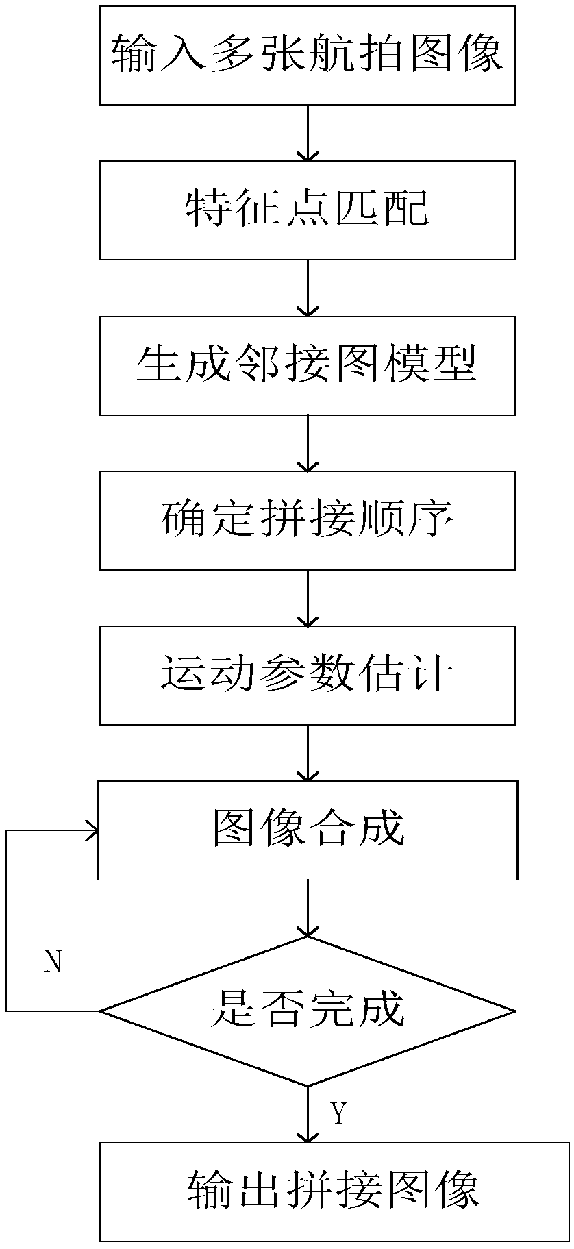
[0030] see figure 1 , a UAV remote sensing image mosaic system based on the neighbor relationship model, including the following steps:

[0031] Step 1: Determination of splicing order

[0032] In order to improve the splicing accuracy, a graph model of the adjacent relationship is established for the image, and the adjacent distance is used as the weight of the edge, and the minimum spanning tree is used to determine the splicing order, which can maximize th...


PUM


Abstract

The invention discloses an unmanned aerial vehicle remote sensing image mosaic system based on an adjacent relation model, belonging to the field of remote sensing image mosaic technology of unmannedaerial vehicle. The adjacent distance is taken as the weight of the edge, the minimum spanning tree is used to determine the mosaic order, which can maximize the use of the clustering of adjacent images; after the mosaic order is determined, the images can be incrementally mosaic onto the cumulative results in order to complete the mosaic; the mapping between images can be replaced by a similaritytransformation or affine transformation; after the mosaic images are transformed, the images are processed by a Graph-Cut algorithm to solve the overlapping seams, then put the images together directly, the invention realizes a multi-view remote sensing image mosaic system of an unmanned aerial vehicle, and the matching precision and the splicing time are balanced, which can not only ensure the extraction of enough features, but also reduce the amount of calculation, improve the calculation speed, and make the color more natural and uniform. The system is simple in operation, practical, easyto operate, easy to maintain, and the whole process does not need manual intervention.

Description

technical field [0001] The invention relates to the technical field of unmanned aerial vehicle remote sensing image splicing, in particular to an unmanned aerial vehicle remote sensing image splicing system based on an adjacent relationship model. Background technique [0002] With the widespread application of drones in military, survey, weather monitoring, pesticide spraying and other fields, more and more domestic and foreign experts and scholars have devoted themselves to the research of key technologies of drones. UAV remote sensing image stitching technology stitches and fuses a series of overlapping remote sensing images to form a relatively complete panoramic view to achieve accurate reconstruction of the original object. It has been widely used in virtual reality technology, remote sensing image processing, computer vision, etc. field. There are mature algorithms and applications for single-viewpoint image stitching. However, multiple viewpoints and scenes are sele...

Claims


Application Information

Patent Timeline
Patent Type & Authority Applications(China)
IPC IPC(8): G06T3/40G06T5/40G06T7/20G06K9/46G06K9/62
CPCG06T3/4038G06T5/40G06T7/20G06T2207/10032G06T2200/32G06V10/462G06F18/22
Inventor 李艳玲汪国平丁泽宇
Owner 长治学院
Why Eureka
Try Eureka