A multi-source microwave remote sensing sea surface wind field data fusion method and device

A sea surface wind field and data fusion technology, applied in the direction of measurement devices, radio wave measurement systems, radio wave reflection/re-radiation, etc., can solve the problems of insufficient fineness, lack of coverage, low spatial resolution, etc., and achieve interpolation Error correction, make up for insufficient spatial resolution, and high-resolution effects

Active Publication Date: 2020-07-17
GUANGZHOU INST OF GEOGRAPHY GUANGDONG ACAD OF SCI
View PDF6 Cites 0 Cited by
  • Summary
  • Abstract
  • Description
  • Claims
  • Application Information

AI Technical Summary

Problems solved by technology

However, the low spatial resolution and the lack of coverage of a single scatterometer track still limit the application of scatterometer wind field products in actual scenarios such as weather forecasting and ocean current simulation.
Therefore, many scholars pay attention to the data fusion research of multi-source scatterometer sea surface wind field products, but the spatial resolution of the fusion data is basically consistent with the original scatterometer data, generally around 25km, which is still not fine enough
In addition, in the process of fusion, the scale difference of remote sensing data from different sources is insufficiently expressed, which affects the accuracy of data fusion

Method used


Image

  • A multi-source microwave remote sensing sea surface wind field data fusion method and device
  • A multi-source microwave remote sensing sea surface wind field data fusion method and device
  • A multi-source microwave remote sensing sea surface wind field data fusion method and device

Examples


Embodiment Construction

[0051] Below, in conjunction with accompanying drawing and specific embodiment, the present invention is described further:

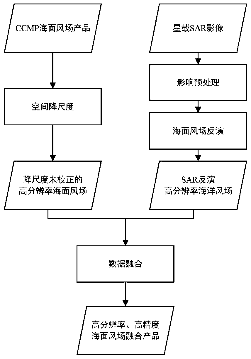
[0052] refer to figure 1 As described, the multi-source microwave remote sensing sea surface wind field data fusion method provided in this embodiment, the method specifically includes

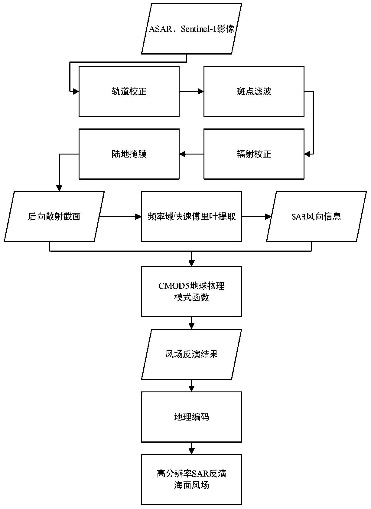
[0053] Obtain SAR images and perform data preprocessing on the SAR images. After the SAR image preprocessing is completed, perform sea surface wind field inversion to obtain SAR inversion sea surface wind field data;

[0054] Obtain the original CCMP sea surface wind field data, and perform spatial downscaling processing on the original CCMP sea surface wind field data to obtain downscaled and uncorrected CCMP sea surface wind field data;

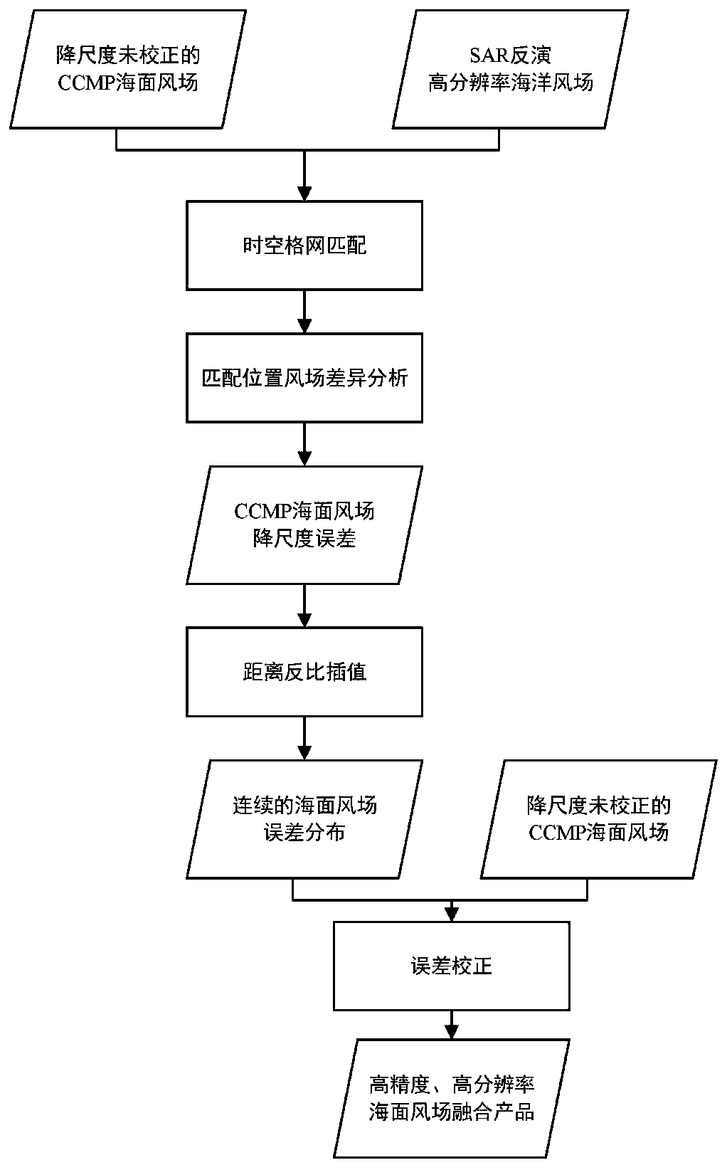
[0055] The geographical difference analysis method is used to fuse the SAR retrieved sea surface wind field data and the downscaled uncorrected CCMP sea surface wind field data to obtain the sea surface wind field fusion data.

[0...


PUM


Abstract

The invention discloses a multi-source microwave remote sensing sea surface wind field data fusion method and a multi-source microwave remote sensing sea surface wind field data fusion device, aimingat the technical problem that existing sea surface wind field products generated based on a scatterometer has wide coverage but low spatial resolution. The method firstly improves the resolution by downscaling through a face-to-point kriging interpolation under the premise of maintaining the precision as much as possible, and then uses a geographic difference analysis method to fuse the SAR to invert a high-resolution wind field and a downscaled wind field, thereby realizing correction of interpolation errors, and generating high-resolution and high-precision sea surface wind field products, which makes up for the shortcomings of insufficient spatial resolution of existing sea breeze products.

Description

technical field [0001] The invention relates to the field of quantitative remote sensing data inversion, in particular to a multi-source microwave remote sensing sea surface wind field data fusion method and a device thereof. Background technique [0002] Microwave scatterometers and radiometers can effectively obtain information on global sea surface wind fields, and are widely used in ocean wind fields, wave fields, weather forecasts, and ocean and atmospheric research, but the spatial resolution is low, 25-50 km, and it is impossible to monitor small and medium sea surface winds. Scale fluctuation and estimation of wind field within 50km near shore. The altimeter can only measure the nadir point, with a resolution of 7 km along the track, but lacks information on the wind direction of the sea surface, and the sweep width is very narrow. Compared with the above-mentioned active and passive microwave sensors, the advantage of synthetic aperture radar (Synthetic Aperture Ra...

Claims


Application Information

Patent Timeline
Patent Type & Authority Patents(China)
IPC IPC(8): G01S13/90
CPCG01S13/904G01S13/9023
Inventor 胡泓达钟凯文吴萍昊
Owner GUANGZHOU INST OF GEOGRAPHY GUANGDONG ACAD OF SCI
Why Eureka
Try Eureka