A sea level change prediction method based on satellite altimetry data

A technology of satellite altimetry and forecasting method, which is applied in forecasting, data processing applications, complex mathematical operations, etc., and can solve the problems of altimetry data preprocessing and SARIMA model construction without solutions

Inactive Publication Date: 2019-01-04
CHINA UNIV OF PETROLEUM (EAST CHINA)
View PDF2 Cites 2 Cited by
  • Summary
  • Abstract
  • Description
  • Claims
  • Application Information

AI Technical Summary

Problems solved by technology

Since satellite altimetry data has multi-point characteristics of geographical spatial distribution, there is no solution for altimetry data preprocessing and SARIMA model construction

Method used


Image

  • A sea level change prediction method based on satellite altimetry data
  • A sea level change prediction method based on satellite altimetry data
  • A sea level change prediction method based on satellite altimetry data

Examples


Embodiment Construction

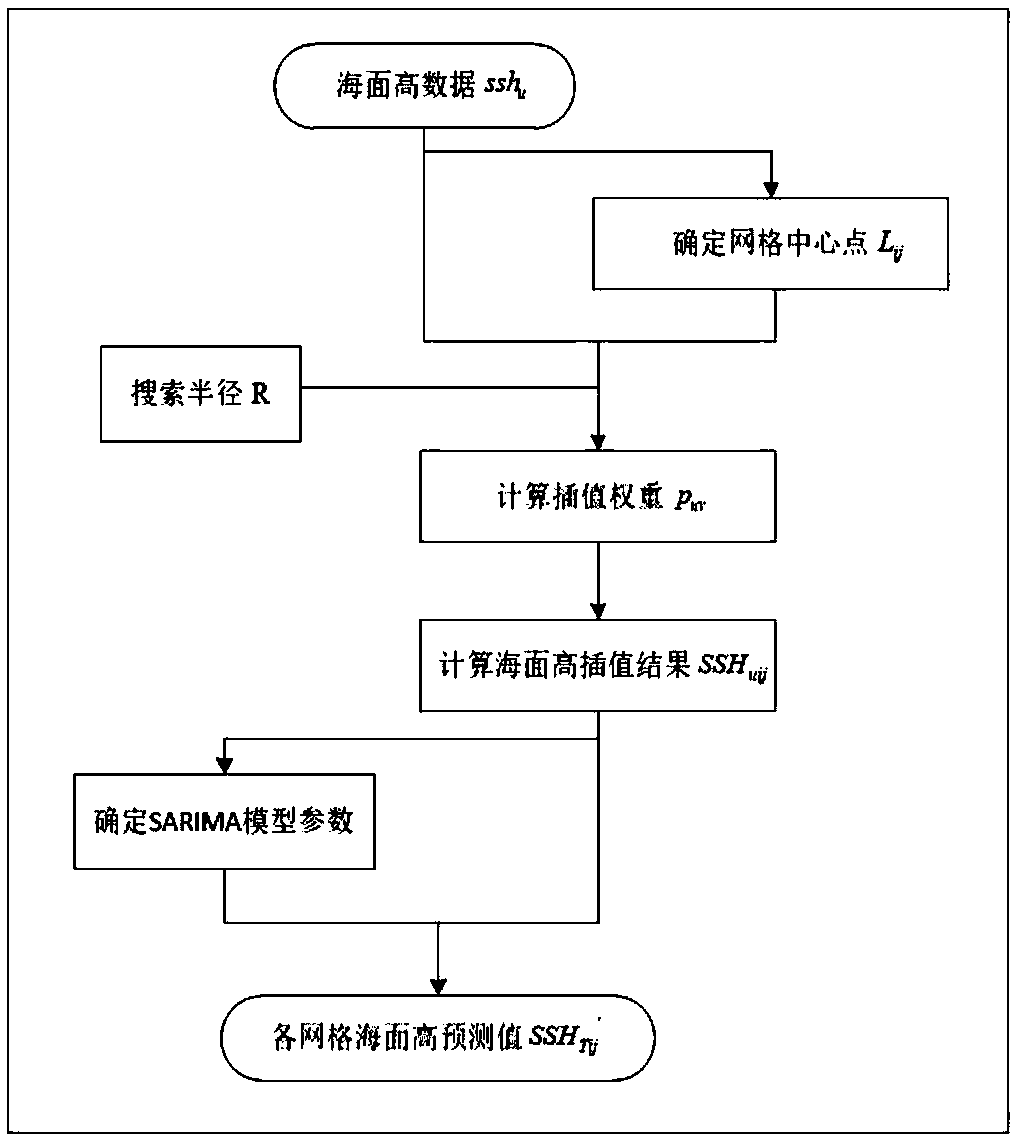
[0033] In order to make the purpose, content, and advantages of the present invention clearer, the specific implementation of the present invention will be described in further detail below in conjunction with the accompanying drawings and embodiments:

[0034] refer to figure 1 , the specific implementation steps of the present invention are:

[0035] (1) Preprocess the satellite altimetry data to obtain the sea surface height data ssh for g months u (1≤u≤g);

[0036] Among them, u represents the ordinal number of the months of sea surface height data involved in modeling in chronological order. Preprocessing includes collinear processing, area selection, self-intersection adjustment, ellipsoid unification, frame unification, and inter-intersection adjustment. g should be greater than 120.

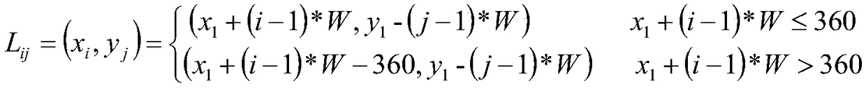
[0037] (2) Take the coordinate point of the upper left corner of the data of the first month (x 1 ,y 1 ) is the center point of the first grid, the grid width W takes half of the ma...


PUM


Abstract

The invention discloses a sea level change prediction method based on satellite altimetry data, and relates to the technical field of satellite altimetry data application. The sea surface height datainterpolation result at the grid center point is calculated by searching the interpolation weight of each sea surface height data within the radius with the determined grid center point as the circlecenter by using the sea surface height long-time series data measured by the satellite altimeter. Then the parameters of seasonal difference autoregressive moving average prediction model are determined at the center of each grid by using the interpolation results of sea surface height data. Finally, the predicted sea surface height at the center of each grid in the study area is calculated basedon the predicted model. By combining the satellite altimetry data with the seasonal difference autoregressive moving average model, the invention can predict the large-scale sea level change.

Description

technical field [0001] The invention relates to the technical field of satellite altimetry data application, in particular to the field of sea level change prediction based on satellite altimetry data. Background technique [0002] In recent years, sea level rise has brought about coastal erosion, salt water intrusion, floods and other disasters, posing a serious threat to human living environment and the safety of life and property. And more and more studies show that sea level is still rising at an accelerated rate. Therefore, the method of sea level change prediction not only has important academic value, but also has great practical significance for the improvement of marine ecological environment. [0003] The high sea level data obtained by using tide gauge data has high precision and long time series, but has the disadvantages of high measurement cost, uneven distribution, and long measurement cycle. Moreover, the measured data is point data, which cannot be measured...

Claims


Application Information

Patent Timeline
Patent Type & Authority Applications(China)
IPC IPC(8): G06Q10/04G06F17/18
CPCG06Q10/04G06F17/18
Inventor 孙钦婷万剑华刘善伟
Owner CHINA UNIV OF PETROLEUM (EAST CHINA)
Why Eureka
Try Eureka