High-accuracy reference equipment and method for walk test under satellite signal-free environment

A technology of satellite signals and reference equipment, applied in the field of navigation and positioning, can solve problems such as the inability to achieve centimeter-level positioning, and achieve the effect of stable and reliable output position

Inactive Publication Date: 2019-01-11
QIANXUN SPATIAL INTELLIGENCE INC
View PDF7 Cites 3 Cited by
  • Summary
  • Abstract
  • Description
  • Claims
  • Application Information

AI Technical Summary

Problems solved by technology

[0004] At present, the existing scheme adopts the form of a backpack, because the form of the backpack is greatly affected by the posture of the person and the displacement of the backpack on the back, especially in a scene that relies heavily on inertial navigation, even a small displacement of the backpack may cause A large cumulative error is generated, and centimeter-level positioning cannot be achieved

Method used


Image

  • High-accuracy reference equipment and method for walk test under satellite signal-free environment
  • High-accuracy reference equipment and method for walk test under satellite signal-free environment

Examples


Embodiment Construction

[0024] Hereinafter, the present invention will be further described in conjunction with the drawings and embodiments.

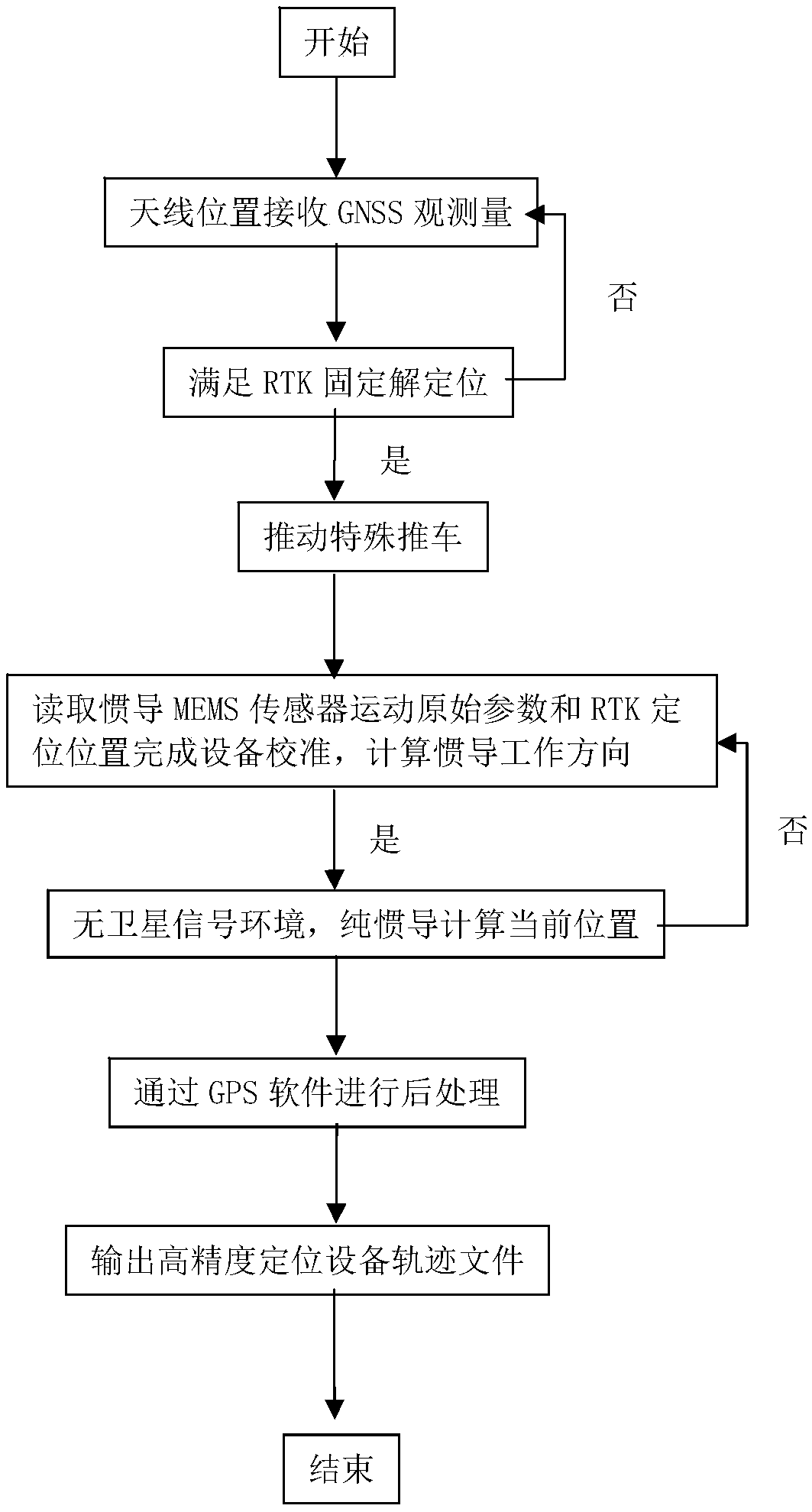
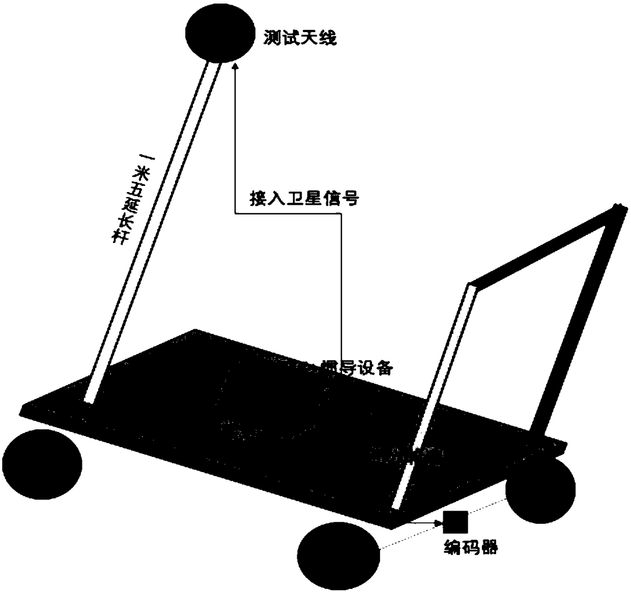
[0025] figure 1 It is the flow chart of the present invention, as shown in the figure, the high-precision positioning equipment receives GNSS observation data through the test antenna to meet the RTK fixed solution positioning, and then pushes a special cart to obtain inertial navigation MEMS (Micro-Electro-Mechanical System, Micro-Electro-Mechanical System, MEMS) sensor original parameters and RTK positioning position for inertial navigation calibration, calculate the inertial navigation direction; after obtaining the movement position and direction of the high-precision positioning equipment, enter the environment without satellite signals, and the high-precision positioning equipment can calculate the current position based on the inertial navigation technology. After the test is completed, the GPS software is used for post-processing, abnormal data analys...


PUM


Abstract

The invention provides high-accuracy reference equipment and method for a walk test under a satellite signal-free environment. The method comprises the following steps that: high-accuracy positioningequipment receives GNSS (Global Navigation Satellite System) measurement data through a test antenna to meet RTK (Real-Time Kinematic) fixed solution positioning, wherein the high-accuracy positioningequipment comprises RTK and inertial navigation equipment; a trolley is pushed to dynamically acquire original motion parameters and an RTK location of the inertial navigation equipment to complete calibration of the high-accuracy positioning equipment and calculate a working direction of the inertial navigation equipment; after a motion position and direction of the high-accuracy positioning equipment are acquired, the high-accuracy positioning equipment enters the satellite signal-free environment; the satellite signal-free environment calculates the current position through the inertial navigation equipment; and after the test is completed, post processing, abnormal data analysis and smoothing processing are performed through GPS (Global Positioning System) software to output a high-accuracy positioning equipment track file. The equipment provided by the invention is fixed on the special trolley, so no direction difference is generated from an actual driving direction of the special trolley; and under the satellite signal-free environment, the position can be stably and reliably output.

Description

technical field [0001] The invention relates to the technical field of navigation and positioning, in particular to a high-precision reference device and method for walking tests in an environment without satellite signals. Background technique [0002] To achieve high-precision positioning in an environment without satellite signals, it mainly relies on inertial navigation technology. Inertial navigation (referred to as inertial navigation) technology uses the parameters in the motion of the accelerometer and gyroscope to perform integral operations to obtain the benchmark for high-precision positioning equipment Location. The use of inertial navigation technology needs to obtain the position and direction of the device before entering the inertial navigation, which requires the use of carrier phase technology (RTK or PPK) to obtain centimeter-level precision position in an open environment; RTK (Real-Timekinematic, real-time dynamic) is The differential method of real-tim...

Claims


Application Information

Patent Timeline
Patent Type & Authority Applications(China)
IPC IPC(8): G01S19/43G01S19/49G01C21/16
CPCG01C21/165G01S19/43G01S19/49
Inventor 高求兵
Owner QIANXUN SPATIAL INTELLIGENCE INC
Why Eureka
Try Eureka