Fast extraction method of suspected illegal land use information based on unmanned aerial vehicle images

An extraction method and unmanned aerial vehicle technology, applied in image enhancement, image analysis, image data processing, etc., can solve the problems of limited supervision work, insufficient deepening and expansion of remote sensing monitoring results, low methods and technologies, etc.

Inactive Publication Date: 2019-01-15
NANJING CENT CHINA GEOLOGICAL SURVEY +1
View PDF4 Cites 10 Cited by
  • Summary
  • Abstract
  • Description
  • Claims
  • Application Information

AI Technical Summary

Problems solved by technology

Affected by many factors such as remote sensing sensors and carrying platforms, remote sensing data acquisition methods, and processing methods, coupled with the fact that land use monitoring has a strong purpose and current situation, the results of remote sensing monitoring are importa

Method used


Image

  • Fast extraction method of suspected illegal land use information based on unmanned aerial vehicle images

Examples


Embodiment Construction

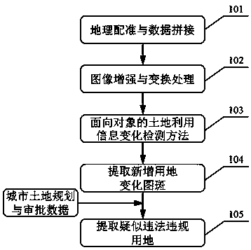
[0014] Such as figure 1 As shown in Fig. 1, the rapid extraction method of suspected illegal and illegal land use information based on UAV images includes the following steps:

[0015] (1) Georeferencing and data stitching of drone images 101;

[0016] (2) Enhancement and transformation processing 102 of UAV images;

[0017] (3) Object-oriented land use information change detection method 103;

[0018] (4) Extract newly added land use change map spot 104;

[0019] (5) Extract information on suspected illegal land use105.

[0020] The geo-registration and data stitching algorithm 101 for selecting and constructing UAV images specifically includes: between adjacent images with a certain degree of overlap, use a certain feature point extraction algorithm to find pairs of pixels with the same name, and establish an optimal geometric transformation model , to achieve georeferencing of UAV images. Affected by human factors and technical conditions, there are uncertainties in th...


PUM


Abstract

The invention provides a method for quickly extracting suspected illegal land use information based on unmanned aerial vehicle (UAV) images. (2) Enhancement and transformation of unmanned aerial vehicle images; (3) Object-oriented land use information change detection method; (4) extracting new land change patches; (5) Extracting the information of suspected illegal land use. Advantages: based onspatial information technology, deepening and expanding geographical matching, data splicing, image enhancement change, a method for processing image data and extracting information of unmanned aerialvehicle includes detecting information change, combined with the spatial analysis model of GIS, this paper realizes the comparative analysis between multi-source and multi-temporal remote sensing data and between remote sensing image data and urban construction planning approval data, quickly obtains the suspected illegal land use situation, and provides technical services and decision-making basis for urban land resources monitoring and management.

Description

technical field [0001] The invention relates to a method for quickly extracting land use information suspected to be in violation of laws and regulations based on drone images, and belongs to the technical field of signal and information processing. Background technique [0002] Land resources are the environmental resources and material basis for the survival and development of human beings. The degree of utilization and development trend of their development will directly affect the integrated and coordinated development of the social economy. Therefore, the dynamic supervision of land use and the investigation and punishment of illegal land use are the key factors in my country's current land resources management. key work. With the intensification of my country's urbanization process and the continuous expansion of urban space, the demand for urban construction land has increased significantly, the contradiction between supply and demand of land resources has continued to...

Claims


Application Information

Patent Timeline
IPC IPC(8): G06K9/00G06K9/62G06T7/33G06T7/20
CPCG06T7/20G06T7/337G06T2207/10032G06T2207/30181G06V20/13G06F18/24
Inventor 周权平杨强陈动郑加柱陈红华何立恒陈健姜月华张洁蔡逸涛
Owner NANJING CENT CHINA GEOLOGICAL SURVEY
Why Eureka
Try Eureka