Beidou based urban land optimization system
A city and Beidou technology, applied in the field of urban land use optimization system, can solve the problem of carbon emission research at the city level, and it is very rare, and achieve the effect of promoting sustainable use and development
- Summary
- Abstract
- Description
- Claims
- Application Information
AI Technical Summary
Problems solved by technology
Method used
Image
Examples
Embodiment Construction
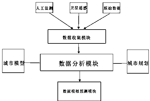
[0008] refer to figure 1 It can be seen that the present invention provides a Beidou-based urban land use optimization system, which specifically includes a data collection module, a data analysis module, and a data simulation prediction module; the three modules are all connected to each other in the system; the data collection module Using various collection methods, including satellite remote sensing, manual monitoring, historical data, etc., to collect urban land use data information from multiple angles; the data analysis module is compatible with the analysis of various factors such as urban models, urban policies, and urban orientation, and analyzes the collected data. The data is optimized and analyzed; the data simulation module further optimizes the processed data to obtain a prediction and simulation report of urban land use.
[0009] The invention carries out monitoring and analysis based on Beidou satellite remote sensing data, establishes a complete algorithm, an...
PUM
 Abstract
Description
Claims
Application Information
 - R&D
- Intellectual Property
- Life Sciences
- Materials
- Tech Scout
- Unparalleled Data Quality
- Higher Quality Content
- 60% Fewer Hallucinations
Browse by: Latest US Patents, China's latest patents, Technical Efficacy Thesaurus, Application Domain, Technology Topic, Popular Technical Reports.
© 2025 PatSnap. All rights reserved.Legal|Privacy policy|Modern Slavery Act Transparency Statement|Sitemap|About US| Contact US: help@patsnap.com


