Real-time data collection terminal system and collection method for land intensive use survey

A real-time data acquisition and terminal system technology, applied in the direction of data acquisition and recording, can solve problems such as cost, and achieve the effect of improving accuracy, increasing time-consuming, and improving efficiency

Active Publication Date: 2015-09-16
安徽前锦空间信息科技有限公司
View PDF3 Cites 0 Cited by
  • Summary
  • Abstract
  • Description
  • Claims
  • Application Information

AI Technical Summary

Problems solved by technology

[0004] The present invention provides a real-time data acquisition terminal system for land intensive utilization survey and its method to overcome the traditional way of managing land site survey data by means of drawings and tables and solve the problem of consuming a lot of manpower, material and financial resources for land management in the traditional way. collection method

Method used


Image

  • Real-time data collection terminal system and collection method for land intensive use survey
  • Real-time data collection terminal system and collection method for land intensive use survey
  • Real-time data collection terminal system and collection method for land intensive use survey

Examples


Embodiment 1

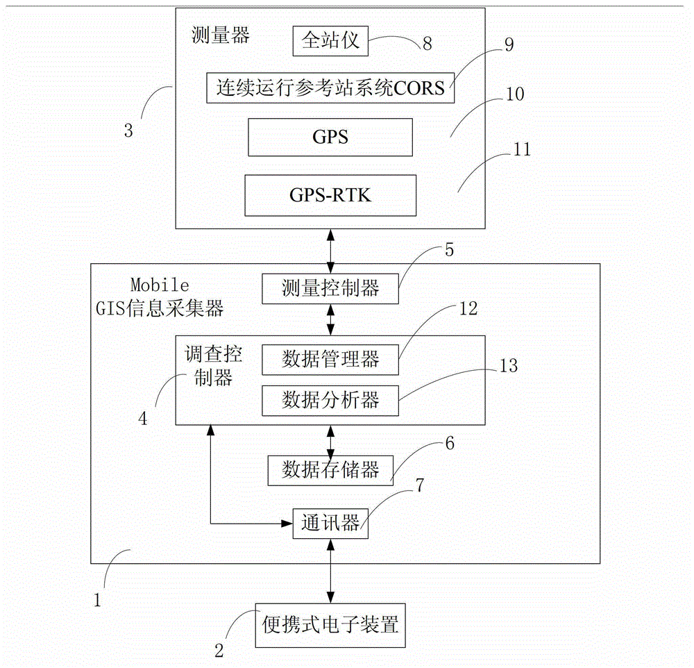
[0046] see figure 1 , the real-time data acquisition terminal system for land intensive utilization survey of the present invention includes a Mobile GIS information collector 1, a portable electronic device 2 and a measuring device 3. The Mobile GIS information collector 1 is connected to the portable electronic device 2 via bluetooth or a data line, and can also be used as software in the portable electronic device 2 (as described in Embodiment 2 below), the portable electronic device 2 and the measuring device 3 Electrically connected, the portable electronic device 2 sends a control signal to start the real-time data collection terminal system for land intensive utilization survey to complete the data collection of the measuring device 3 to obtain data information and perform data processing on the data information. The portable electronic device 2 displays the information of the Mobile GIS information collector 1 on the portable electronic device 2 for analysis and storag...

Embodiment 2

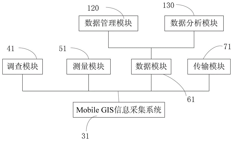
[0053] Please combine figure 2 and image 3 , in combination with Embodiment 1, the portable electronic device 2 is electrically connected to the measuring device 3, and the portable electronic device 2 sends a control signal to start the real-time data collection terminal system for the land intensive utilization investigation, so as to complete the data collection of the measuring device 3 and obtain data information, and perform data processing on the data information. This system can also adopt software design and be arranged on portable electronic devices 2 such as PDA palmtop computer and notebook computer, and use Mobile GIS as the platform for data collection, management and analysis. The real-time data acquisition terminal system 31 of the land intensive utilization investigation of the present invention can be applicable to various brands, various types of total stations, GPS, GPS-RTK, CORS and other measuring equipment, and the measuring equipment is connected to ...


PUM


Abstract

The invention relates to a terminal system and method for collecting real-time data of intensive land use survey, which are applied to a portable electronic device. The portable electronic device is electrically connected with a measurer and is used for transmitting a control signal for starting the system to finish the data collection of the measurer so as to obtain data information and process the data information. The system comprises a transmission module, a survey module, a measuring module, a data module and the transmission module, wherein the transmission module is used for receiving the control signal; the survey module is used for transmitting a measuring signal, a storage signal and a transmission signal according to the control signal; the measuring module is used for collecting the data information of the measurer according to the measuring signal; the data module is used for storing the data information according to the storage signal; and the transmission module is also used for transmitting the data information to the portable electronic device according to the transmission signal. The terminal system for collecting the real-time data of the intensive land use survey, provided by the invention, has the advantage that digital, integrated and mobile collection and real-time transmission of land change information survey are achieved. The invention further relates to a collecting method of the system.

Description

technical field [0001] The invention belongs to the field of information collection, processing and analysis, in particular to a real-time data collection terminal system and a collection method for land intensive utilization investigation. Background technique [0002] With the needs of economic and social development, land has become a scarce resource for social needs. Its information investigation and collection play a very important role in strengthening land management, scientific planning, reducing non-agricultural construction land, improving land use quality, and reducing waste of land resources. . [0003] At present, my country's land survey adopts the method of comprehensive survey, and comprehensively uses methods such as field survey statistics and remote sensing monitoring. Among them, field surveys generally have problems such as outdated land survey techniques, low data and information digitization rate, and low management efficiency. Contents of the inven...

Claims


Application Information

Patent Timeline
Patent Type & Authority Patents(China)
IPC IPC(8): G06F17/40
Inventor 吕伟才余学祥柯福阳赵兴旺王新志张美微
Owner 安徽前锦空间信息科技有限公司
Why Eureka
Try Eureka