A remote sensing image cloud identification n method based on depth learning

A technology of remote sensing image and deep learning, applied in the field of remote sensing image cloud recognition based on deep learning, can solve the problem of low cloud recognition accuracy, improve accuracy and efficiency, and improve the effect of deep convolutional neural network structure

Inactive Publication Date: 2019-01-22
CHINA UNIV OF GEOSCIENCES (BEIJING)
View PDF2 Cites 12 Cited by
  • Summary
  • Abstract
  • Description
  • Claims
  • Application Information

AI Technical Summary

Problems solved by technology

[0007] The purpose of the present invention is to provide a method for cloud recognition in remote sensing images

Method used


Image

  • A remote sensing image cloud identification n method based on depth learning
  • A remote sensing image cloud identification n method based on depth learning
  • A remote sensing image cloud identification n method based on depth learning

Examples


Embodiment 1

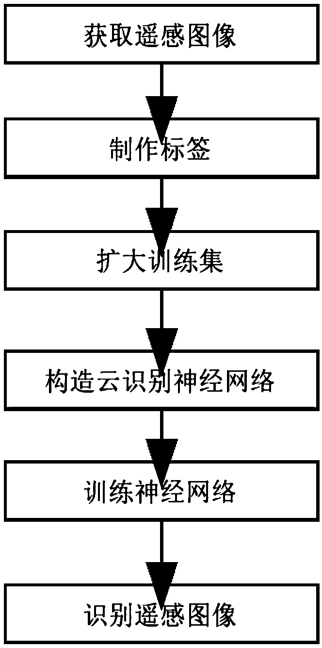
[0020] Example 1 Acquiring and making training data

[0021] The training set needs to be made first, so a large number of remote sensing images are required. Using the crawler technology in Python, the crawler downloads the remote sensing satellite images in the website for label production and verification data sets. In addition, operations such as rotation, cutting, and inversion can be used to expand the training set by multiples, greatly increasing the number of training pictures. After acquiring the pictures, it is necessary to perform pixel-level classification on the pixels of the remote sensing images. Here, the label is made through the Ecognition software. In the process of cloud extraction, the image is first segmented according to the similarity of pixels, and a certain area is selected in the segmented image as a sample of the class, and then the separated areas that may belong to the same class are merged to achieve the purpose of classification .

Embodiment 2

[0022] Example 2 deploying the Caffe-SegNet framework

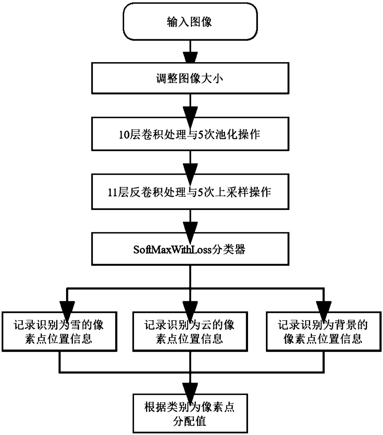
[0023] Caffe-SegNet is a change on the Caffe framework. Compared with the original SegNet framework, there are many differences. It adds a new input layer, so that the Caffe framework can directly read the picture name in the txt file, and directly use the picture as a batch. Input values ​​are fed into a deep neural network. In addition, an upsampling layer is added, which is not available in the native Caffe package. The upsampling layer can restore the reduced feature values ​​after pooling. After deploying Caffe-SegNet, compile its Python interface——PyCaffe, which makes it possible to use Python to call some operations in the Caffe framework, such as building a neural network, inputting data into the network, and obtaining output data of each layer, etc. Encapsulate some command line operations to facilitate the processing of input and output data and the writing of GUI.

Embodiment 3

[0024] Embodiment 3 design neural network structure

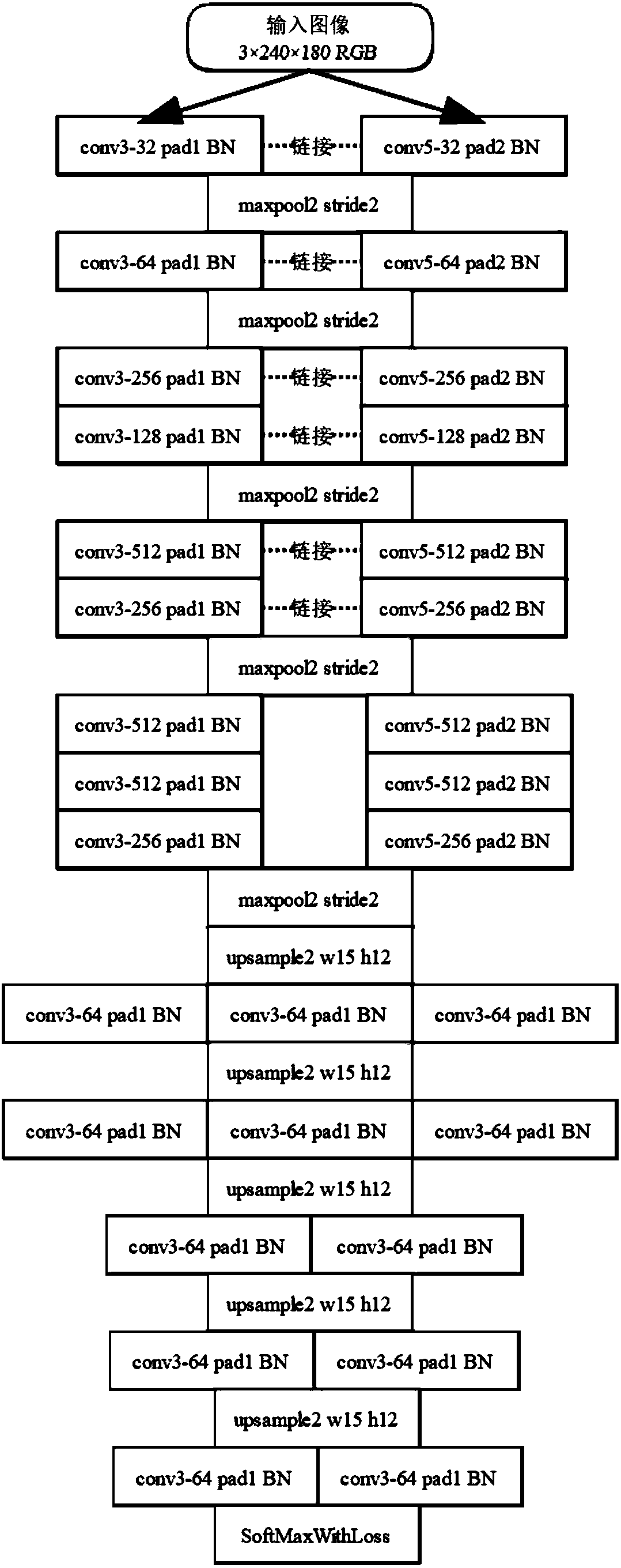
[0025] Inspired by Google's inception v3 model, the newStructure neural network "widens" the SegNet model. In the same convolution, not only one size of convolution kernel is used, but multiple sizes of convolution kernels are used for convolution operations.

[0026] We can design and implement the deep neural network in the Caffe framework. In the remote sensing image cloud recognition deep convolutional neural network, convolution kernels with sizes of 3×3 and 5×5 are used, and it has a 21-layer convolutional structure. , which contains 10 layers of convolutional layers and 11 layers of deconvolutional layers, the structure of the deep convolutional network is as follows figure 2 shown.


PUM


Abstract

The invention discloses a remote sensing image cloud identification method based on depth learning. The method comprises the following steps: automatically acquiring remote sensing cloud images, making remote sensing images into training sets and expanding the existing training sets, and making labels in the training sets, constructing a deep convolution neural network based on SegNet neural network structure with multi-scale convolution kernel and high symmetry and for restoring the feature map i by deconvolution layer finally, to avoid over-fitting, under-fitting and gradient disappearance in network training, adopting the method of subsection training, after the training, extracting the feature of the remote sensing image by using the obtained weight file, and carrying out cloud detection at the pixel level. The remote sensing image cloud identification depth convolution neural network of the invention improves the retrieval accuracy by utilizing multi-scale convolution and high symmetry.

Description

technical field [0001] The invention relates to the technical field of image recognition, in particular to a remote sensing image cloud recognition method based on deep learning. Background technique [0002] Through the processing and analysis of remote sensing images, remote sensing images have been widely used in agricultural forestry management, geological and mineral prediction, natural environment detection, weather forecasting, etc. However, more than 50% of the earth's upper sky is covered by a large number of clouds, which leads to a large amount of information in remote sensing images being blocked by clouds, which has a great impact and interference on the actual application of remote sensing images. [0003] At present, there are many methods for remote sensing image cloud recognition, one of which is to use remote sensing image processing software. The remote sensing image processing software first cuts the image carefully, and divides the areas with the same o...

Claims


Application Information

Patent Timeline
IPC IPC(8): G06K9/00G06K9/62G06F16/953G06N3/04
CPCG06V20/13G06N3/045G06F18/24G06F18/214
Inventor 王玉柱陆君宇
Owner CHINA UNIV OF GEOSCIENCES (BEIJING)
Why Eureka
Try Eureka