Lidar three-dimensional mapping method based on semantic point cloud registration

A laser radar, point cloud registration technology, applied in the field of communication, can solve the problems of high complexity, high complexity, and deviation of point clouds, and achieve the effect of low registration complexity, improved accuracy, and improved reliability.

Active Publication Date: 2019-02-15
XIDIAN UNIV
View PDF8 Cites 21 Cited by
  • Summary
  • Abstract
  • Description
  • Claims
  • Application Information

AI Technical Summary

Problems solved by technology

This method only uses the extracted edge points and plane points for registration, and there is a high probability of mismatching, and because this method is looking for the point closest to the point to be registered during registration, there will be errors beyond the threshold, so this method The disadvantage is that the probability of mismatch is high, and there is a deviation in the calculation of the motion pose transformation matrix of the lidar
Since this method needs to traverse all points in the point cloud in the step of finding the corresponding nearest neighbor point, the complexity of calculating the optimal transformation matrix is ​​O(m 3 ,n 3 ), for a three-dimensional point cloud on the order of millions, the complexity of this method is too high, so the disadvantage of this method is that the complexity of the point cloud registration process is too high, and for large-scale point cloud registration Efficiency is difficult to achieve real-time 3D mapping

Method used


Image

  • Lidar three-dimensional mapping method based on semantic point cloud registration
  • Lidar three-dimensional mapping method based on semantic point cloud registration
  • Lidar three-dimensional mapping method based on semantic point cloud registration

Examples


Embodiment Construction

[0041] The present invention will be further described below in conjunction with the accompanying drawings.

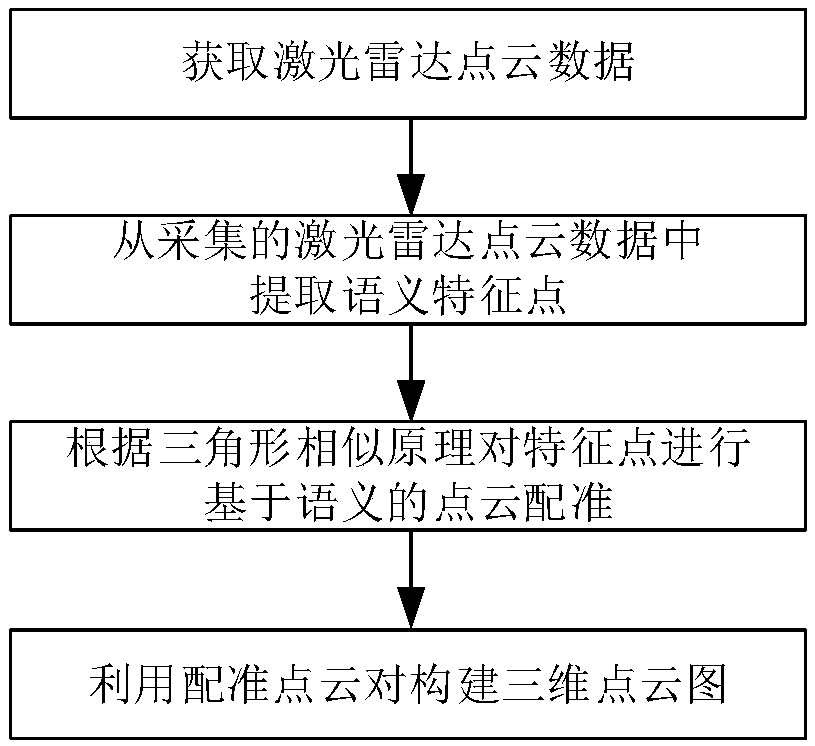
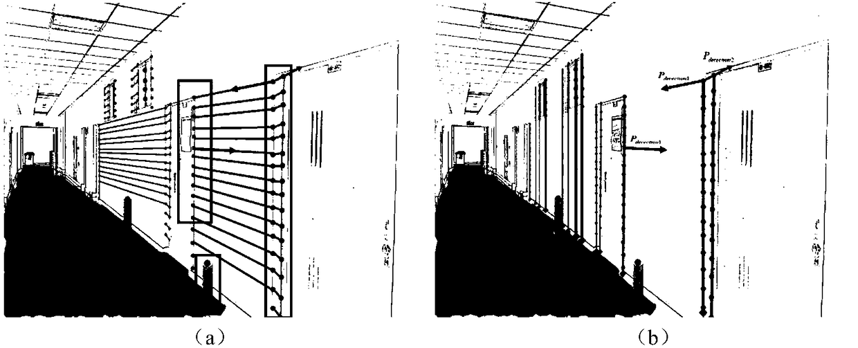
[0042] refer to figure 1 , to further describe the specific steps of the present invention.

[0043]Step 1. Obtain lidar point cloud data.

[0044] Fix the lidar to the rotating platform controlled by the motor, follow the right-hand rule, take the current position of the lidar as the origin of the radar coordinate system, and establish the radar coordinate system directly in front of the lidar as the z-axis.

[0045] Use the cosine formula to calculate the coordinate value of each point scanned by the lidar on each axis in the radar coordinate system, and output a point cloud with coordinate information.

[0046] The described cosine formula is as follows:

[0047] a l =b l ×cosθ l

[0048] Among them, a l Indicates the coordinate value of the lth point in the point cloud corresponding to the axis of the three axes of the radar coordinate system, b l Represen...


PUM


Abstract

The invention relates to a three-dimensional mapping method of a lidar based on semantic point cloud registration, which comprises the following steps of: (1) acquiring point cloud data of an object to be scanned; (2) extracting semantic feature points from the collected lidar point cloud data; (3) According to the triangle similarity principle, registering the feature points based on semantics; (4) Constructing 3D point cloud image by using registration point cloud pairs. The feature points extracted by the invention have poles, three categories of intersections and vertices, the probabilityof mismatch decreases during registration, Reduced Matching Complexity, improve real-time performance of map structure, The accuracy of calculating the moving posture of the laser radar is improved byusing the registration point cloud, the position information of the point cloud is corrected by using the moving posture, and the map constructed by projecting to the world coordinate system is moreaccurate. The invention only utilizes the scanning data of the laser radar to complete online drawing of the high-quality three-dimensional point cloud image, and has the advantage of error caused byaccurate mismatch.

Description

technical field [0001] The invention belongs to the technical field of communication, and further relates to a three-dimensional laser radar mapping method based on semantic point cloud registration in the technical field of laser radar surveying and mapping. The invention can be applied to the mobile robot's surveying and mapping of the terrain and the perception of the three-dimensional environment, and registers adjacent point clouds with known spatial point positions, thereby constructing a complete three-dimensional point cloud map. Background technique [0002] Point cloud registration is a key technology in the application of lidar simultaneous positioning and 3D mapping. During the point cloud registration process, if the lidar itself moves too fast, the motion distortion caused by itself during scanning will cause registration errors, which will affect the construction of the 3D point cloud image. In addition, the currently proposed point cloud registration method ...

Claims


Application Information

Patent Timeline
Patent Type & Authority Applications(China)
IPC IPC(8): G06T7/33
CPCG06T7/33G06T2207/10028G06T2207/10044
Inventor 孙伟纪晓凤
Owner XIDIAN UNIV
Why Eureka
Try Eureka