A matching method of bim model and point cloud data

A point cloud data, matching method technology, applied in image data processing, electrical digital data processing, special data processing applications, etc., can solve the problem of three-dimensional matching degree, there is no easier to operate and more accurate matching method, etc., to improve convenience and the effects of increased accuracy, precision and reliability, supported by accurate and reliable data

Inactive Publication Date: 2019-03-26
CHINA RAILWAY SHANGHAI ENGINEERING BUREAU GROUP CO LTD
View PDF4 Cites 13 Cited by
  • Summary
  • Abstract
  • Description
  • Claims
  • Application Information

AI Technical Summary

Problems solved by technology

In recent years, for some special structures, such as circular tunnels, the point cloud model can be sliced ​​into two-dimensional point cloud rings of multiple sections, and the two-dimensional point cloud coordinates of the sections are

Method used


Image

  • A matching method of bim model and point cloud data
  • A matching method of bim model and point cloud data
  • A matching method of bim model and point cloud data

Examples


Embodiment 1

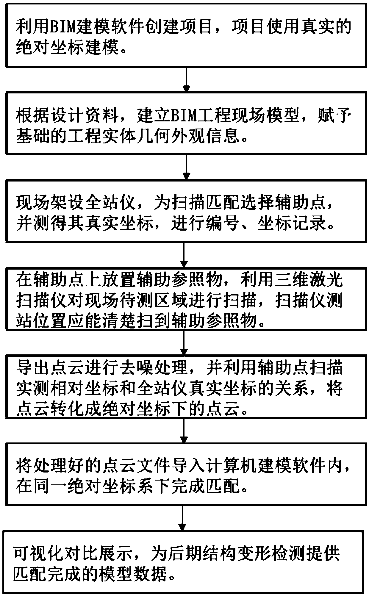
[0030] see figure 1 , the following takes an engineering structure as an example to introduce the implementation steps of this method.

[0031] First, according to the engineering design and planning information, use BIM modeling software to create a new project. In the preparation stage, first define the origin of the project, and assign real coordinates to the origin, and define the true north direction, so as to set the completed modeling coordinate system and real coordinates systems are compatible with each other.

[0032] In the built project, the real absolute coordinate modeling is used, and the BIM engineering entity model is established according to the design data, and the geometric appearance information of the engineering entity based on the model is given. The built BIM model is the initial model, which is used as the comparison object of the subsequent model .

[0033] Then, the point cloud model acquisition of the real structure on site will be carried out. ...


PUM


Abstract

The invention relates to the technical field of engineering construction, Specifically, it is a matching method between bim model and point cloud data, At least three auxiliary reference object shallbe set up on that project site, and the point cloud data of the engineering structure and the auxiliary reference object are collected by the three-dimensional scanner to obtain the relative coordinates, The absolute coordinates of the auxiliary reference object are compared with the relative coordinates of the auxiliary reference object in the point cloud data and the real absolute coordinates ofthe engineering structure are obtained by correcting the point cloud data with the registration algorithm. compared with that prior art, Its advantages are: auxiliary reference objects are set and positioned on site, the relative coordinates of the point cloud data are converted into absolute coordinates by using the real absolute coordinates of the auxiliary reference object through registrationalgorithm, In order to achieve the matching of computer-side information model and point cloud model, improve the convenience and accuracy of scanning matching, and provide accurate and reliable datasupport for the later visual display of structural deformation detection.

Description

technical field [0001] The invention relates to the technical field of engineering construction, in particular to a method for matching bim models and point cloud data. Background technique [0002] In reverse engineering, the point data set on the surface of the product obtained by measuring instruments is also called a point cloud. Among them, the number of points obtained by using a three-dimensional coordinate measuring machine is relatively small, and the distance between points is relatively large, which is called sparse points. Cloud; and the point cloud obtained by using a 3D laser scanner or a photo scanner, the number of points is relatively large and dense, which is called a dense point cloud. [0003] The 3D point cloud collection of engineering structures has a wide demand in the engineering field due to the advantages of fast collection speed, large number of points, and low operation difficulty. Traditional three-dimensional surveying and mapping methods, suc...

Claims


Application Information

Patent Timeline
IPC IPC(8): G06T7/30G06T15/00G06T19/00G06F17/50
CPCG06T15/00G06T19/00G06T2207/10028G06T7/30G06F30/20
Inventor 翟昌骏唐俊谢雄耀姚松柏朱文杰张久昌郭乐
Owner CHINA RAILWAY SHANGHAI ENGINEERING BUREAU GROUP CO LTD
Why Eureka
Try Eureka