A multi-UAV (Unmanned Aerial Vehicle) collaborative map construction method oriented to data sharing

A multi-UAV and map construction technology, which is applied in image data processing, image enhancement, image analysis, etc., can solve the problems of long time-consuming map fusion process and slow return to optimized maps, etc.

Active Publication Date: 2019-04-02
NAT UNIV OF DEFENSE TECH
View PDF7 Cites 19 Cited by
  • Summary
  • Abstract
  • Description
  • Claims
  • Application Information

AI Technical Summary

Problems solved by technology

[0040] The technical problem to be solved by the present invention is to provide a multi-UAV cooperative map construction method for da

Method used


Image

  • A multi-UAV (Unmanned Aerial Vehicle) collaborative map construction method oriented to data sharing
  • A multi-UAV (Unmanned Aerial Vehicle) collaborative map construction method oriented to data sharing
  • A multi-UAV (Unmanned Aerial Vehicle) collaborative map construction method oriented to data sharing

Examples


Embodiment Construction

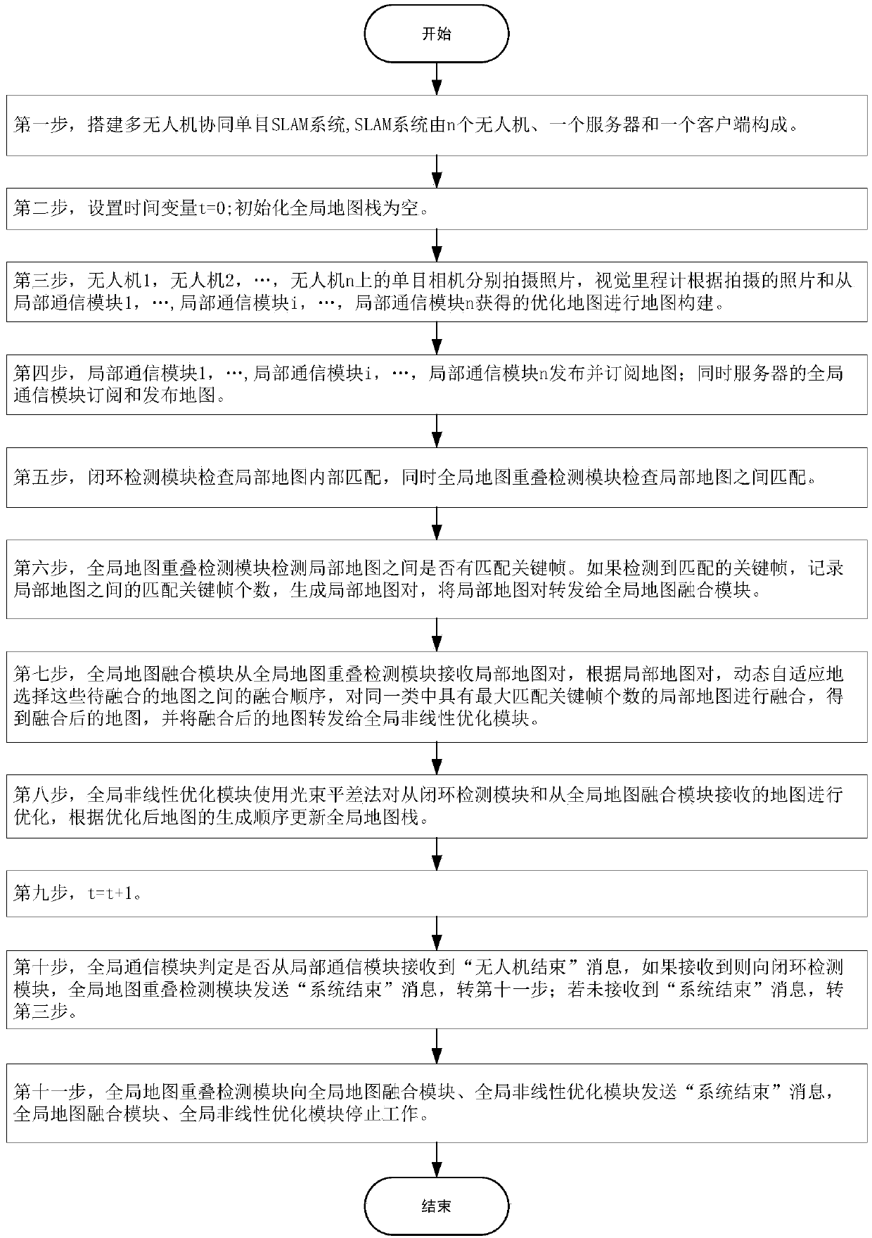
[0116] Such as figure 2 Shown, the present invention comprises the following steps:

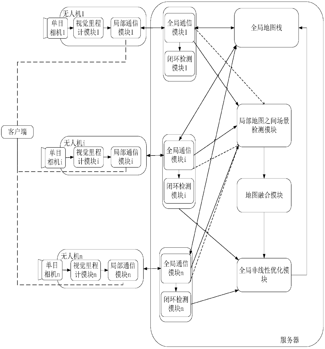
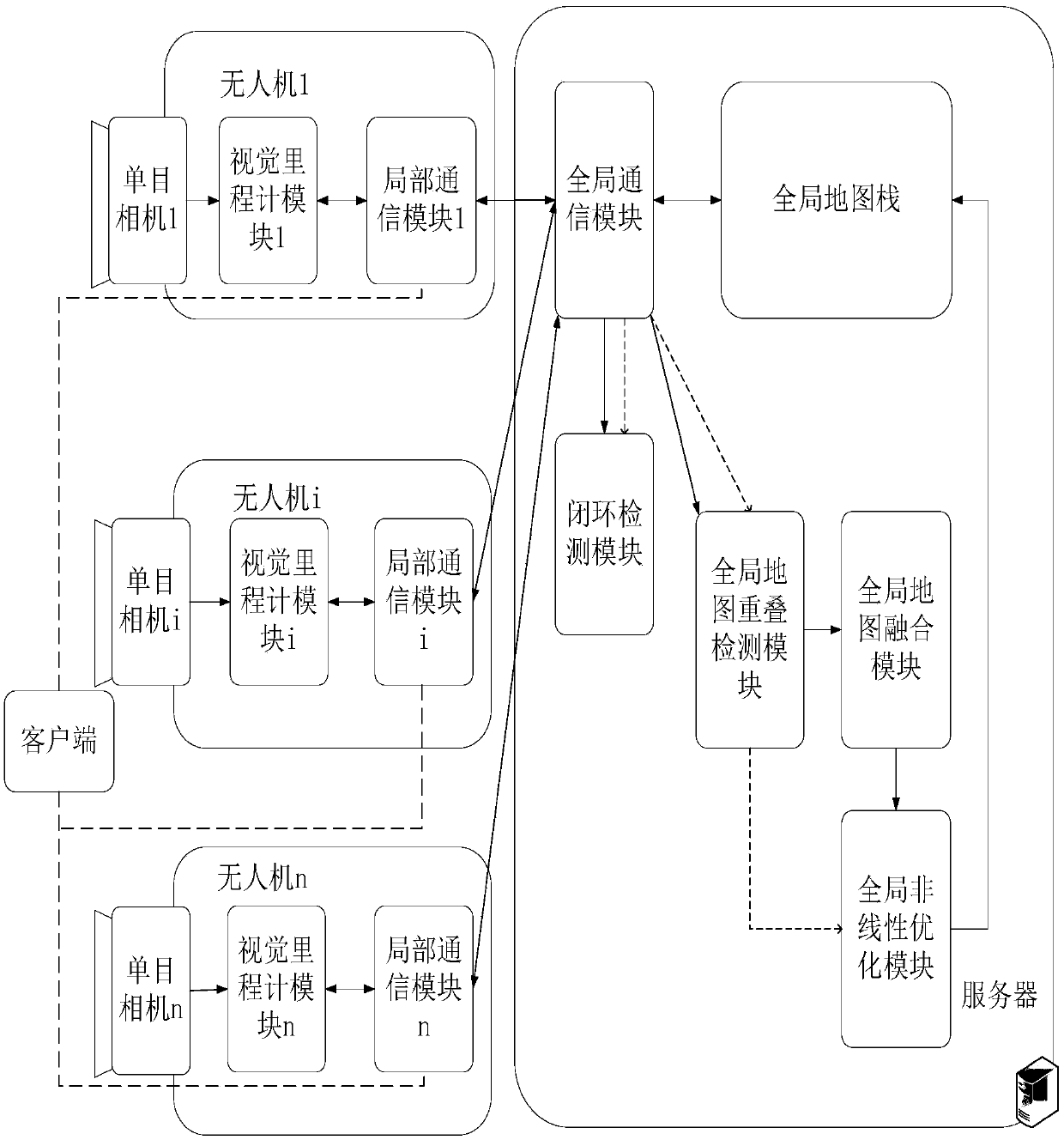
[0117] The first step is to build a multi-UAV cooperative monocular SLAM system. Such as image 3 As shown, the multi-UAV cooperative monocular SLAM system consists of n UAVs, a server and a client. A computer that can run software programs is installed on the drone; the server is a computing device that has abundant storage resources, can provide external services, and can run computing-intensive applications; the client is a resource-controllable computing device with good computing power. Software that controls the operation of n drones is installed on it. The client is connected to n drones (represented as drone 1, ..., drone i, ..., drone n, 1≤i≤n) through a wireless network, and the server is also connected to n drones through a wireless network. Man-machine connection.

[0118] The client controls the start and stop of UAV 1, ..., UAV i, ..., UAV n map construction by sending "Dr...


PUM


Abstract

The invention discloses a multi-UAV (Unmanned Aerial Vehicle) collaborative map construction method oriented to data sharing, and aims to solve the problems of long time consumption and slow map return optimization in a map fusion process. According to the technical scheme, the multi-unmanned aerial vehicle cooperative SLAM system oriented to data sharing is improved, a global map overlapping detection module in the system detects whether matched key frames exist between maps or not within a period T, the number of the matched key frames is recorded, and a local map pair is generated; and a global map fusion module in the system clusters the maps according to the local map pairs, dynamically and adaptively selects a fusion sequence between the local maps in the local map pairs, and fuses the local maps with the maximum number of matched key frames in the same class. According to the method, map fusion can be adaptively carried out according to the change of the local map constructed bythe unmanned aerial vehicle and the sequence which is most beneficial to improving data sharing, so that map construction has correct fusion time, the fusion sequence can be adaptively adjusted, andthe map construction accuracy and efficiency are improved.

Description

technical field [0001] The invention relates to the technical field of robot simultaneous positioning and map construction, in particular to a method for multi-UAV cooperative map construction oriented to data sharing. Background technique [0002] Simultaneous localization and mapping (SLAM) specifically refers to the subject equipped with a specific sensor. In the absence of environmental prior information, the environment model is established during the movement process and its own movement is estimated at the same time. It is the realization of intelligent unmanned vehicles. The key to the autonomous movement of the system. In the past 30 years, the fundamental properties of visual SLAM using images containing rich environmental information as input have been intensively studied. At present, in more and more scenarios, such as disaster surveys, bridge inspections and other fields, drones alone can no longer meet the needs of applications. Therefore, multi-UAV collabora...

Claims


Application Information

Patent Timeline
IPC IPC(8): G06T3/40G06T5/50G01C21/00
CPCG06T3/4038G06T5/50G01C21/005G06T2207/20221G06T2207/10016
Inventor 史殿习杨卓越陈驰洪臣
Owner NAT UNIV OF DEFENSE TECH
Why Eureka
Try Eureka