XEmbed-based interactive map component dynamic embedding method and system

An interactive and map technology, applied in the field of geographic information system, to achieve the effect of easy implementation, simplicity and ease of use, and improved interactive operation capabilities

Active Publication Date: 2019-04-05
CHINA CENT FOR RESOURCES SATELLITE DATA & APPL
View PDF5 Cites 4 Cited by
  • Summary
  • Abstract
  • Description
  • Claims
  • Application Information

AI Technical Summary

Problems solved by technology

[0007] The technical problem of the present invention is: to overcome the deficiencies of the prior art, a method and system for dynamic embedding of interactive map components based on XEmbed are proposed, which solves the problem of convenient and quick integration of non-professional developers such as scientists in the user's main program Problems with interactive map components and calling related functions

Method used


Image

  • XEmbed-based interactive map component dynamic embedding method and system

Examples


Embodiment Construction

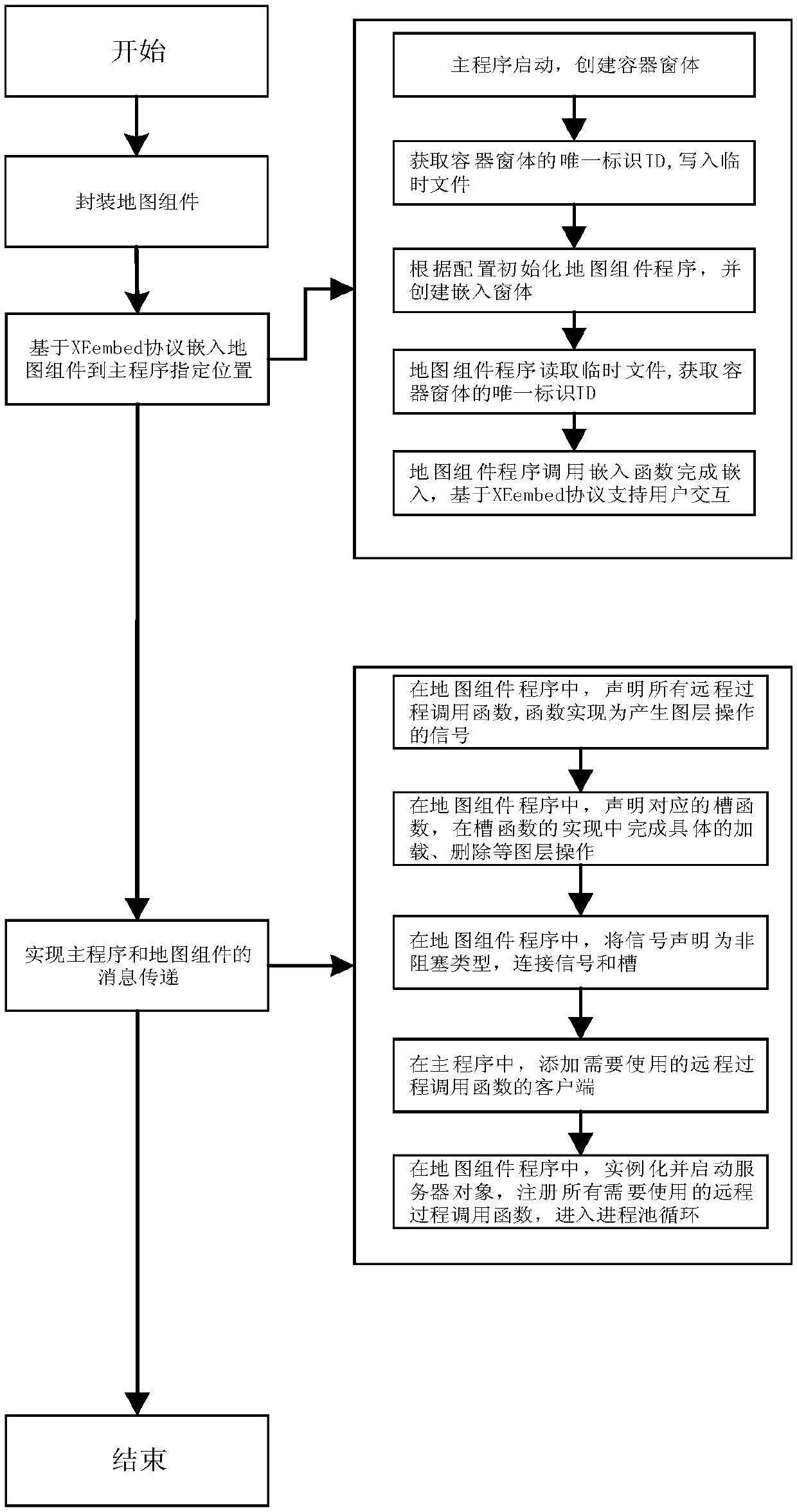
[0050] Specific embodiments of the present invention will be further described in detail below in conjunction with the accompanying drawings.

[0051] With the development of remote sensing technology, earth observation data has been applied in more and more fields. Scientific researchers need more convenient and faster tools for displaying spatial data and information. At present, there are already some geographic information library packages that can support interactive map display in desktop applications or web service programs. However, this type of method is usually a way of calling the API in the user's main program, which has various limitations such as complex use, high professional development knowledge requirements, and inability to dynamically and flexibly expand the program. Moreover, the interactive map function is limited by the package function of the class library, and only supports map display, but does not support extended functions such as spatial analysis,...


PUM


Abstract

The invention discloses an XEmbed-based interactive map component dynamic embedding method and system. The method comprises the following steps: firstly, pre-packaging a map component to become a configurable function and style independent program capable of being embedded into a window, then embedding the map component window into a main program based on an XEmbed protocol, and realizing basic user interaction operation by using an XEmbed protocol mechanism. designing a set of message transmission mechanism based on remote procedure call to support message transmission between the main program and the map component program, so that complete interaction of the map component is realized. A user can dynamically embed a map component in an existing application program of the user, seamlesslydisplay the map component at any specified position in a program interface, operate the map component and call related functions. The method is easy to implement, only configuration modification is needed, and extra programming work and professional geographic information system knowledge are not needed. And a simple, quick and novel method is provided for the user to realize the interactive map function in scientific research.

Description

technical field [0001] The invention relates to an XEmbed-based interactive map component dynamic embedding method and system, belonging to the technical field of geographic information systems. Background technique [0002] With the development of spacecraft and sensor technology, Earth observation data is increasing at an unprecedented rate. Massive data with spatial information can provide rich information resources for researchers in many disciplines, bringing great opportunities and new challenges. Researchers need more convenient and faster tools for displaying these geospatial data and resulting information. [0003] Researchers are often accustomed to developing their own customized scientific computing model algorithms for spatial data processing and analysis in the form of desktop applications. At present, there is a lack of such a method in this field, which can provide a lightweight, geospatial information display solution represented by an interactive map, and...

Claims


Application Information

Patent Timeline
Patent Type & Authority Applications(China)
IPC IPC(8): G06F8/38
CPCG06F8/38
Inventor 万伟兰穹穹郝雪涛
Owner CHINA CENT FOR RESOURCES SATELLITE DATA & APPL
Why Eureka
Try Eureka