GPS positioning system, GPS positioning method and GPS positioning terminal

A GPS positioning and positioning system technology, applied in the field of correcting radar measurement errors, can solve problems such as cumbersome operation procedures, inability of operators to achieve accurate calibration, difficulty in adapting to monitoring and deployment requirements, etc., and achieve the effect of reducing labor intensity

Inactive Publication Date: 2019-04-12
张科航
View PDF0 Cites 2 Cited by
  • Summary
  • Abstract
  • Description
  • Claims
  • Application Information

AI Technical Summary

Problems solved by technology

[0010] 2) The operation process is cumbersome
For example, in adverse weather conditions such as high cold and strong wind, the operator may not be able to achieve the purpose of accurate calibration due to his own reasons;
[0012] To sum up, this traditional method has many defects in the field of surveillance radar for rapid mobile deployment, and it is difficult to adapt to the rapidly developing surveillance deployment requirements.

Method used


Image

  • GPS positioning system, GPS positioning method and GPS positioning terminal
  • GPS positioning system, GPS positioning method and GPS positioning terminal
  • GPS positioning system, GPS positioning method and GPS positioning terminal

Examples


Embodiment Construction

[0032] The following will clearly and completely describe the technical solutions in the embodiments of the present invention with reference to the accompanying drawings in the embodiments of the present invention. Obviously, the described embodiments are only some, not all, embodiments of the present invention. Based on the embodiments of the present invention, all other embodiments obtained by persons of ordinary skill in the art without creative efforts fall within the protection scope of the present invention.

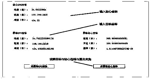
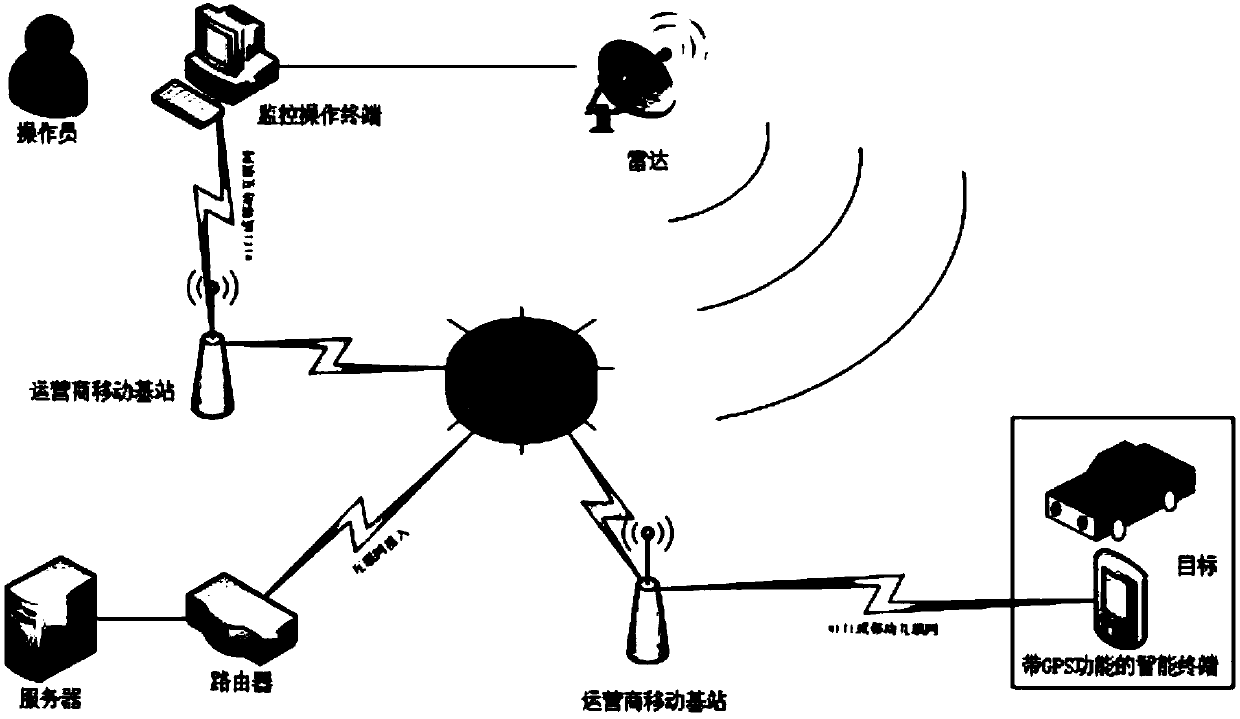
[0033] A smart terminal with GPS positioning function (such as a mobile phone) is pre-installed with a transfer APP to ensure that the network connection between the smart terminal and the radar operation terminal is normal, and the current geographic location of the smart terminal can be displayed on the radar monitoring operation terminal interface. Personnel or vehicles carry smart terminals to the remote end to cooperate with radar detection, so there are two fo...


PUM


Abstract

The invention relates to the technical field of a method for correcting a radar measurement error, and specifically discloses a GPS positioning system, a GPS positioning method and a GPS positioning terminal. A cooperative target performs pure radial movement to observe a declination of a plot detected by a radar and a GPS plot, wherein the declination is used for correcting an angle error. The delay of GPS plot transmission only has an error in the radial distance, and in this way, the error between 0 degrees of the radar and a true north angle can be accurately corrected. The cooperation target performs pure tangential movement to form two arcs taking a station center as an arc center at the interface of a radar monitoring and operation terminal. The distance difference between the two arcs is a radar distance error, which needs to be corrected. The delay of the GPS plot transmission only has front and back errors in the angle, and does not affect the correction of the radar distanceaccuracy. The invention has the advantage that the geodetic coordinate system and the radar coordinate system can be normalized through the personnel or other mobile carrier carrying the intelligentterminal pre-mounted with a transit APP, and the high-precision positioning and display of the target plot on the actual map is realized, so that the monitoring information output by the radar terminal is refined.

Description

technical field [0001] The invention relates to the technical field of methods for correcting radar measurement errors, in particular to a GPS positioning system, a GPS positioning method and a GPS positioning terminal. Background technique [0002] The result information of radar detection includes distance, angle, speed, etc. Generally, the focus is on the distance and azimuth of the target, that is, accurate positioning, and the determination of the target position and motion state. Therefore, the acquisition of azimuth and distance information is the main function of surveillance radar. [0003] Based on the principle of radar, there are certain systematic errors in the distance and angle information of the detected points; in addition, the installation error formed by the deviation angle between the mechanical zero position and the true north when the radar station is deployed will have a relatively large impact on the radar measurement accuracy. big impact. In partic...

Claims


Application Information

Patent Timeline
Patent Type & Authority Applications(China)
IPC IPC(8): G01S19/46G01S7/40
CPCG01S19/46G01S7/4004H04W4/025
Inventor 张科航
Owner 张科航
Why Eureka
Try Eureka