Precise Geomagnetic Surveying and Mapping System Based on Magnetometer and GPS and Its Geomagnetic Surveying and Mapping Method

A magnetometer and GPS positioning technology, applied in the field of surveying and mapping, can solve the problems of large search radius and poor accuracy of calculation results, and achieve the effects of accurate and reliable data, optimized accuracy, and improved sensitivity

Active Publication Date: 2020-07-24
NO 49 INST CHINESE ELECTRONICS SCI & TECH GRP
View PDF5 Cites 0 Cited by
  • Summary
  • Abstract
  • Description
  • Claims
  • Application Information

AI Technical Summary

Problems solved by technology

[0004] The purpose of the present invention is to solve the problem of large search radius and poor accuracy of calculation results in existing geomagnetic surveying and mapping methods, and to provide a precise geomagnetic surveying and mapping system based on magnetometer and GPS and its geomagnetic surveying and mapping method

Method used


Image

  • Precise Geomagnetic Surveying and Mapping System Based on Magnetometer and GPS and Its Geomagnetic Surveying and Mapping Method
  • Precise Geomagnetic Surveying and Mapping System Based on Magnetometer and GPS and Its Geomagnetic Surveying and Mapping Method

Examples


specific Embodiment approach 1

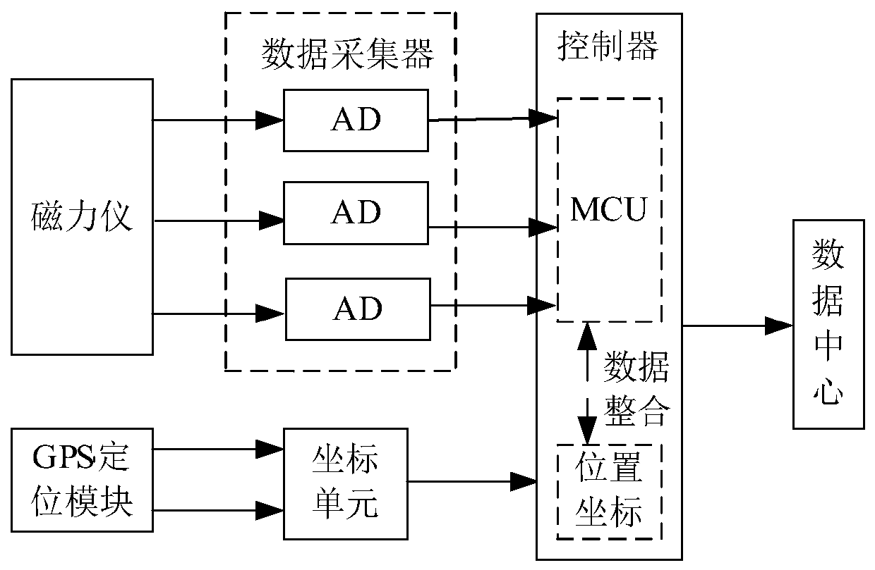
[0035] Specific implementation mode one: the following combination figure 1 Describe this embodiment, the precision geomagnetic surveying and mapping system based on magnetometer and GPS described in this embodiment, this surveying and mapping system comprises magnetometer, data collector, GPS positioning module, coordinate unit, controller and data center;

[0036] The magnetometer detects the geomagnetic field information;

[0037] The data collector collects the geomagnetic field information detected by the magnetometer, and transmits the geomagnetic field information to the controller;

[0038] The GPS positioning module acquires the measurement position information synchronously;

[0039] The coordinate unit converts the position information measured by the GPS positioning module into position coordinates, and sends the position coordinates to the controller;

[0040] The controller integrates the geomagnetic field information and position coordinates, and transmits the...

specific Embodiment approach 2

[0047] Embodiment 2: In this embodiment, Embodiment 1 is further described. The geomagnetic field information detected by the magnetometer is three-axis geomagnetic information.

specific Embodiment approach 3

[0048] Specific implementation mode three: the following combination figure 1 The present embodiment is described, and the second embodiment is further described in this embodiment. The data collector adopts three-way AD analog-to-digital converters to collect three-axis geomagnetic field information.


PUM


Abstract

The invention discloses a precise geomagnetic surveying and mapping system based on a magnetometer and a GPS (Global Positioning System), and a geomagnetic surveying and mapping method thereof, belongs to the technical field of surveying and mapping, and aims to solve the problems of large search radius and poor calculation result accuracy of an existing geomagnetic surveying and mapping method. The system comprises a magnetometer, a data collector, a GPS positioning module, a coordinate unit, a controller and a data center, wherein the magnetometer detects geomagnetic field information; the data collector collects the geomagnetic field information detected by the magnetometer, and transmits the geomagnetic field information to the controller; the GPS positioning module synchronously obtains measurement position information; the coordinate unit converts the position information measured by the GPS positioning module into a position coordinate, and sends the position coordinate to the controller; the controller carries out data integration on the geomagnetic field information and the position coordinate, and transmits the integrated geomagnetic data to the data center; and the datacenter receives the integrated geomagnetic data, and draws a geomagnetic graph by taking the geomagnetic data as a benchmark to finish surveying and mapping. The system is used for the precise surveying and mapping of geomagnetism.

Description

technical field [0001] The invention relates to a precision surveying and mapping system under a geomagnetic background, belonging to the technical field of surveying and mapping. Background technique [0002] As an extremely important physical field, the geomagnetic field has been widely used in matching navigation, micro-orbit determination, anomaly detection and environmental prediction and other fields. On the one hand, the geomagnetic field model can provide the spatial distribution rules of the earth’s interior materials, provide a basis for the detection of matter and minerals in the earth’s crust, and can also predict natural disasters such as earthquakes that cause geomagnetic changes; on the other hand, according to the vector component of the geomagnetic field Information can be applied to navigation fields such as guidance control, underwater matching navigation, and aerospace technology. [0003] The research on geomagnetic surveying and mapping includes resear...

Claims


Application Information

Patent Timeline
Patent Type & Authority Patents(China)
IPC IPC(8): G01V3/40G01C21/08
CPCG01C21/08G01V3/40
Inventor 毕佳宇王辉王珺琳桂永雷孙立凯宋尔冬沈广楠
Owner NO 49 INST CHINESE ELECTRONICS SCI & TECH GRP
Why Eureka
Try Eureka