A differential positioning system for satellite navigation and an implementation method thereof

A differential positioning and satellite navigation technology, which is applied in the field of satellite navigation, can solve the problems that the differential enhanced information cannot be judged, and the mobile station equipment cannot receive it, so as to reduce the environmental requirements, prevent data forgery, and improve security.

Active Publication Date: 2019-05-10
潍坊同达电子科技有限公司
9 Cites 4 Cited by

AI-Extracted Technical Summary

Problems solved by technology

[0005] Aiming at various deficiencies in the prior art, the purpose of the present invention is to provide a differential positioning system for satellite navigation and its implementation method, which solves the problems in the prior ...

Method used

A kind of differential positioning system and its implementation method for satellite navigation provided by the present invention, the device configured on base station equipment and mobile equipment is all equipped with the GPRS modul...

Abstract

The invention discloses a differential positioning system for satellite navigation, which comprises base station equipment, a cloud server and mobile station equipment. the base station equipment is used for calculating differential enhancement information in real time, receiving a differential enhancement service application of the mobile station equipment and verifying the legality of the service application; The mobile station equipment applies for service from the base station equipment, verifies the validity of service response, and performs differential positioning settlement by using the differential enhancement information; And the cloud server is responsible for data transmission between the base station equipment and the mobile station equipment. The base station equipment and the mobile station equipment in the device are both equipped with the GPRS data communication modules, and the GPRS data communication modules and the mobile station equipment carry out information interaction through the cloud server by utilizing the mobile communication network, so that system data communication is not influenced by sight distance transmission any more, the requirement of system work on the environment is greatly reduced, and the safety of the whole system is improved.

Application Domain

Technology Topic

Image

  • A differential positioning system for satellite navigation and an implementation method thereof
  • A differential positioning system for satellite navigation and an implementation method thereof
  • A differential positioning system for satellite navigation and an implementation method thereof

Examples

  • Experimental program(1)

Example Embodiment

[0042] The technical solutions in the embodiments of the present invention will be clearly and completely described below in conjunction with the accompanying drawings in the embodiments of the present invention. Obviously, the described embodiments are only a part of the embodiments of the present invention, rather than all the embodiments. Based on the embodiments of the present invention, all other embodiments obtained by those of ordinary skill in the art without creative work shall fall within the protection scope of the present invention.
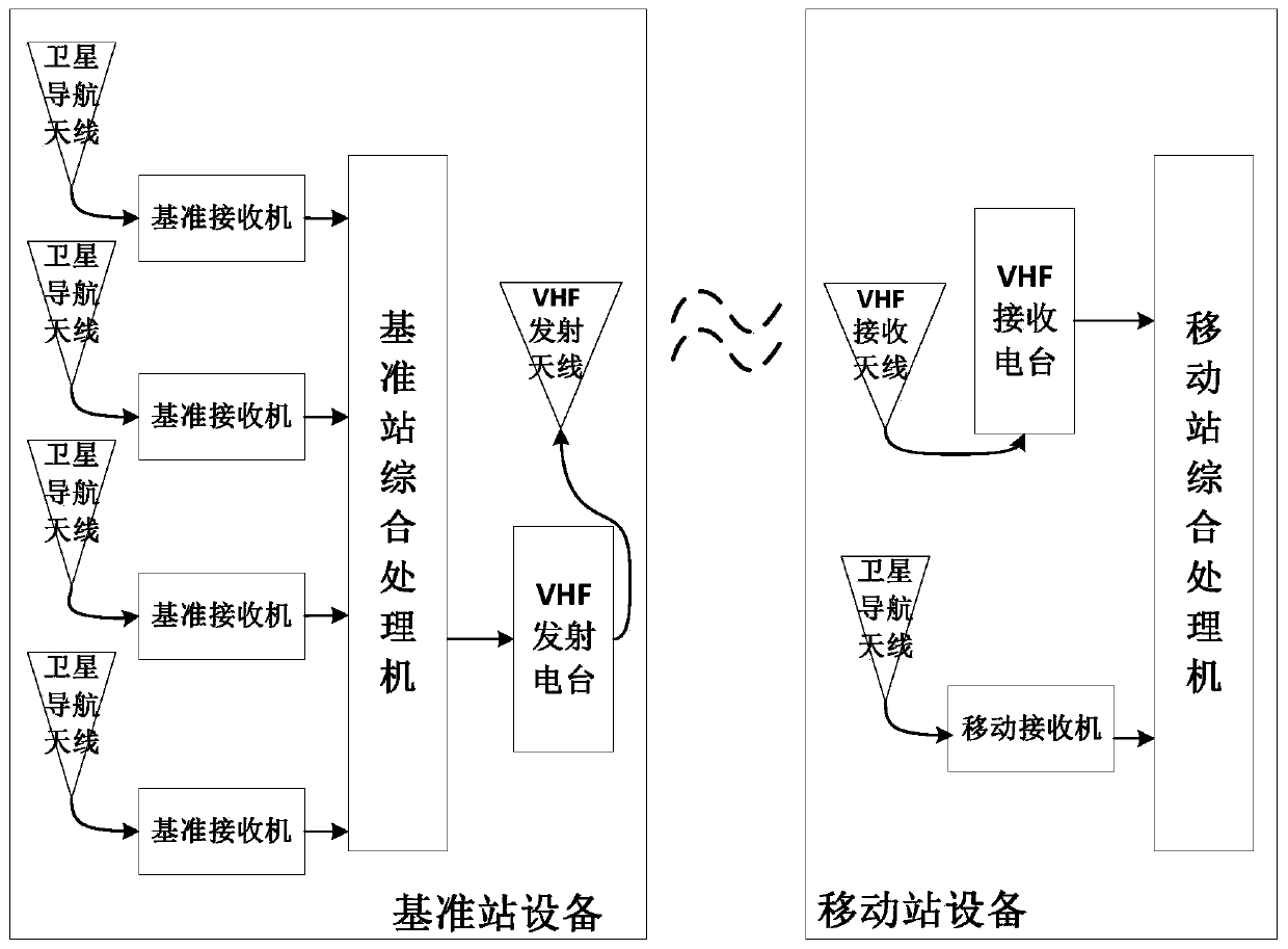
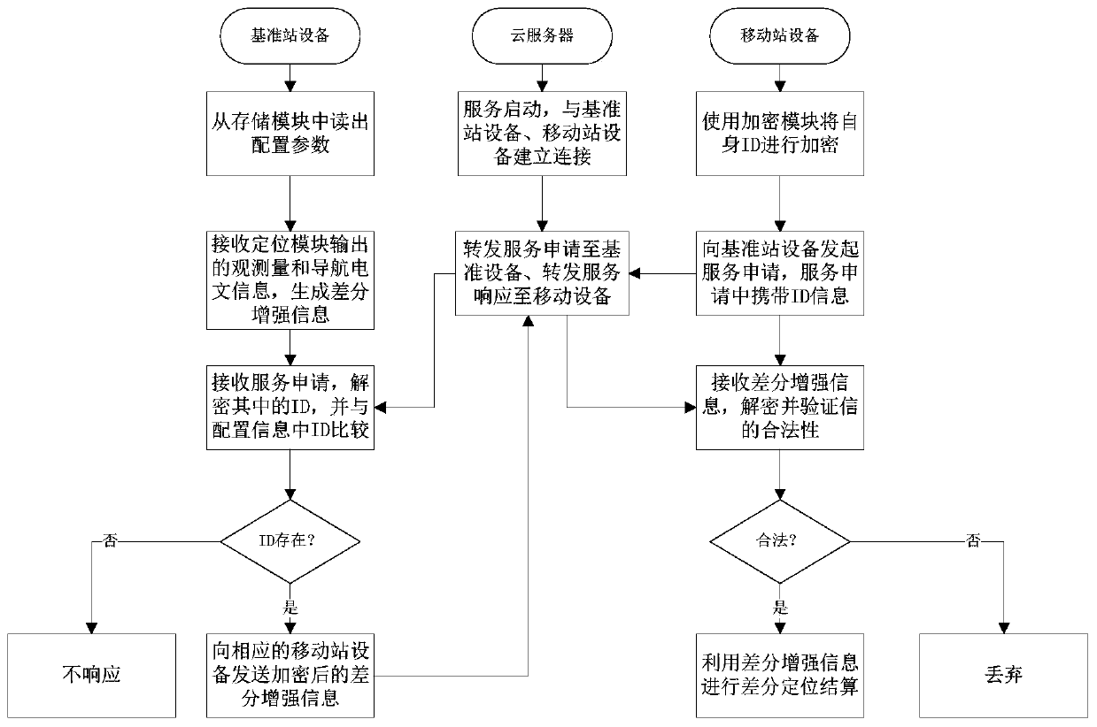
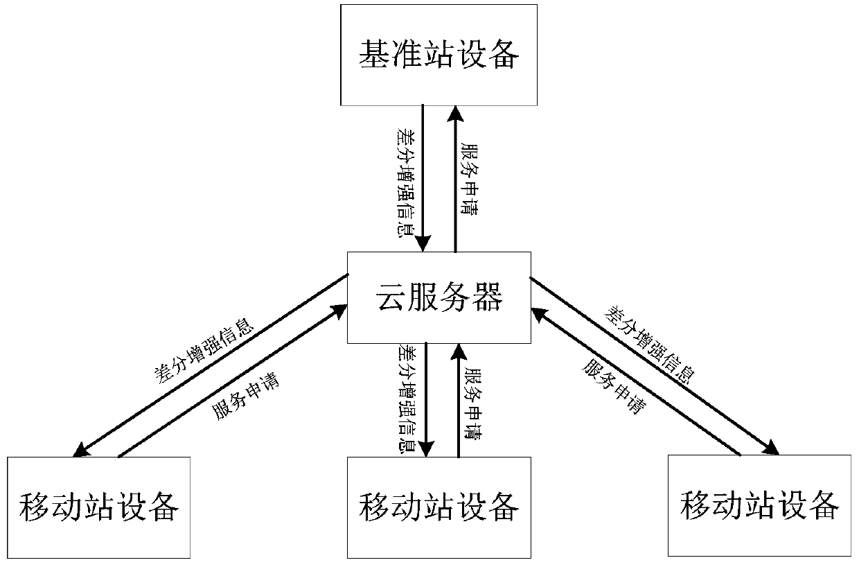
[0043] This embodiment provides a differential positioning system for satellite navigation, such as Figure 2-3 Shown, including base station equipment, cloud server and mobile station equipment.
[0044] The reference station equipment is used to calculate the differential enhancement information in real time and receive the differential enhancement service application of the mobile station equipment, and verify the legality of the service application;
[0045] The mobile station device applies for a service from the reference station device, verifies the legality of the service response, and uses differential enhancement information for differential positioning settlement;
[0046] The cloud server is responsible for data transmission between the base station equipment and the mobile station equipment.
[0047] Such as Figure 4 As shown, it is the main connection method of the reference station. The reference station equipment includes: PowerPC-T1042 processor, PSAM consumer safety certification module, GBM-DD103 (GPS/BDS) positioning module and satellite navigation antenna, MC8630 (GPRS) communication module And GPRS antenna, ATMEL24C64 (EEPROM) storage module. Among them: GBM-DD103 positioning module connects with PowerPC-T1042 processor through UART1 asynchronous transmitter and receiver, and receives satellite signals through satellite navigation antenna; MC8630 communication module connects with PowerPC-T1042 processor through UART2 asynchronous transmitter and receiver and through GPRS antenna Send and receive data; the PSAM consumer security authentication module is connected to the PowerPC-T1042 processor through the 7816 bus interface and is responsible for data encryption and decryption; the ATMEL24C64 storage module is connected to the PowerPC-T1042 processor through the IIC interface to store configuration parameters.
[0048] When in use, the upper computer first writes the configuration parameters into the storage module through the RS232 serial port. The configuration parameters include the precise coordinates of the satellite navigation antenna of the base station equipment and the ID information of the legal mobile station equipment. The positioning module receives satellite signals through the satellite navigation antenna and generates observation information and navigation messages, which are sent to the processor through the UART1 interface. The processor uses the received observation information, navigation messages, and antenna coordinates in the configuration parameters to generate differential enhancement information in real time, and sends the information to the PSAM consumer safety certification for encryption. The processor receives the service application of the mobile station equipment through the communication module and the GPRS antenna, determines the legality of the ID information of the service application, and sends the encrypted differential enhanced information to the mobile station equipment with legal ID information.
[0049] Such as Figure 5 Shown are the main internal components and connection methods of the mobile station equipment. The mobile station equipment includes PowerPC-T1042 processor, PSAM consumer safety certification module, GBM-DD103 (GPS/BDS) positioning module and satellite navigation antenna, MC8630 (GPRS) communication Module and GPRS antenna. Among them, the GBM-DD103 positioning module is connected to the PowerPC-T1042 processor through the UART1 asynchronous transmitter and receiver and receives satellite signals through the satellite navigation antenna; the MC8630 communication module is connected to the PowerPC-T1042 processor through the UART2 asynchronous transmitter and receiver and transmits and receives data through the antenna ; The PSAM module is connected to the PowerPC-T1042 processor through the 7816 bus interface and is responsible for data encryption and decryption.
[0050] When in use, the positioning module receives satellite signals through the satellite navigation antenna, and generates observation information and navigation messages, which are sent to the processor through the UART1 asynchronous transceiver interface; the processor sends service applications to the reference station equipment through the communication module and GPRS antenna, And receive the differential incremental information in the service response, and then combine the observations and navigation messages for differential positioning settlement.
[0051] A method for implementing a differential positioning system for satellite navigation includes the following steps:
[0052] S1: The cloud server is powered on and connected to the base station equipment and mobile station equipment at the same time.
[0053] S2: The reference station equipment uses the signal output by the positioning module to combine with the coordinate information of the satellite navigation antenna configured in the storage module to calculate and generate differential enhancement information in real time.
[0054] S3: The mobile station device uses the PSAM consumer security authentication module to encrypt its own ID information, and initiates a service application to the cloud server (the service application carries the encrypted ID information).
[0055] S4: After the cloud server receives the service application from the mobile station device, it carries the encrypted ID information and forwards it to the base station device.
[0056] S5: After the base station device receives the service application from the cloud server, it uses the PSAM consumer security authentication module to decrypt the encrypted ID information in the service application to obtain the mobile station device ID information; and the mobile station device ID information and configuration parameters The ID information stored in the comparison; if it exists, it is determined that the mobile station equipment is legal, otherwise it does not respond.
[0057] S6: The reference station equipment uses the PSAM consumer security authentication module to encrypt the differential enhanced information, and sends the encrypted differential enhanced information to the cloud server.
[0058] S7: The cloud server receives the encrypted differential enhancement information from the base station equipment, and directly forwards it to the corresponding legal mobile station equipment.
[0059] S8: The mobile station device receives the encrypted differential enhanced information, uses the PSAM consumer security authentication module to decrypt it, and judges the legality of the decrypted information, if it is legal, the information is used for differential positioning settlement, otherwise it is discarded.
[0060] At the same time, the configuration parameters include the coordinates of the satellite navigation antenna of the base station equipment and the legal mobile station equipment ID information.
[0061] Preparation before system work:
[0062] 1. The base station equipment and mobile station equipment are equipped with PSAM security authentication module, and the same key should be injected into the module before use.
[0063] 2. Use the host computer to configure the parameters of the base station equipment. The configured parameters include the precise coordinates of the base station equipment satellite navigation antenna and the legal mobile station equipment ID. After the base station equipment receives these configuration parameters, it stores them in the storage module for backup.
[0064] The present invention provides a differential positioning system for satellite navigation and its implementation method. The devices configured on the reference station equipment and mobile equipment are equipped with a GPRS module for data transmission and a PSAM consumer safety certification for encryption and decryption. Module. The system can reduce the dependence of data transmission on the environment, and can ensure the security of data interaction.
[0065] The invention has been described in detail above. The above are only preferred embodiments of the present invention. When the scope of implementation of the present invention cannot be limited, all changes and modifications made in accordance with the scope of the present application shall still belong to the present invention. Covered.

PUM

no PUM

Description & Claims & Application Information

We can also present the details of the Description, Claims and Application information to help users get a comprehensive understanding of the technical details of the patent, such as background art, summary of invention, brief description of drawings, description of embodiments, and other original content. On the other hand, users can also determine the specific scope of protection of the technology through the list of claims; as well as understand the changes in the life cycle of the technology with the presentation of the patent timeline. Login to view more.

Similar technology patents

Tunnel robot composite communicating system

Owner:GUANGZHOU POWER SUPPLY BUREAU GUANGDONG POWER GRID CO LTD

Classification and recommendation of technical efficacy words

  • Low environmental requirements
  • Prevent data falsification
Why Eureka
Try Eureka