
Map-based ground taxing guidance system

A ground taxiing and guidance system technology, applied in the direction of aircraft ground control, etc., can solve the problem that the safety and efficiency of taxiing cannot be effectively guaranteed, and achieve the effect of reducing runway intrusion and improving surveillance capabilities

Inactive Publication Date: 2019-05-14
CHINESE AERONAUTICAL RADIO ELECTRONICS RES INST
View PDF4 Cites 10 Cited by
  • Summary
  • Abstract
  • Description
  • Claims
  • Application Information

AI Technical Summary

Problems solved by technology

[0011] The purpose of the present invention is to provide a map-based ground taxiing guidance system to solve the problem in the prior art that the flight crew is in a passive position and the safety and efficiency of taxiing cannot be effectively guaranteed

Method used


Image

  • Map-based ground taxing guidance system

Examples


Embodiment Construction

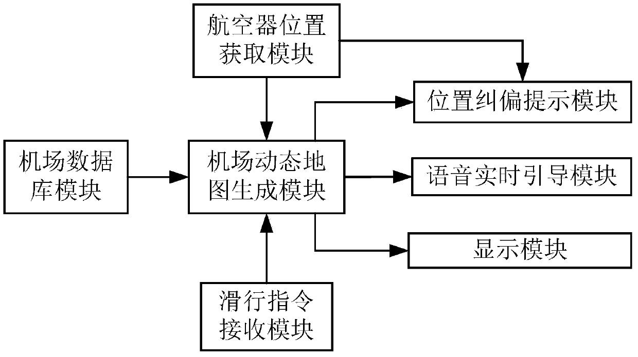
[0026] see figure 1 Shown is a schematic block diagram of the composition of the map-based ground taxiing guidance system of the present invention. Implementation of the map-based ground taxiing guidance system of the present invention includes the following modules:

[0027] The airport database module is used to store the terrain conditions of the airport and the spatial layout information of each component of the airport;

[0028] The aircraft position obtaining module is used to obtain the position information of the aircraft itself and other aircraft on the airport;

[0029] Taxi instruction receiving module, used to receive the taxi instruction issued by the airport;

[0030] The airport dynamic map generation module is used to dynamically generate a real-time map of the airport according to the information of the airport database module and the aircraft position acquisition module, and generate an estimated taxi path on the real-time map of the airport according to th...


PUM


Abstract

The invention discloses a map-based ground taxing guidance system. The system comprises an airport database module used for storing terrain conditions of an airport and spatial layout information of all components of the airport, an aircraft position acquisition module used for acquiring position information of an aircraft and other aircrafts on the airport, a taxing instruction receiving module used for receiving a taxing instruction issued by the airport, an airport dynamic map generating module used for dynamically generating a real-time map of the airport according to the information of the airport database module and the aircraft position acquisition module and generating a predicted taxing path on the real-time map of the airport according to the taxing instruction received by the taxing instruction receiving module, and a display module used for displaying the real-time map of the airport and the predicted taxing path formed by the airport dynamic map generating module.

Description

【Technical field】 [0001] The invention belongs to the field of aviation operation management, in particular to a map-based ground taxiing guidance system. 【Background technique】 [0002] The airport pavement is the area with the highest density of aircraft operations. Statistics show that this area is also an area with a high incidence of aviation accidents. The worst air accident in the history of aviation shows that aircraft errors during taxiing are likely to lead to catastrophic consequences. Therefore, the safety and efficiency of aircraft taxiing on airport pavement have always been the focus of global navigation. In recent years, with the continuous increase of flight flow and the number of airports and airport runways, unsafe accidents and accident symptoms such as runway incursions, aircraft skidding, taxiway conflicts, and dangerous approach between aircraft and airport vehicles have occurred frequently. [0003] Currently, paper airport maps are the main referenc...

Claims


Application Information

Patent Timeline
Patent Type & Authority Applications(China)
IPC IPC(8): G08G5/06
Inventor 徐海玉张晶磊
Owner CHINESE AERONAUTICAL RADIO ELECTRONICS RES INST
Learn More