Desert bush coverage unmanned aerial vehicle survey method

A technology for unmanned aerial vehicles and shrubs, applied in three-dimensional position/channel control and other directions, can solve the problems of sparse distribution of shrubs, and achieve the effect of reasonable method, saving field investigation time, and good promotion and application prospects.

Inactive Publication Date: 2019-05-17
TIANJIN RES INST FOR WATER TRANSPORT ENG M O T
View PDF11 Cites 8 Cited by
  • Summary
  • Abstract
  • Description
  • Claims
  • Application Information

AI Technical Summary

Problems solved by technology

However, due to the relatively poor soil and water conditions in the desert, the distribution of shrubs is relatively sparse; therefore, traditional desert shrub cover surveys require a large sample plot on site to make the survey results representative, such as 20m×20m, or even 50m× 50m

Method used


Image

  • Desert bush coverage unmanned aerial vehicle survey method
  • Desert bush coverage unmanned aerial vehicle survey method
  • Desert bush coverage unmanned aerial vehicle survey method

Examples


Embodiment Construction

[0023] The present invention will be further described below in conjunction with the accompanying drawings and specific embodiments, but the following embodiments in no way limit the present invention.

[0024] The following is a detailed description of the specific implementation process of the UAV survey method for the coverage of desert shrubs in this application, taking the desert shrubs such as pigskin, Nitraria, and Haloxylon in Delingha Suo Forest Nature Reserve in Qinghai Province as examples. .

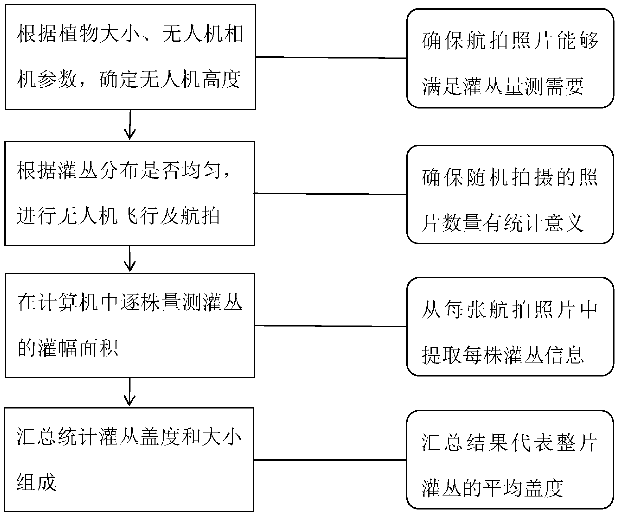
[0025] like figure 1 As shown, the specific implementation steps of the UAV survey method for desert shrub coverage are as follows:

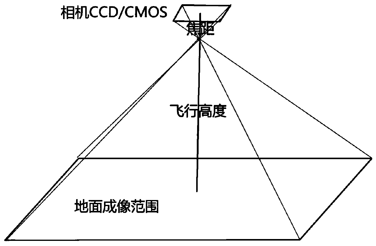
[0026] Step 1. Control the UAV to fly to multiple random locations in the desert bushes, and use the airborne camera to capture multiple photos of the bushes with the lens vertically downward at a suitable flying height; The photos of shrubs mentioned above should be photos of shrubs with various distribution characteristics; specifically,

...


PUM


Abstract

The invention discloses a desert bush coverage unmanned aerial vehicle survey method which is implemented sequentially by three steps of: S1, controlling an unmanned aerial vehicle to fly to a plurality of random positions of desert bushes and acquire a plurality of bush photos with various distribution characteristics in a shooting mode that a lens is vertically downward; S2, manually draw an outline of each plant of bush in each photo by utilizing photo editing software of a computer, and carrying out statistics on a number of pixels included in each drawn outline so as to calculate a crownarea of each plant of bush; and S3, by calculating a corresponding bush area and desert coverage range in each photo, calculating a bush coverage of a desert region related to all the photos. The desert bush coverage unmanned aerial vehicle survey method is reasonable, simple and easy to operate, can save a great amount of field survey time and has good popularization and application prospect.

Description

technical field [0001] The invention relates to the technical field of desert shrub cover survey, in particular to an unmanned aerial vehicle survey method for desert shrub cover. Background technique [0002] The desert is located between the desert and the grassland, and is very fragile. If it is not well protected, it will degenerate into a desert, and if it is well protected, it will be the frontier of desert governance. Therefore, the growth of desert shrubs has become an important indicator reflecting the ecological conditions of deserts, and the coverage of desert shrubs is an important indicator. If water and soil conditions are improved, the coverage will increase, and vice versa, the coverage will decrease. However, due to the relatively poor soil and water conditions in the desert, the distribution of shrubs is relatively sparse; therefore, traditional desert shrub cover surveys require a large sample plot on site to make the survey results representative, such a...

Claims


Application Information

Patent Timeline
Patent Type & Authority Applications(China)
IPC IPC(8): G05D1/10
Inventor 胡健波彭士涛黄伟熊红霞
Owner TIANJIN RES INST FOR WATER TRANSPORT ENG M O T
Why Eureka
Try Eureka