Rapid modeling method for 3DGIS terrain model based on CASS and CATIA

A modeling method and terrain model technology, applied in the field of 3D geographic information survey, can solve problems such as low efficiency, difficult promotion, and high cost of 3D laser scanning, and achieve the effect of shortening time and improving modeling efficiency

Active Publication Date: 2019-06-07
四川汶马高速公路有限责任公司 +2
View PDF3 Cites 4 Cited by
  • Summary
  • Abstract
  • Description
  • Claims
  • Application Information

AI Technical Summary

Problems solved by technology

As far as the current stage is concerned, there are mainly the following methods for obtaining 3D terrain data: on-site measurement is the current mainstream data acquisition method, but the efficiency is low; based on orthophoto maps, digital differential correction and mosaic are performed on aerial images, and according to a certain map The digital orthophoto image generated by clipping a wide range has both map geometric accuracy and image characteristics. At present, the development of UAV technology is mature, and the orthophoto map obtained by UAV is currently a priority for many large-area construction project surveys. Technical means: Based on the 3D scanning point cloud, it is the most accurate of the three basic data acquisition methods, but the cost of 3D laser scanning is expensive, which is also the reason for the difficulty in large-scale promotion at present

Method used


Image

  • Rapid modeling method for 3DGIS terrain model based on CASS and CATIA
  • Rapid modeling method for 3DGIS terrain model based on CASS and CATIA
  • Rapid modeling method for 3DGIS terrain model based on CASS and CATIA

Examples


Embodiment Construction

[0039] In order to make the object, technical solution and advantages of the present invention clearer, the present invention will be further described in detail below in conjunction with the accompanying drawings and specific embodiments. The specific embodiments described here are only used to explain the present invention, not to limit the invention.

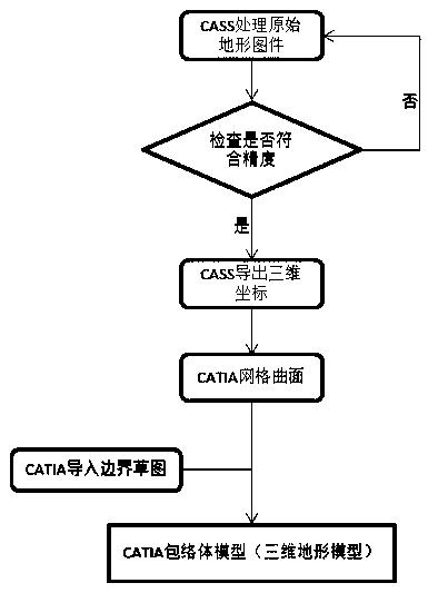
[0040] Such as figure 1 Shown, a kind of 3DGIS terrain model rapid modeling method based on CASS and CATIA of the present embodiment comprises the following steps:

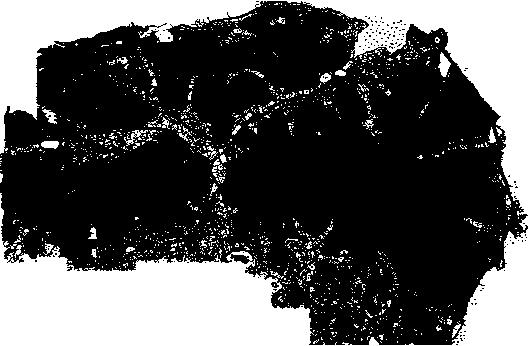
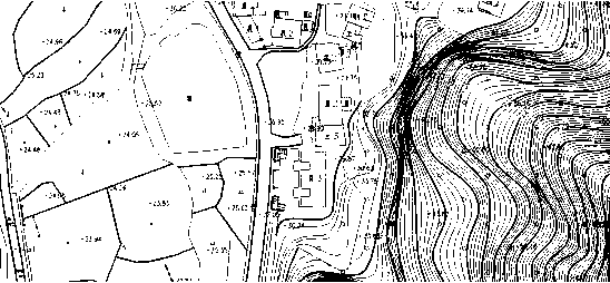
[0041] Firstly, sort and classify the collected survey drawings, and combine different drawings into one DWG file in CAD, as shown in the attached figure 2 , image 3 said;

[0042] Open the sorted drawings in the CASS software, and select the four views of "front, back, left, and right" in the three-dimensional view, that is, based on Figure 5 As mentioned above, select the line and point data with abnormal elevation in turn, and delete them;

[0043]For ...


PUM


Abstract

The invention discloses a 3DGIS terrain model rapid modeling method based on CASS and CATIA, and the method comprises the steps: firstly processing an original terrain map in CASS software, and removing unnecessary geometric figures and non-geometric figure blocks in the original terrain map; then respectively extracting elevation annotation points and X\ Y\ Z coordinate values with attribute values in the contour line object; and importing the three-dimensional coordinate data into CATIA software to quickly establish a three-dimensional terrain model conforming to the precision. According tothe method, topographic three-dimensional coordinates are rapidly and accurately extracted from an original topographic survey map, and a BIM entity topographic model is established and used for constructing an engineering project decision-making stage to an operation and maintenance full life cycle; the problems that terrain data are difficult to obtain, precision is low, the three-dimensional terrain modeling speed is low, and the construction engineering field and geographic information are combined (3DGIS) are well solved.

Description

technical field [0001] The invention relates to the technical field of three-dimensional geographic information survey, in particular to a method for quickly modeling a 3DGIS terrain model based on CASS and CATIA. Background technique [0002] Three-dimensional GIS (3DGIS) technology is an inevitable trend in the development of geographic information systems today, because in addition to expressing two-dimensional information, it can also describe three-dimensional spatial information content. As more and more BIM technologies are applied in basic design and construction, More technical researchers are focusing on the integrated application of Building Information Modeling (BIM) and Geographic Information System (GIS). GIS technology can just make up for the shortcomings of traditional BIM software in infrastructure construction in a large-scale environment. BIM technology refers to the visual digital building model (Building Information Modeling, referred to as BIM) constru...

Claims


Application Information

Patent Timeline
Patent Type & Authority Applications(China)
IPC IPC(8): G06T17/05G06T17/20
CPCY02A90/10
Inventor 李永林牟力李斌张文居彭森林孙家升范存磊莫飞魏厚超徐振孙义军
Owner 四川汶马高速公路有限责任公司
Why Eureka
Try Eureka