Multi-temporal remote sensing image city vegetation extraction method based on a neural network

A technology of remote sensing images and neural networks, applied in the direction of instruments, character and pattern recognition, computer components, etc., can solve the problems of automatic recognition of urban vegetation, affect the stability of recognition, etc., and achieve good accuracy and good practicability Effect

Inactive Publication Date: 2019-06-11
SUZHOU IND PARK SURVEYING MAPPING & GEOINFORMATION CO LTD +1
View PDF2 Cites 4 Cited by
  • Summary
  • Abstract
  • Description
  • Claims
  • Application Information

AI Technical Summary

Problems solved by technology

However, due to the inclination angle of satellite remote sensing photography, buildings in cities usually cover green spaces in satellite

Method used


Image

  • Multi-temporal remote sensing image city vegetation extraction method based on a neural network
  • Multi-temporal remote sensing image city vegetation extraction method based on a neural network
  • Multi-temporal remote sensing image city vegetation extraction method based on a neural network

Examples


Embodiment 1

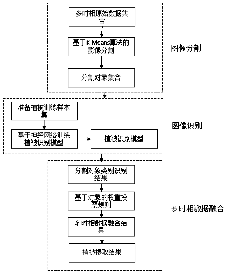
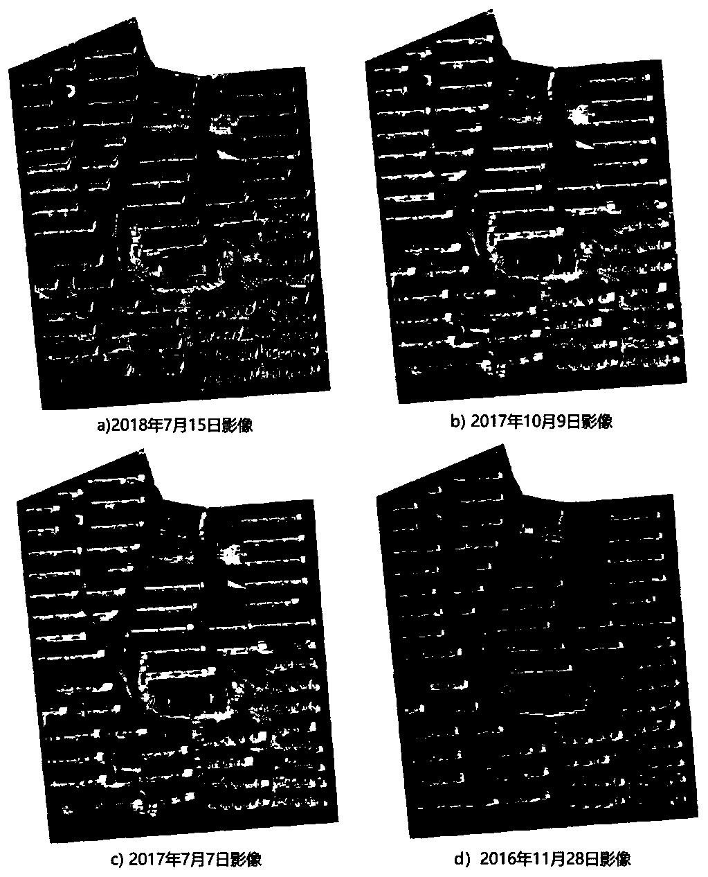
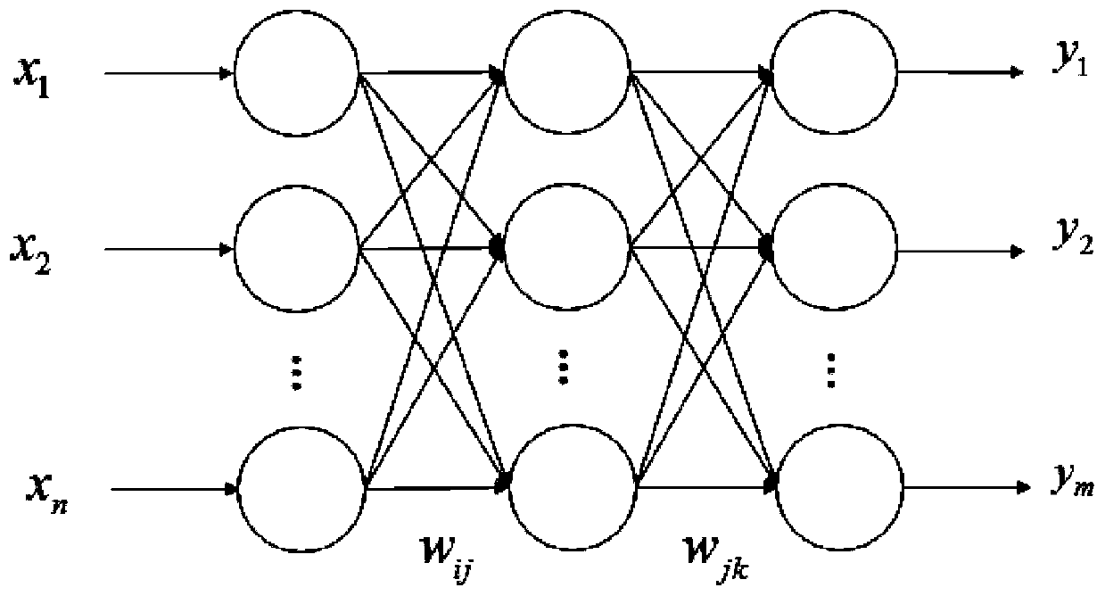
[0046] The flow diagram of a method for extracting urban vegetation from multi-temporal remote sensing images based on neural networks is as follows: figure 1 shown. Depend on figure 1 It can be seen that the vegetation extraction process is divided into three parts. The first part is the image segmentation stage. Its purpose is to divide the multi-temporal remote sensing image data into multiple objects, and use the objects to extract and identify vegetation, which is conducive to the fusion of multi-feature factors. . The segmentation method adopts the K-means clustering method. The advantage of this method is that there is no need to set segmentation parameters, and it has good segmentation adaptability; the second part is to use the BP neural network model to identify the segmented objects, mainly It uses artificial training samples to build a neural network vegetation recognition model; the third part is to perform multi-temporal data fusion on the extraction results of...


PUM


Abstract

The invention discloses a multi-temporal remote sensing image city vegetation extraction method based on a neural network, and belongs to the technical field of vegetation extraction, and the method comprises the steps: carrying out the image segmentation of an image based on multi-temporal high-resolution remote sensing image data; training the training sample by using a BP neural network methodto form a neural network model for experimental region vegetation; and carrying out vegetation extraction on the multi-temporal data by using the model, and fusing a multi-temporal extraction result by using a voting rule based on a weight so as to obtain a vegetation region with higher precision. When the method is used for extracting the vegetation in the residential area, the extraction precision is improved from 87.6% to 93.3%, and the method has good practicability. The method is applicable to vegetation extraction of other areas such as residential areas, commercial areas and industrialareas in actual work, and can be popularized to vegetation coverage research work of a whole city.

Description

technical field [0001] The invention belongs to the technical field of vegetation extraction, in particular to a neural network-based multi-temporal remote sensing image urban vegetation extraction method. Background technique [0002] With the development of remote sensing sensor technology, high spatial resolution remote sensing images play an increasingly important role in the automatic extraction of urban ground features. How to more effectively extract the required roads, vegetation, buildings and other features from remote sensing images is an important task in the field of remote sensing. [0003] Vegetation coverage measurement in residential areas is an important and routine task in current surveying and mapping work. Traditional manual surveying and mapping requires surveying and mapping operators to conduct on-site surveys, while in-house manual interpretation based on satellite remote sensing images or aerial images is also It is time-consuming and labor-intensi...

Claims


Application Information

Patent Timeline
IPC IPC(8): G06K9/00G06K9/34G06K9/62
Inventor 钱程扬张琪蒋如乔
Owner SUZHOU IND PARK SURVEYING MAPPING & GEOINFORMATION CO LTD
Why Eureka
Try Eureka