A method and device for generating a high-precision map

A high-precision, map technology, used in image enhancement, image analysis, image data processing, etc., can solve the problems of inability to achieve high-precision centimeters, high cost, and large errors.

Active Publication Date: 2019-06-14
HANGZHOU FABU TECH CO LTD
View PDF4 Cites 33 Cited by
  • Summary
  • Abstract
  • Description
  • Claims
  • Application Information

AI Technical Summary

Problems solved by technology

[0003]Usual high-precision map solutions rely on high-precision GPS and inertial measurement unit (IMU) integrated navigation systems with RTK (Real-Time Kinematic, real-time dynamic positioning), But its cost is too expensive. At the same time, in the environment with weak or no signal such as high-rise buildings, tunnels, underground garages, etc., or when the vehicle turns sharply, shakes, or in bad weather, the error will become so large that it is far from being able to achieve high-precision centimeters. (cm) level requirements

Method used


Image

  • A method and device for generating a high-precision map
  • A method and device for generating a high-precision map
  • A method and device for generating a high-precision map

Examples


Embodiment Construction

[0027] Preferred embodiments of the present disclosure will be described in more detail below with reference to the accompanying drawings. Although preferred embodiments of the present disclosure are shown in the drawings, it should be understood that the present invention can also be implemented in various other forms and should not be limited to the specific embodiments described below. These specific embodiments are provided here to make the disclosure of the present invention more thorough and complete, and to fully convey the scope of the disclosure of the present invention to those skilled in the art.

[0028] The word "exemplary" is used herein to mean "serving as an example, illustration, or illustration." Any aspect described herein as "exemplary" should not be construed as preferred or advantageous over other aspects.

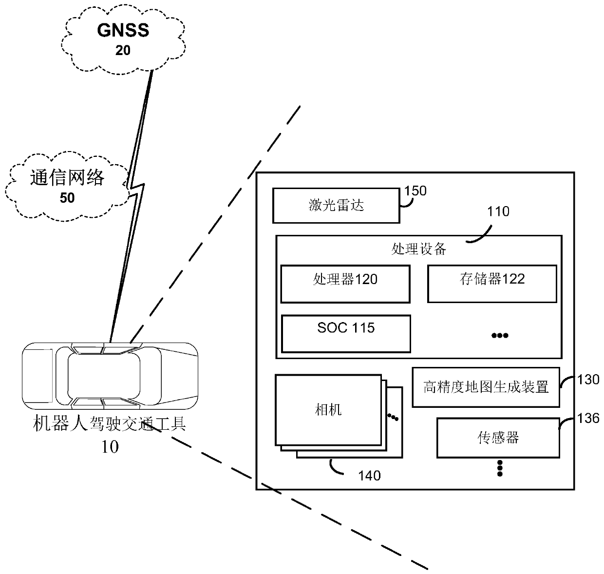
[0029] As used herein, the terms "robotically driven vehicle" and "drones" and "unmanned vehicles" refer to various types of vehicles including on-b...


PUM


Abstract

The invention discloses a method and a device for generating a high-precision map without relying on RTK (Real Time Kinematic). The method comprises the following steps: acquiring picture data from acamera; acquiring point cloud data from the laser radar; acquiring attitude information from a Global Navigation Satellite System (GNSS)/Inertia Measurement Unit (IMU); processing the picture data toextract visual feature information, and performing pose estimation according to the visual feature information extracted from the current frame, previously fused overall pose information and previously maintained map visual feature information to obtain camera pose estimation; processing the point cloud data to obtain point cloud information, and performing attitude estimation according to the point cloud information and other information to obtain radar attitude estimation; fusing the attitude information, the camera attitude estimation and the radar attitude estimation to obtain a more accurate and stable attitude estimation result; and according to a more accurate and stable attitude estimation result, fusing the picture data and the point cloud data to construct a high-precision map.

Description

technical field [0001] Generally speaking, the present invention relates to the field of automatic driving, and in particular, relates to a method and device for generating high-precision maps and positioning based on cameras, lidar and GNSS. Background technique [0002] With the development of technology, the automatic driving technology of robot-driven vehicles (for example, "UAV" or "drones, unmanned vehicles") has gradually become a hot spot. Robotic driving vehicles are being developed for a wide range of applications. A key part of autonomous driving is knowing where the vehicle is and where it is going. High-resolution maps play an important role in this. How to generate high-precision maps is the key to autonomous driving. core issues in the field. [0003] The usual high-precision map solution relies on the high-precision GPS and inertial measurement unit (IMU) integrated navigation system with RTK (Real-Time Kinematic, real-time dynamic positioning), but its cost...

Claims


Application Information

Patent Timeline
Patent Type & Authority Applications(China)
IPC IPC(8): G06T11/60G06T7/73G06T5/00G06K9/62G06K9/00
Inventor 沈栋李昱辰钱炜
Owner HANGZHOU FABU TECH CO LTD
Why Eureka
Try Eureka