Autonomous unmanned aerial vehicle landing method and system based on GPS and image recognition hybrid navigation

An image recognition and hybrid navigation technology, applied in the field of unmanned aerial vehicles, can solve the problems of waste of time and energy, limited development and application, poor load and endurance of small unmanned aerial vehicles, etc., to improve the fault tolerance rate, good reliability, low cost effect

Active Publication Date: 2019-06-21
WUHAN UNIV OF TECH
View PDF5 Cites 22 Cited by
  • Summary
  • Abstract
  • Description
  • Claims
  • Application Information

AI Technical Summary

Problems solved by technology

However, the field environment perception ability of a single UAV and unmanned ship is not enough to meet the needs of autonomous operations in the field, which limits its development and application in the field environment
Among them, the load and endurance of...

Method used


Image

  • Autonomous unmanned aerial vehicle landing method and system based on GPS and image recognition hybrid navigation
  • Autonomous unmanned aerial vehicle landing method and system based on GPS and image recognition hybrid navigation
  • Autonomous unmanned aerial vehicle landing method and system based on GPS and image recognition hybrid navigation

Examples


Embodiment Construction

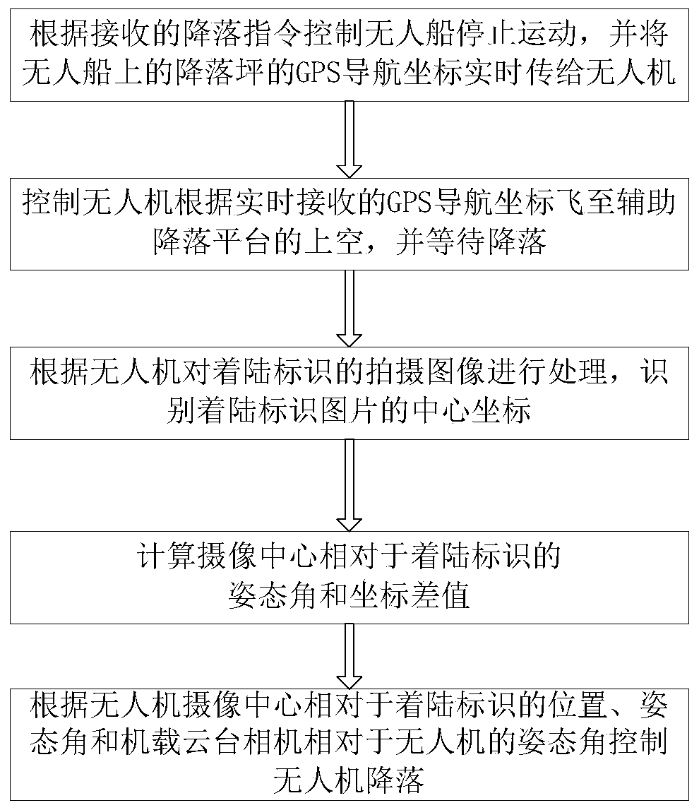
[0050] In order to make the object, technical solution and advantages of the present invention more clear, the present invention will be further described in detail below in conjunction with the examples. It should be understood that the specific embodiments described here are only used to explain the present invention, not to limit the present invention.

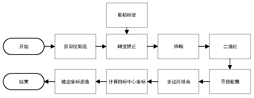
[0051] Such as figure 1 As shown, a UAV autonomous landing method based on GPS and image recognition hybrid navigation, the details are as follows:

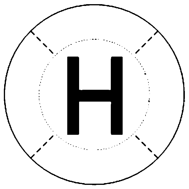
[0052] The present invention designs a specially designed ship-borne auxiliary landing platform, utilizes the existing airborne pan-tilt camera of the four-rotor UAV 1, and provides a vision-assisted rotor UAV with high precision, good reliability, and low cost. Landing method, especially suitable for landing on unmanned ships. The top view diagram including quadrotor UAV, airborne gimbal camera, airborne magnetic landing gear, ship-borne auxiliary landing platform, unmanned...


PUM


Abstract

The invention discloses an autonomous unmanned aerial vehicle landing method based on GPS and image recognition hybrid navigation and an autonomous unmanned aerial vehicle landing system based on theGPS and image recognition hybrid navigation. The autonomous unmanned aerial vehicle landing method comprises the following steps: 1), controlling an unmanned boat to stop motion according to a received landing instruction, and transmitting GPS navigation coordinates of a landing pad on the unmanned boat to an unmanned aerial vehicle in real time; 2), controlling the unmanned aerial vehicle to flyover an auxiliary landing platform, and waiting for the landing; 3), processing a shot image of a landing marker according to the unmanned aerial vehicle, and identifying the center coordinates of a landing marker picture; 4), according to the center coordinates of the shot picture, altitude data of the unmanned aerial vehicle and the coordinate position thereof, obtaining the position, the attitude angle and the coordinate difference of an image shooting center relative to the landing marker; and 5), according to the position and the attitude angle of the image shooting center of the unmannedaerial vehicle relative to the landing marker as well as the attitude angle of an airborne head camera relative to the unmanned aerial vehicle, controlling landing of the unmanned aerial vehicle. Theinvention provides the autonomous rotor-wing unmanned aerial vehicle landing method by which the precision is high, the reliability is high and the cost is low; the autonomous rotor-wing unmanned aerial vehicle landing method is especially applicable to landing of the unmanned aerial vehicle on the unmanned boat.

Description

technical field [0001] The invention relates to unmanned aerial vehicle technology, in particular to an unmanned aerial vehicle autonomous landing system based on GPS and image recognition hybrid navigation. Background technique [0002] With the extensive attention and development of small rotor UAVs and unmanned ships in the past two decades, they have appeared in everything from UAV aerial photography, surveying and mapping, plant protection to unmanned water quality monitoring and assisted rescue. Unmanned platforms can increase efficiency, reduce costs, and reduce unnecessary collateral damage. However, the field environment perception ability of a single UAV and unmanned ship is not enough to meet the needs of autonomous operations in the field, which limits its development and application in the field environment. Among them, the load and endurance of small UAVs are poor, and it is difficult to continue to perform tasks in the air. UAVs need to continuously replenish...

Claims


Application Information

Patent Timeline
IPC IPC(8): B64F1/00B64F1/18B64D47/08B64C39/02B64C25/32
Inventor 钟毅陆菲王文靖程书晓汪俊澎巴梦圆黄宇希刘益群
Owner WUHAN UNIV OF TECH
Why Eureka
Try Eureka