
BIM and 3D GIS fusion method for planning management

A fusion method and planning technology, applied in the direction of electronic digital data processing, geographic information database, special data processing applications, etc., can solve the problems of high labor costs, reduce labor and time costs, and solve the effects of loading and display efficiency

Active Publication Date: 2019-06-21
SHANGHAI MAPPING INST
View PDF5 Cites 9 Cited by
  • Summary
  • Abstract
  • Description
  • Claims
  • Application Information

AI Technical Summary

Problems solved by technology

As mentioned above, the technical solution of the present invention can realize the sharing and collaboration of data in the planning and design phase of construction projects, and can solve the problem that a large amount of labor costs are required to integrate BIM (Building Information Model) oriented to urban planning management into the current scene

Method used


Image

  • BIM and 3D GIS fusion method for planning management
  • BIM and 3D GIS fusion method for planning management
  • BIM and 3D GIS fusion method for planning management

Examples


Embodiment Construction

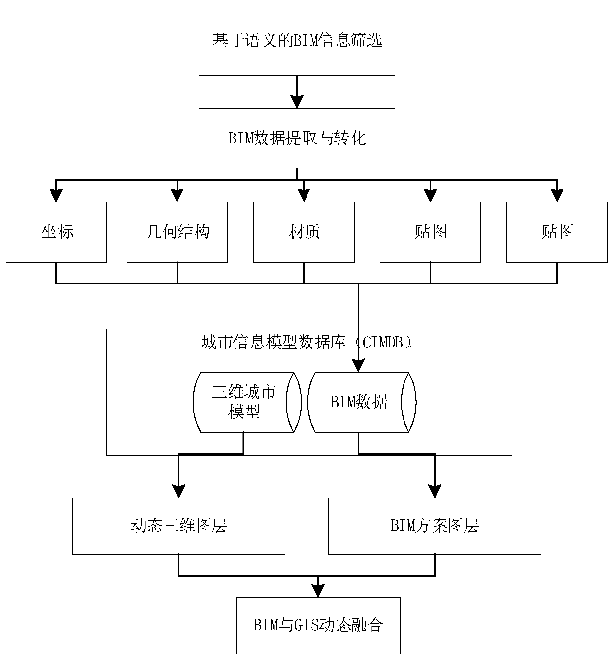
[0018] The technical solution of the present invention will be described in detail below in conjunction with the accompanying drawings.

[0019] 1. BIM information classification based on semantics, BIM information extraction based on semantic retrieval conditions:

[0020] BIM data classification is relatively professional, and it is difficult for non-BIM professional technicians to quickly and efficiently screen the information required for the project.

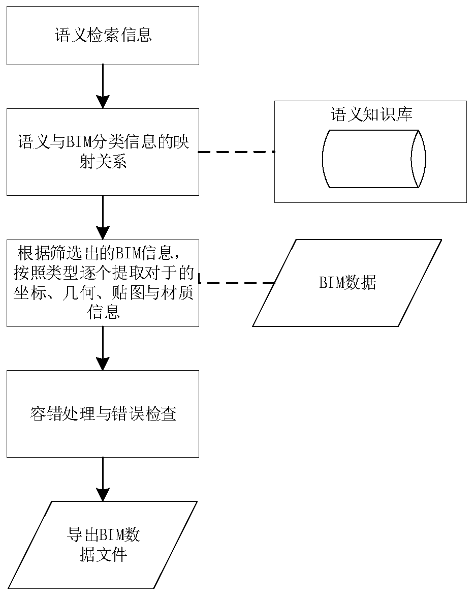
[0021] Semantics-based BIM information classification: Classify BIM building components according to attributes and functions, obtain semantics-based BIM family classification information and object information in the family, and use semantic identification to construct a semantic knowledge base.

[0022] The specific process is as figure 2 shown. Build a semantic knowledge base for BIM information screening. The semantic knowledge base stores the mapping relationship between various semantic information and BIM classifi...


PUM


Abstract

The method is applied to the field of urban planning management. The invention relates to a BIM and 3D GIS fusion method for planning management characterized by comprising the following steps of: firstly, constructing a semantic knowledge base so as to quickly extract BIM data of a construction engineering design scheme and implant the BIM data into current situation three-dimensional geographicinformation data under a semantic retrieval condition; adopting each building component monomer in the three-dimensional layer as an independent control object, calculating the implantation range of the current situation model of the corresponding area in the scheme by utilizing an existing space analysis algorithm according to the area block range where the BIM scheme is located, building the current situation model of the area by automatically hiding the scheme, and implanting BIM data into the current situation GIS data. The method is oriented to the service requirements of urban planning management, and is a set of efficient and complete BIM and GIS fusion technology method.

Description

technical field [0001] The method of the invention is applied to the field of urban planning management. Background technique [0002] BIM technology is a multi-dimensional (three-dimensional space, four-dimensional time, five-dimensional cost, N-dimensional more applications) model information integration technology, which can enable all parties involved in the construction project (including government departments, owners, design, construction, supervision, cost, operation management, project users, etc.) can operate information in the model and operate the model in the information during the entire life cycle of the project from concept generation to complete dismantling, thus fundamentally changing the way practitioners rely on drawings in the form of symbolic text. The working method of project construction and operation management achieves the goal of improving work efficiency, quality and reducing errors and risks throughout the life cycle of construction projects. ...

Claims


Application Information

Patent Timeline
IPC IPC(8): G06F16/58G06F16/587G06F16/538G06F16/36G06F16/29
Inventor 汪旻琦毛炜青郭功举潘冠杰张唯曹维潘琛
Owner SHANGHAI MAPPING INST
Learn More