
Cruising path planning system and method for unmanned surface vehicle in limited area

A cruising path and planning system technology, applied in radio wave measurement system, radio wave reflection/reradiation, utilization of reradiation, etc., can solve problems such as unreachable, inaccurate noise statistical characteristics, loss of track information, etc.

Pending Publication Date: 2019-06-28
江苏航运职业技术学院
View PDF4 Cites 10 Cited by
  • Summary
  • Abstract
  • Description
  • Claims
  • Application Information

AI Technical Summary

Problems solved by technology

[0006] Aiming at the deficiencies of the prior art, the present invention provides a limited-area surface unmanned boat cruising path planning system and method, which solves the problem of existing track associations when the traffic environment is relatively complex and there are many track point data to be processed. , it is prone to excessive "de-repetition" phenomenon, and the real track information is lost. At the same time, when obtaining obstacle information and unmanned ship information for radar or AIS, it will bring Inaccurate models, inaccurate noise statistical characteristics, or non-stationary objects, the existing unmanned vehicle track planning system cannot achieve approximation to any nonlinear mapping, and cannot achieve the nonlinear and time-varying mathematical model for the initial alignment of the strapdown system. and uncertainty characteristics, to carry out precise determination of the model for each data purpose problem

Method used


Image

  • Cruising path planning system and method for unmanned surface vehicle in limited area
  • Cruising path planning system and method for unmanned surface vehicle in limited area
  • Cruising path planning system and method for unmanned surface vehicle in limited area

Examples


Embodiment Construction

[0027]The following will clearly and completely describe the technical solutions in the embodiments of the present invention with reference to the accompanying drawings in the embodiments of the present invention. Obviously, the described embodiments are only some, not all, embodiments of the present invention. Based on the embodiments of the present invention, all other embodiments obtained by persons of ordinary skill in the art without making creative efforts belong to the protection scope of the present invention.

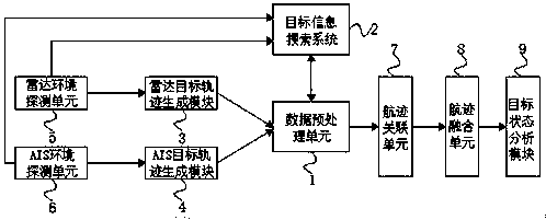
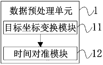
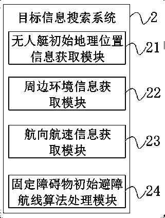
[0028] see Figure 1-4 , the embodiment of the present invention provides a technical solution: a limited-area surface unmanned boat cruising path planning system, including a data preprocessing unit 1 and a target information search system 2, and the data preprocessing unit 1 and the target information search system 2 realize Two-way connection, the input end of data preprocessing unit 1 is connected with the output end of radar target trajectory generation mo...


PUM


Abstract

The invention discloses a cruising path planning system and method for an unmanned surface vehicle in a limited area, the cruising path planning system comprises a data preprocessing unit and a targetinformation searching system, the data preprocessing unit and the target information searching system are connected in two ways, and an input end of the data preprocessing unit is connected with output ends of a radar target track generating module and an AIS (Automatic Identification System) target track generating module. The invention relates to the technical field of maritime control. According to the cruising path planning system and method for the unmanned surface vehicle in the limited area, the optimal association effect is achieved through a dynamically regulated value of a track association part, the data association accuracy is improved on a certain degree, meanwhile, the filter techniqueis used to reduce the influence brought about by the indeterminacy of a model when a radaror an AIS acquires information of an obstacle and an unmanned surface vehicle, the robustness of a filtering algorithm is improved, the estimation speed is increased, and the neural network techniqueis used to approach the model in reality to the greatest extent.

Description

technical field [0001] The invention relates to the technical field of maritime supervision, in particular to a system and method for planning a cruising path of an unmanned surface boat in a limited area. Background technique [0002] The current maritime supervision mode is changing from in-event and post-event supervision to the whole-process supervision mode in advance, during and after the event, and the means of supervision have changed from the traditional "ship cruise and VTS monitoring" to "ship cruise, VTS, electronic cruise" Combined with the transformation of comprehensive cruise means, my country is currently committed to creating a smart maritime province with "on-site mapping, monitoring into the network, data into the chain, strong support, and convenient service", adapting to the new normal of economic development, relying on scientific and technological information technology, and establishing a wide coverage , Deeply interconnected information network, provi...

Claims


Application Information

Patent Timeline
Patent Type & Authority Applications(China)
IPC IPC(8): G01S13/93G01S13/58
Inventor 陈婷婷
Owner 江苏航运职业技术学院
Learn More