A sea antenna positioning method based on pose information measurement

A positioning method and sea antenna technology, which are applied in the directions of measuring devices, measuring angles, surveying and navigation, etc., can solve the problems of observing sea antennas, large errors and low reliability of sea antenna positioning results.

Active Publication Date: 2020-05-15
SHENYANG INST OF AUTOMATION - CHINESE ACAD OF SCI
View PDF3 Cites 0 Cited by
  • Summary
  • Abstract
  • Description
  • Claims
  • Application Information

AI Technical Summary

Problems solved by technology

The problem with this type of method is that the images often contain various scenes such as clouds, ships, seawater layers, fish scales, etc. In some extreme cases, the sea antenna cannot even be observed in the image, resulting in large errors in the sea antenna positioning results, and the credibility Low

Method used

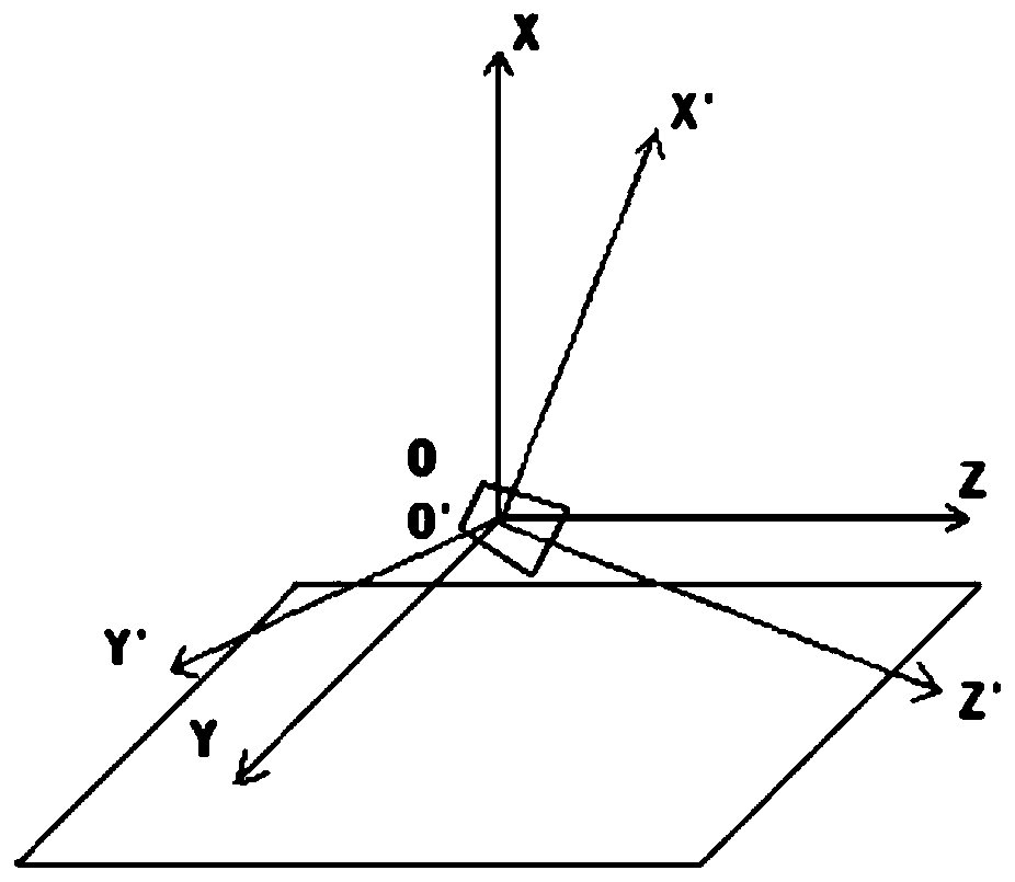

Image

  • A sea antenna positioning method based on pose information measurement
  • A sea antenna positioning method based on pose information measurement
  • A sea antenna positioning method based on pose information measurement

Examples


Embodiment 1

[0076] Example 1. Sea antenna positioning results

[0077] In order to illustrate the effectiveness of the method of the present invention, a field test was carried out using the method. The field of view of the camera used was 6.1°×4.88°, the output image of the camera was 320×256, and the imaging altitude was 10m and 2800m.

[0078] Such as Figure 5 Shown is a schematic diagram of the sea antenna detection results of the present invention. Among them, (c) is the detection result without correction for the atmospheric refraction effect, and (a), (b), and (d) are the detection results with correction.

[0079] The white line segment is the positioning sea line. (a) and (b) are 10m above sea level, (c) and (d) are 2800m, the result in (c) does not correct the atmospheric refraction error, and there is a certain error between the positioning result and the real position, and the result in (d) is correct The atmospheric refraction error has been corrected, and the positioning...


PUM


Abstract

The invention relates to a sea-sky-line positioning method based on pose information measurement. The attitude and the altitude of a camera are solved by using measurement information of a GPS / INS integrated navigation system and a biaxial pan / tilt, the position of the sea-sky-line in a sea surface image is further calculated, and by using an Rueger formula, sea-sky-line positioning errors causedby atmospheric refraction effects are corrected. The method is high in positioning precision, does not involve an image processing process and has an anti-interference ability for meteorological and hydrological condition changes.

Description

technical field [0001] The invention relates to the technical field of sea background image calibration, in particular to a sea antenna positioning method based on pose information measurement. Background technique [0002] In applications such as marine monitoring and marine resource research, it is often necessary to use cameras mounted on aircraft to take pictures of the sea surface in the air, and the images obtained often include the sea surface and the sky. If the boundary position between the sea surface and the sky (that is, the sea antenna) can be quickly and accurately located, it will be helpful for subsequent analysis and processing of the sea surface image. [0003] The existing sea-antenna positioning methods are based on various image processing techniques to calculate and locate the sea-antenna in the acquired sea surface images. The problem with this type of method is that the images often contain various scenes such as clouds, ships, seawater layers, fish ...

Claims


Application Information

Patent Timeline
Patent Type & Authority Patents(China)
IPC IPC(8): G01C11/04G01C1/00
CPCG01C1/00G01C11/04
Inventor 史泽林刘云鹏向伟王喆鑫孙健田政
Owner SHENYANG INST OF AUTOMATION - CHINESE ACAD OF SCI
Why Eureka
Try Eureka