

Remote sensing image object level change detection method
A remote sensing image and change detection technology, applied in the field of image processing, can solve the problems that the data has not been analyzed and utilized, and the analysis and processing ability of remote sensing data in complex environments has not been correspondingly improved, so as to achieve the effect of improving precision and accuracy
- Summary
- Abstract
- Description
- Claims
- Application Information
AI Technical Summary
Problems solved by technology
Method used
Image

Examples
Embodiment Construction
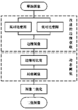
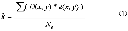
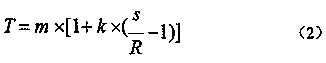
[0023] In the embodiment of the present invention, a method for detecting changes in the object level of remote sensing images specifically includes image preliminary processing, mean filtering acquisition calculation, and image analysis;
[0024] S1. Preliminary image processing. Input the initial image into a pre-trained deep fully convolutional neural network model to obtain the probability that each pixel in the initial image output by the deep fully convolutional neural network model is a character pixel, where The deep fully convolutional neural network model is obtained by pre-training training images with real regions marked with characters; then the pixels in the initial image are classified, wherein pixels with a probability greater than a preset probability threshold are classified The class is character pixels; multiple training layers are obtained through multiple image processing, and the training layers are superimposed to obtain preliminary graphics;
[0025] S2. Pe...
PUM
 Abstract
Description
Claims
Application Information