Remote sensing image classification algorithm based on mRMR selection and improved FCM clustering

A remote sensing image and classification algorithm technology, applied in computing, computer components, character and pattern recognition, etc., can solve the problems of high correlation, poor classification accuracy, high redundancy, etc., and achieve the effect of accurate classification

Inactive Publication Date: 2019-07-09
CHONGQING UNIV OF POSTS & TELECOMM
View PDF6 Cites 2 Cited by
  • Summary
  • Abstract
  • Description
  • Claims
  • Application Information

AI Technical Summary

Problems solved by technology

[0005] Aiming at the problem of poor classification accuracy caused by high correlation between high-resolution image features, high redundancy, and poor robustness of FCM clustering, this invention proposes a remote sensing image classification method based on mRMR selection and improved FCM clustering

Method used


Image

  • Remote sensing image classification algorithm based on mRMR selection and improved FCM clustering
  • Remote sensing image classification algorithm based on mRMR selection and improved FCM clustering
  • Remote sensing image classification algorithm based on mRMR selection and improved FCM clustering

Examples


Embodiment Construction

[0057] The present invention will be further described in detail below in conjunction with examples and specific implementation methods. However, it should not be understood that the scope of the above subject matter of the present invention is limited to the following embodiments, and all technologies realized based on the content of the present invention belong to the scope of the present invention.

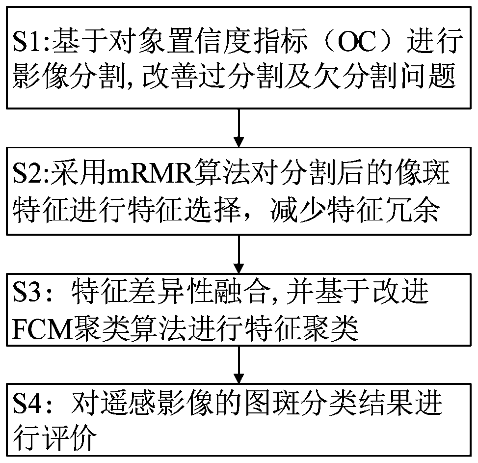
[0058] figure 1 The remote sensing image classification method based on mRMR selection and improved FCM clustering of an exemplary embodiment of the present invention specifically includes the following steps:

[0059] S1: Construct an object-oriented multi-scale segmentation algorithm to segment images.

[0060] In this embodiment, an object-oriented multi-scale segmentation algorithm is used to measure the matching degree between any region and a geographic object by constructing a new object confidence (OC) index to segment the image, generate image spots, and improve the i...


PUM


Abstract

The invention discloses a remote sensing image classification algorithm based on mRMR selection and improved FCM clustering. The method comprises the following steps: S1, constructing a new object confidence coefficient (OC) index to measure an object-oriented multi-scale segmentation algorithm of a matching degree between any region and a geographic object, segmenting an image to generate image spots, and improving over-segmentation and under-segmentation problems in an image segmentation process; S2, introducing an mRMR feature selection algorithm, utilizing mutual information to measure thecorrelation and redundancy of different features, and searching a feature subset according to the information difference and the information entropy, so that the minimum redundancy exists between theselected feature and the target category, and the feature redundancy problem is solved; S3, performing feature distance calculation by adopting an improved FCM classification algorithm of significantfeature difference fusion to realize image classification; and S4, evaluating a pattern spot classification result of the remote sensing image. The images are classified, so that accurate classification of ground object categories is realized. According to the invention, the overall precision of classification reaches 94%.

Description

technical field [0001] The invention relates to the field of remote sensing image classification, in particular to a remote sensing image classification method based on mRMR selection and improved FCM clustering. Background technique [0002] With the development of remote sensing imaging technology, the spatial resolution of high-resolution remote sensing images has increased year by year, and has become one of the main data sources for obtaining ground object information. High-resolution images have the characteristics of rich texture information, obvious shape features, and widespread spectral aliasing. The classification method that only uses spectral features is difficult to meet the classification requirements. The mainstream trend of high-resolution image classification. However, due to the high dimensionality of image features, it is easy to cause redundancy and increase the difficulty of classification. [0003] Dimensionality reduction is an important research co...

Claims


Application Information

Patent Timeline
Patent Type & Authority Applications(China)
IPC IPC(8): G06K9/62
CPCG06F18/2113G06F18/23G06F18/22G06F18/24
Inventor 向泽君黄磊王汝言
Owner CHONGQING UNIV OF POSTS & TELECOMM
Why Eureka
Try Eureka