Method for determining GPS deception by single unmanned aerial vehicle based on Kalman filtering under wind field interference

A Kalman filter and UAV technology, applied in the field of sensor information, can solve the problems of anti-GPS spoofing, low reliability, cumbersome wind field estimation, etc.

Active Publication Date: 2019-07-12
XIDIAN UNIV
View PDF4 Cites 3 Cited by
  • Summary
  • Abstract
  • Description
  • Claims
  • Application Information

AI Technical Summary

Problems solved by technology

This makes wind field inference cumbersome
In addition, from the perspective of anti-GPS spoofing, the above method of judging GPS spoofing does not take into account the situation of the wind field, and the judgment result obtai

Method used


Image

  • Method for determining GPS deception by single unmanned aerial vehicle based on Kalman filtering under wind field interference
  • Method for determining GPS deception by single unmanned aerial vehicle based on Kalman filtering under wind field interference
  • Method for determining GPS deception by single unmanned aerial vehicle based on Kalman filtering under wind field interference

Examples


Embodiment Construction

[0066] The present invention is described in further detail below in conjunction with accompanying drawing:

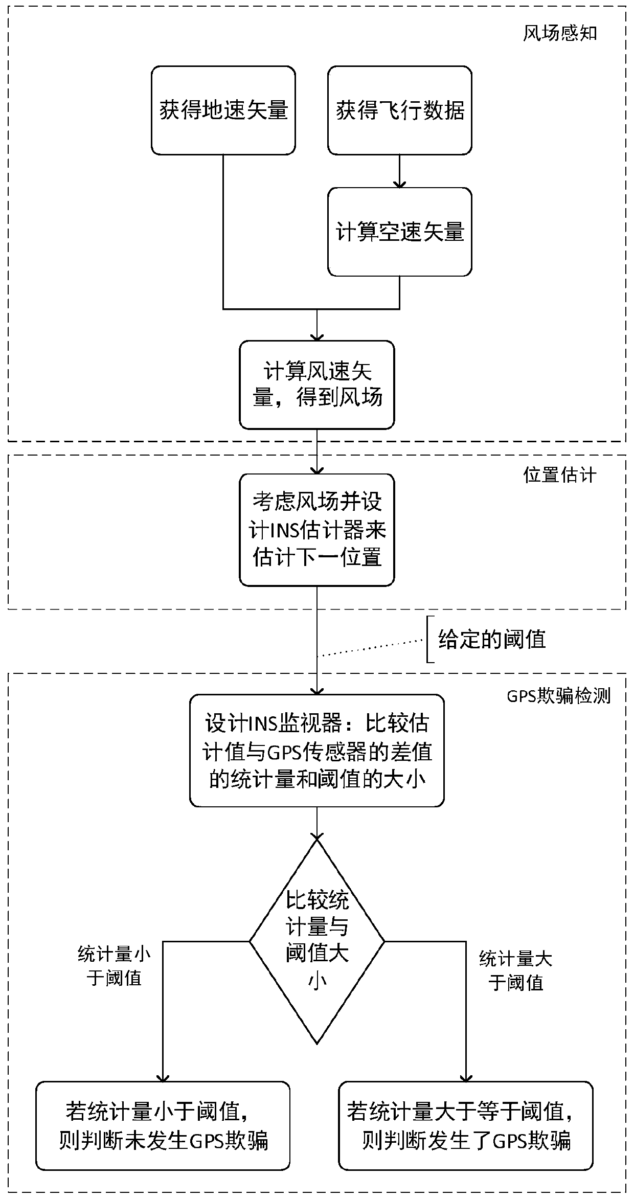
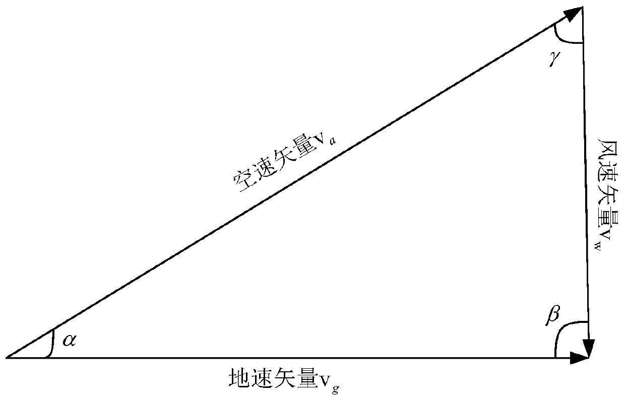
[0067] The invention discloses a method for judging GPS spoofing by a single UAV based on Kalman filtering under wind field interference; it includes three steps of wind field perception, position estimation, and GPS spoofing detection, and its calculation idea is: through the real-time data of the sensor Wind conditions can be obtained. The wind field conditions will affect the position estimation based on the inertial navigation module. After the wind field conditions are known, the influence of the wind on the position estimation can be eliminated, so that the reliability of the final judgment result about whether GPS spoofing occurs is more reliable. high. see figure 1 , the specific process of the present invention is: in the wind field sensing stage, the UAV obtains the ground speed vector, the air speed vector and the wind vector of the UAV according to the GP...


PUM


Abstract

The invention discloses a method for determining GPS deception by a single unmanned aerial vehicle based on Kalman filtering under wind field interference. The method comprises the steps of: wind field perception, position estimation and GPS deception detection. The calculation idea is as follows: the wind field condition can be obtained according to the real-time data of the sensor, the wind field condition can influence the position speculating based on an inertial navigation module, and after the wind field condition is known, the influence of wind on the position speculating can be eliminated, so that the reliability of the finally obtained determination result about whether GPS cheating occurs or not is higher.

Description

[0001] 【Technical field】 [0002] The invention belongs to the field of sensor information, and in particular relates to a method for judging GPS spoofing by a single drone based on Kalman filtering under wind field interference. [0003] 【Background technique】 [0004] Due to the rapid development of drones in recent years, the safety of unmanned aerial vehicles (UAVs) has become very important. The Global Positioning System (GPS) is the second-generation satellite navigation system in the United States. As the main navigation module of UAVs, it has been able to realize navigation and positioning in various fields such as ocean, land, and air, especially on the ground. For military drones, the high-precision positioning of GPS can help them complete precise guidance and strikes in the military sense. High-precision GPS will reflect its great value in war. Moreover, GPS is also of great significance to civilian drones. At present, more and more drones are landing in civilian ...

Claims


Application Information

Patent Timeline
IPC IPC(8): G01S19/21
CPCG01S19/21Y02A90/10
Inventor 马建峰赵昊罡魏大卫习宁卢笛贺蕾
Owner XIDIAN UNIV
Why Eureka
Try Eureka