Road edge identification method and device based on laser point cloud

A laser point cloud and recognition method technology, applied in the field of geographic information, can solve the problems of many obstacle points along the road, low accuracy along the road, poor applicability, etc., to reduce the introduction of obstacle points, reduce noise points, Obstacle points introduce less effect

Inactive Publication Date: 2019-07-19
SHENYANG MXNAVI CO LTD
View PDF6 Cites 5 Cited by
  • Summary
  • Abstract
  • Description
  • Claims
  • Application Information

AI Technical Summary

Problems solved by technology

[0006] As mentioned above, the scope of application of the calculation of roadside points in the prior art is limited by certain factors, and the applicability is poor.
And the calculation is relatively complicated, the amount of calculation is large, and there are many obstacle points along the road obtained, which leads to the low accuracy of the final road along the road

Method used


Image

  • Road edge identification method and device based on laser point cloud
  • Road edge identification method and device based on laser point cloud
  • Road edge identification method and device based on laser point cloud

Examples


Embodiment

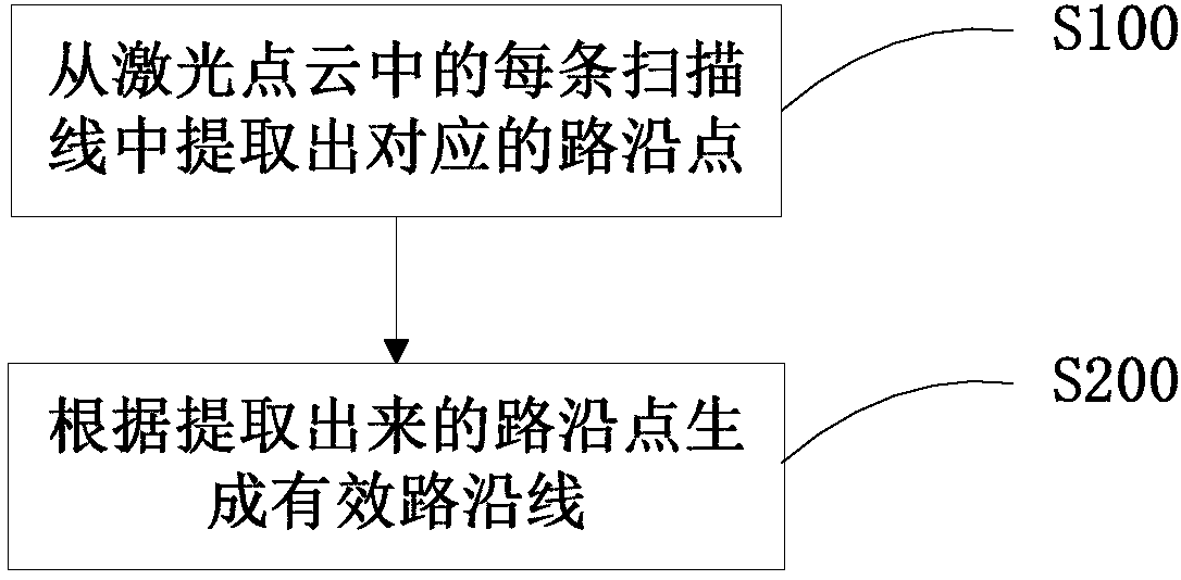
[0085] An embodiment of the present invention provides a roadside recognition method based on laser point cloud, the process of which is as follows figure 1 shown, including the following steps:

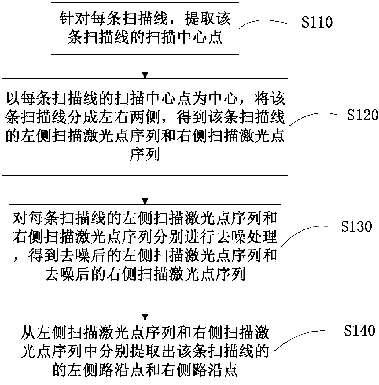
[0086] Step S100: Extract corresponding roadside points from each scanning line in the laser point cloud.

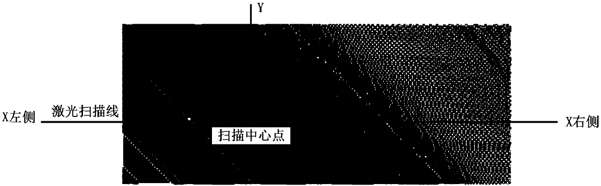
[0087] Such as figure 2 As shown in Fig. 1, the laser point cloud is composed of a large number of laser scanning points, which are organized according to one laser scanning line when stored. Taking a single scan line as the calculation unit, the corresponding roadside points are extracted from each scan line included in the laser point cloud.

[0088] Step S200: Generate an effective roadside line according to the extracted roadside points.

[0089] The extraction of roadside points in this embodiment uses a single scanning line as the calculation unit, which has low computational complexity and a small amount of calculation, and can be applied to large-scale high-precisio...


PUM


Abstract

The invention discloses a road edge identification method and device based on laser point cloud. The method comprises the following steps: extracting a corresponding road edge point from each scanningline in a laser point cloud; and generating an effective road edge line according to the extracted road edge points. The road edge line can be accurately identified, and the method is suitable for road edge manufactured with any building material, road edge of any shape, horizontal roads, inclined roads and the like; and the calculation amount is small, and the method is suitable for large-scalehigh-precision data acquisition operation.

Description

technical field [0001] The invention relates to the technical field of geographic information, in particular to a roadside recognition method and device based on laser point clouds. Background technique [0002] With the continuous development of information technology, electronic maps and electronic navigation are gradually popularized in people's daily life, and providing users with more accurate road information has become an important focus of various service providers. [0003] At present, the ranging accuracy of lidar has reached the centimeter level, and the captured point cloud has the advantages of large data volume and rich feedback information, so it is widely used in high-precision map data collection operations. The roadside recognition based on the laser point cloud is the first step of high-precision data processing. The key point of the roadside recognition based on the laser point cloud is how to extract the roadside points from the point cloud. At present,...

Claims


Application Information

Patent Timeline
Patent Type & Authority Applications(China)
IPC IPC(8): G06T7/521
CPCG06T2207/10028G06T2207/20182G06T7/521
Inventor 范晨星林得得
Owner SHENYANG MXNAVI CO LTD
Why Eureka
Try Eureka