Small hydraulic engineering water surface area and water storage capacity derivation method based on remote sensing

A technology for water surface area and water conservancy engineering, which is applied to measurement devices, re-radiation, and re-radiation of sound waves. degree of effect

Pending Publication Date: 2019-07-30
广东华宫水利水电建设工程有限公司
View PDF5 Cites 1 Cited by
  • Summary
  • Abstract
  • Description
  • Claims
  • Application Information

AI Technical Summary

Problems solved by technology

②Water conservancy projects are generally large in scale, require large investment, complex technology and long construction period
[0004] Water conservancy projects often involve estimating the water area and water storage capacity in water conservancy projects. The current estimation method is inconvenient and has low accuracy, especially for small water conservancy projects. Therefore, we have introduced a method based on Calculation Method of Water Surface Area and Storage Capacity of Small Water Conservancy Projects Based on Remote Sensing

Method used


Image

  • Small hydraulic engineering water surface area and water storage capacity derivation method based on remote sensing
  • Small hydraulic engineering water surface area and water storage capacity derivation method based on remote sensing
  • Small hydraulic engineering water surface area and water storage capacity derivation method based on remote sensing

Examples


Embodiment 1

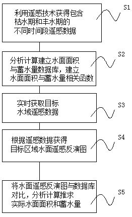
[0031] Example 1: Please refer to figure 1 A remote sensing-based method for calculating the water surface area and water storage capacity of a small water conservancy project includes the following steps: S1. Acquiring remote sensing data of target waters in different time periods; remote sensing data of target waters in different time periods including dry seasons and wet seasons.

[0032] S2. Analyze and calculate to establish the database of water surface area and water storage capacity in the target area, and establish the correlation function relationship between water surface shape, area and water storage capacity;

[0033] S3. Obtain remote sensing data of the target water area in real time;

[0034] S4. Obtain the remote sensing inversion map of the water surface in the target area according to the remote sensing data;

[0035] S5. Comparing the water surface remote sensing inversion map with the database, analyzing and calculating the actual water surface area and w...

Embodiment 2

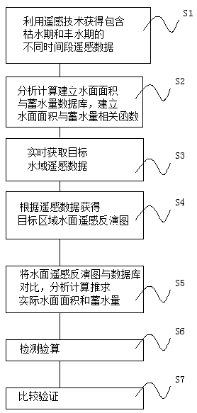
[0043] Example 2: Please refer to figure 2 A remote sensing-based method for calculating the water surface area and water storage capacity of a small water conservancy project includes the following steps: S1. Acquiring remote sensing data of target waters in different time periods; remote sensing data of target waters in different time periods including dry seasons and wet seasons.

[0044] S2. Analyze and calculate to establish the database of water surface area and water storage capacity in the target area, and establish the correlation function relationship between water surface shape, area and water storage capacity;

[0045] S3. Obtain remote sensing data of the target water area in real time;

[0046] S4. Obtain the remote sensing inversion map of the water surface in the target area according to the remote sensing data;

[0047] S5. Comparing the water surface remote sensing inversion map with the database, analyzing and calculating the actual water surface area and ...

Embodiment 3

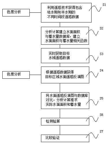
[0057] Example 3: Please refer to image 3 A remote sensing-based method for calculating the water surface area and water storage capacity of a small water conservancy project includes the following steps: S1. Acquiring remote sensing data of target waters in different time periods; remote sensing data of target waters in different time periods including dry seasons and wet seasons.

[0058] S2. Analyze and calculate to establish the database of water surface area and water storage capacity in the target area, and establish the correlation function relationship between water surface shape, area and water storage capacity;

[0059] S3. Obtain remote sensing data of the target water area in real time;

[0060] S4. Obtain the remote sensing inversion map of the water surface in the target area according to the remote sensing data;

[0061] S5. Comparing the water surface remote sensing inversion map with the database, analyzing and calculating the actual water surface area and w...


PUM


Abstract

The invention discloses a small hydraulic engineering water surface area and water storage capacity derivation method based on remote sensing. The method comprises the following steps that: S1: obtaining the target water domain remote sensing data of different time periods, wherein the target water domain remote sensing data includes the target water domain remote sensing data of different time periods in drought periods and wet seasons; S2: analyzing, calculating and establishing the water surface area and water storage capacity database of a target region, and establishing a relevant function relationship among the shape of the water surface, the water surface area and the water storage capacity; S3: obtaining the remote sensing data of the target water domain in real time; and S4: according to the remote sensing data, obtaining the remote sensing inversion chart of the water surface of the target region. The invention provides the small hydraulic engineering water surface area and water storage capacity derivation method based on the remote sensing. By use of the method, firstly, the water surface area and water storage capacity database of the target region is established, thewater surface area and water storage capacity database of the target region can be taken as a basis to bring convenience for subsequent monitoring, according to requirements, real-time target water domain remote sensing data is subjected to derivation in real time to obtain the area and the water storage capacity of the target water domain, and the method is convenient, quick and high in accuracy.

Description

technical field [0001] The invention belongs to the technical field of water conservancy engineering, and specifically relates to a method for calculating the water surface area and water storage capacity of a small-scale water conservancy project based on remote sensing. Background technique [0002] Water conservancy project is a general term for various engineering constructions built to control, utilize and protect surface and underground water resources and the environment; [0003] Projects built to eliminate water damage and develop and utilize water resources. According to its service objects, it is divided into flood control projects, farmland water conservancy projects, hydropower projects, waterway and port projects, water supply and drainage projects, environmental water conservancy projects, and tidal flat reclamation projects. Water conservancy projects that can simultaneously serve multiple purposes such as flood control, water supply, irrigation, and power g...

Claims


Application Information

Patent Timeline
IPC IPC(8): G01S15/88
CPCG01S15/88
Inventor 陈正焕陈证煌陈星孔
Owner 广东华宫水利水电建设工程有限公司
Why Eureka
Try Eureka