InSAR-based monitoring method for airport deformation in reclamation areas

A deformation and regional technology, applied in measurement devices, radio wave measurement systems, radio wave reflection/re-radiation, etc. and density, the effect of improving accuracy

Active Publication Date: 2019-08-09
CHENGDU UNIVERSITY OF TECHNOLOGY
View PDF5 Cites 9 Cited by
  • Summary
  • Abstract
  • Description
  • Claims
  • Application Information

AI Technical Summary

Problems solved by technology

However, the X-band radar has a short wavelength and is easily affected by decoherence. At the same time, the geological conditions of land reclamation areas are usually complex, and complex geological conditions will cause the deformation pattern of the buildings on it to change, resul

Method used


Image

  • InSAR-based monitoring method for airport deformation in reclamation areas
  • InSAR-based monitoring method for airport deformation in reclamation areas
  • InSAR-based monitoring method for airport deformation in reclamation areas

Examples


Embodiment

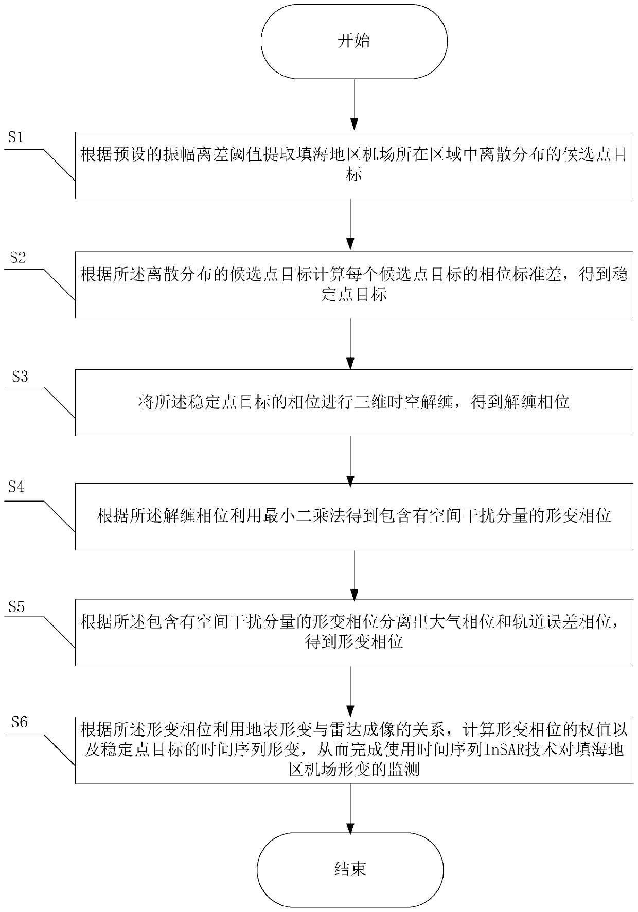
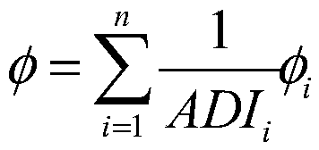
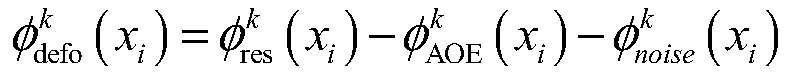
[0044] The present invention utilizes time series InSAR technology to monitor airports in land reclamation areas, improves the method of combining ADI and time coherence coefficients to identify point targets in low coherence areas, and eliminates possible erroneous point targets by setting the phase standard deviation threshold of candidate points , which is to calculate the phase standard deviation of each candidate point. If the minimum phase standard deviation of the point in any interference pair is greater than the threshold, the point will be discarded as an unstable point target. The specific implementation of the method is as follows:

[0045] Such as figure 1 As shown, the present invention discloses a method for monitoring deformation of airports in reclamation areas based on InSAR, and its implementation method is as follows:

[0046] S1. Extract the discretely distributed candidate point targets in the area where the airport in the reclamation area is located acco...


PUM


Abstract

The invention provides an InSAR-based monitoring method for airport deformation in reclamation areas. The InSAR-based monitoring method for airport deformation in the reclamation areas comprises the steps that candidate point targets distributed discretely are extracted; the phase standard deviation of each candidate point target is calculated to obtain a stable point target; three-dimensional space-time unwrapping is carried out on a phase of the stable point target to obtain an unwrapped phase; a least square method is used, and a deformation phase containing spatial interference componentsis obtained; an atmospheric phase and an orbit error phase are separated out according to the deformation phase containing the spatial interference components to obtain the deformation phase; and theweight of the deformation phase and the time series deformation of the stable point target are calculated, so that the monitoring of the airport deformation in the reclamation areas is completed by using the time series InSAR technology. According to the InSAR-based monitoring method for airport deformation in the reclamation areas, an amplitude deviation threshold value and a time coherence coefficient method are combined, so that the number and density of the candidate point targets in the reclamation airport areas are improved, and the deformation rate accuracy is improved; and the InSAR-based airport deformation monitoring method of the reclamation areas can further be used for high-precision inversion of deformation fields in complex field areas in low coherence areas.

Description

technical field [0001] The invention belongs to the technical field of surface deformation monitoring, in particular to an InSAR-based method for monitoring airport deformation in reclamation areas. Background technique [0002] Conventional surface deformation monitoring methods mainly include traditional geodetic surveying, such as setting layer markers, leveling surveys, and GPS surveys. The above monitoring methods can only obtain deformation data at a small number of discrete observation points, and cannot be used to reveal the spatiotemporal evolution of the surface deformation field. Compared with the traditional surface monitoring methods, the time series InSAR technology can monitor deformation in a large range, and the accuracy can be achieved. up to millimeters. By collecting SAR image sets covering the same area, this technology focuses on ground point targets that maintain high coherence in long-term sequence SAR images. It has been successfully applied to urba...

Claims


Application Information

Patent Timeline
IPC IPC(8): G01S13/90G01B21/32
CPCG01B21/32
Inventor 蒋亚楠廖露王鹏蒋川东卢熊姜玮旭罗袆沅
Owner CHENGDU UNIVERSITY OF TECHNOLOGY
Why Eureka
Try Eureka