Eureka AIR delivers breakthrough ideas for toughest innovation challenges, trusted by R&D personnel around the world.

Generating system and method for high-precision three-dimensional navigation map of fully mechanized mining face

The technology of fully mechanized mining face and navigation map is applied in the field of high-precision three-dimensional navigation map generation system of fully mechanized mining face, which can solve the problems of large fluctuation and change of coal seam, inability to realize unmanned mining, etc., and achieves convenient operation and high speed. , get the effect of a simple method

Active Publication Date: 2019-08-13
CHINA UNIV OF MINING & TECH
View PDF4 Cites 9 Cited by
  • Summary
  • Abstract
  • Description
  • Claims
  • Application Information

AI Technical Summary

Problems solved by technology

At present, in working faces with relatively simple geological conditions and coal seam structures, unmanned mining can be realized by combining memory cutting and manual remote intervention, but most of the working faces in my country have very complicated geological conditions and coal seam structures (such as coal seam Large ups and downs, there are dangerous geological structures such as faults and folds), which makes it impossible to realize unmanned mining with existing technologies

Method used


Image

  • Generating system and method for high-precision three-dimensional navigation map of fully mechanized mining face
  • Generating system and method for high-precision three-dimensional navigation map of fully mechanized mining face
  • Generating system and method for high-precision three-dimensional navigation map of fully mechanized mining face

Examples


Embodiment Construction

[0039] The present invention will be further described below in conjunction with the embodiment in the accompanying drawings:

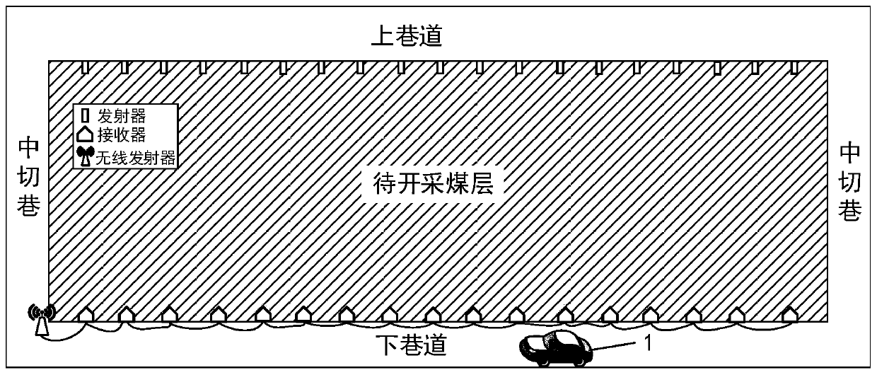
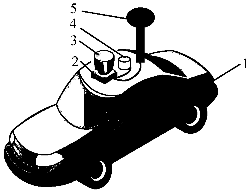
[0040] Such as figure 1 As shown, the generation system of the high-precision three-dimensional navigation map of the fully mechanized mining face of the present invention includes a vehicle-mounted mobile measurement platform 1 and channel wave seismometers arranged on both sides of the coal seam to be mined. The channel wave seismometers include intervals arranged in the upper roadway The transmitter and the receiver arranged in the lower roadway at intervals, the receivers are connected by a network cable and connected with a wireless transmitter; the transmitter is a channel wave seismic signal transmitter, and the receiver is a channel wave seismic signal receiver. The wave seismic signal receiver transmits the data to the data receiving processor 2 through the wireless transmitter, and the channel wave seismic signal transmitter and the channel ...


PUM


Abstract

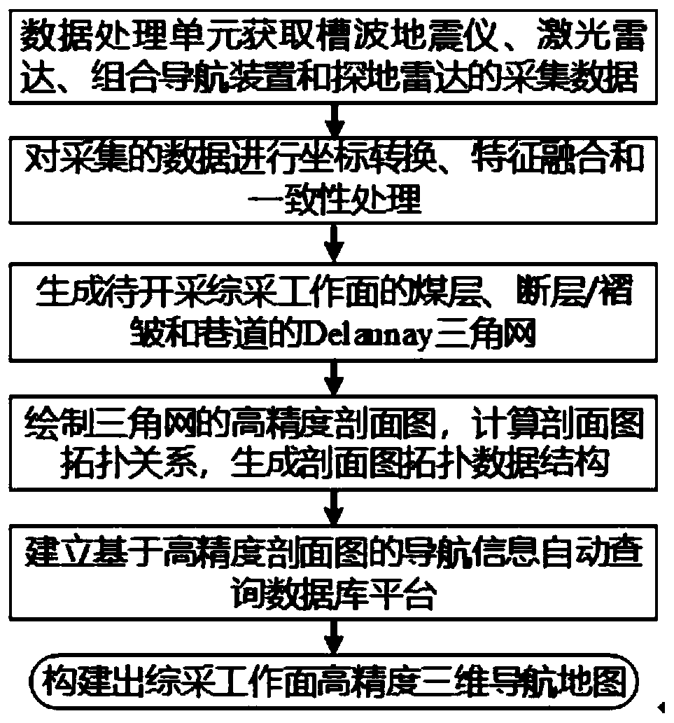
The invention discloses a generating system and a method for generating a high-precision three-dimensional navigation map of a fully mechanized mining face, and is adapted for use in the technical field of unmanned mining. The generating system comprises a channel wave seismometer, a laser radar, a combined navigation device, a ground penetrating radar and a data processing unit. The data processing unit acquires data collected by various sensors and then conducts coordinate conversion, feature fusion and consistency processing for the acquired data to generate a Delaunay triangle network of acoal seam, a fault / fold and a roadway; draws a high-precision profile map of the triangle map, calculates a topological relationship of the profile map, generates a topological data structure of theprofile map, establishes a navigation information automatic query database platform based on the high-precision profile map, and constructs the high-precision three-dimensional navigation map of the fully mechanized mining face. The high-precision three-dimensional navigation map generated by the invention can provide accurate the thickness information of the coal seam, the varied dip angle of thecoal seam and the position of the dangerous geological structure space for the fully mechanized mining equipment, and has functions of high-precision positioning, information sensing and path planning.

Description

technical field [0001] The invention relates to a generation system and method, and is especially suitable for a generation system and method of a high-precision three-dimensional navigation map of a fully mechanized mining face used in the technical field of unmanned mining. Background technique [0002] Unmanned mining of coal mines is a cutting-edge technology commonly pursued by the international coal mining field. It is an important means to reduce casualties and ensure safe production, and it is also an effective way for my country's coal mines to achieve safe, efficient and green mining. At present, in working faces with relatively simple geological conditions and coal seam structures, unmanned mining can be realized by combining memory cutting and manual remote intervention, but most of the working faces in my country have very complex geological conditions and coal seam structures (such as coal seam There are large undulations, and there are dangerous geological stru...

Claims


Application Information

Patent Timeline
Patent Type & Authority Applications(China)
IPC IPC(8): G01C21/00G01C21/16G01S17/08G01V1/30G06T17/05G06T17/20
CPCG01C21/005G01C21/165G01V1/30G01S17/08G06T17/05G06T17/20G01S13/865G01S17/86G01S17/87G01S17/89G01S13/931G01S13/885G01C21/1652G01C21/3826E21C41/00E21C35/24E21C39/00G01S7/4808
Inventor 刘万里葛世荣王世博伊世学
Owner CHINA UNIV OF MINING & TECH
Why Eureka
Eureka Blog
Learn More