Lane line updating method, device, equipment and system and readable storage medium

An update method and technology of lane lines, applied in the field of high-precision maps, can solve problems such as incorrect update of lane lines

Active Publication Date: 2019-08-20
BEIJING BAIDU NETCOM SCI & TECH CO LTD
View PDF6 Cites 15 Cited by
  • Summary
  • Abstract
  • Description
  • Claims
  • Application Information

AI Technical Summary

Problems solved by technology

If the obtained lateral offset exceeds a certain threshold, it may cause incorrect update of lane lines

Method used


Image

  • Lane line updating method, device, equipment and system and readable storage medium
  • Lane line updating method, device, equipment and system and readable storage medium
  • Lane line updating method, device, equipment and system and readable storage medium

Examples


Embodiment 1

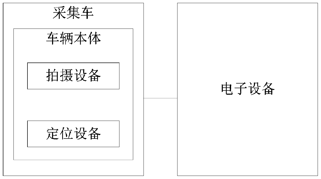
[0041] In order to clearly introduce the technical solutions of the embodiments of the present invention, based on Figure 1a A schematic structural diagram of a lane line updating system applicable to an embodiment of the present invention is introduced. Figure 1a Among them, the lane update system mainly includes electronic equipment and collection vehicles.

[0042] Collection vehicles include but are not limited to cars, cars, buses and other road vehicles, and can be unmanned vehicles or manned vehicles. The collection vehicle includes: a vehicle body, a photographing device and a positioning device mounted on the vehicle body.

[0043] The photographing device and the positioning device can be arranged on the rearview mirror of the collection vehicle. The photographing device is used to photograph the road in front of the collection vehicle, for example, a wide-angle camera, a fisheye camera, and the like. The positioning device is used for real-time positioning of the...

Embodiment 2

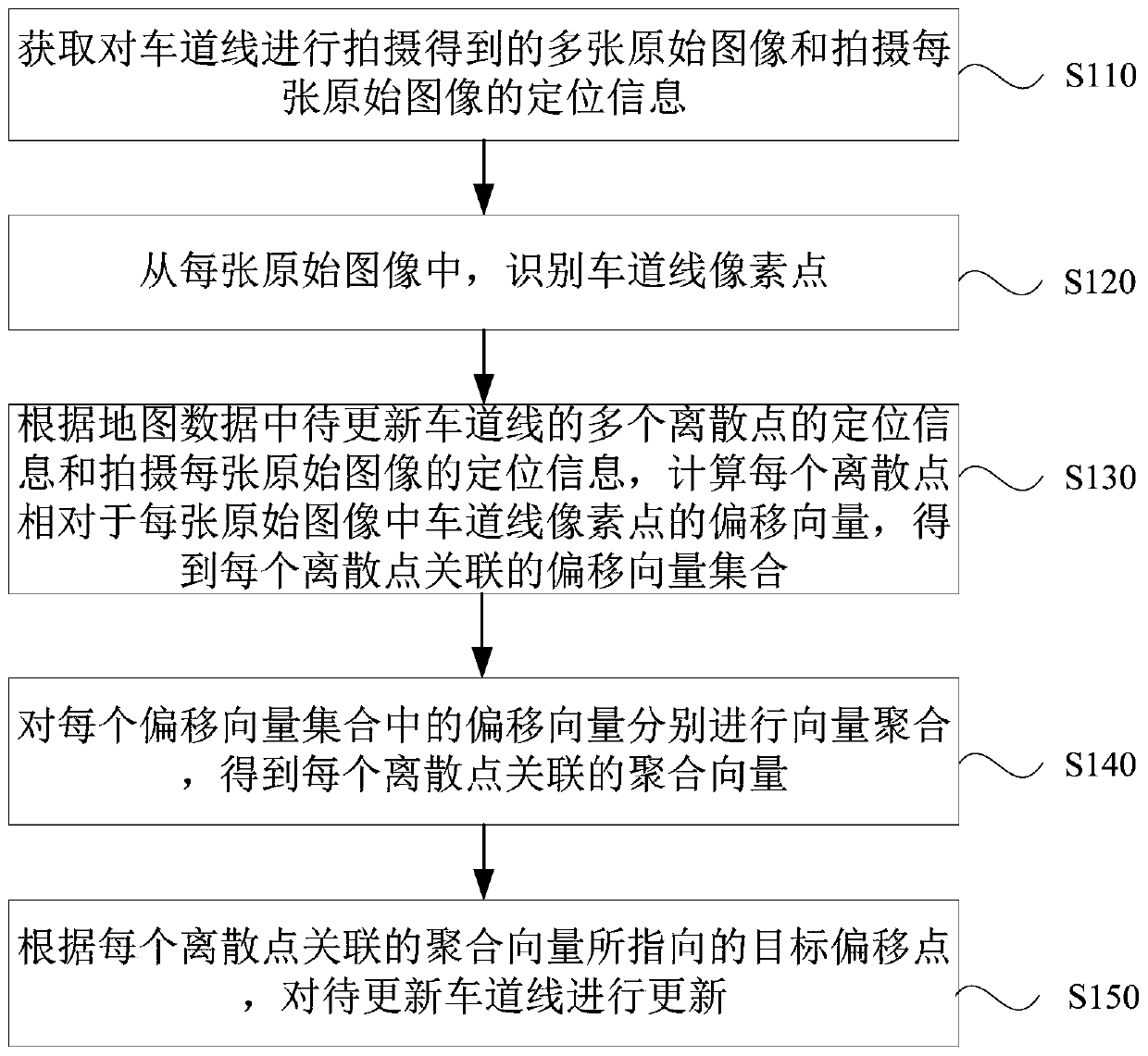
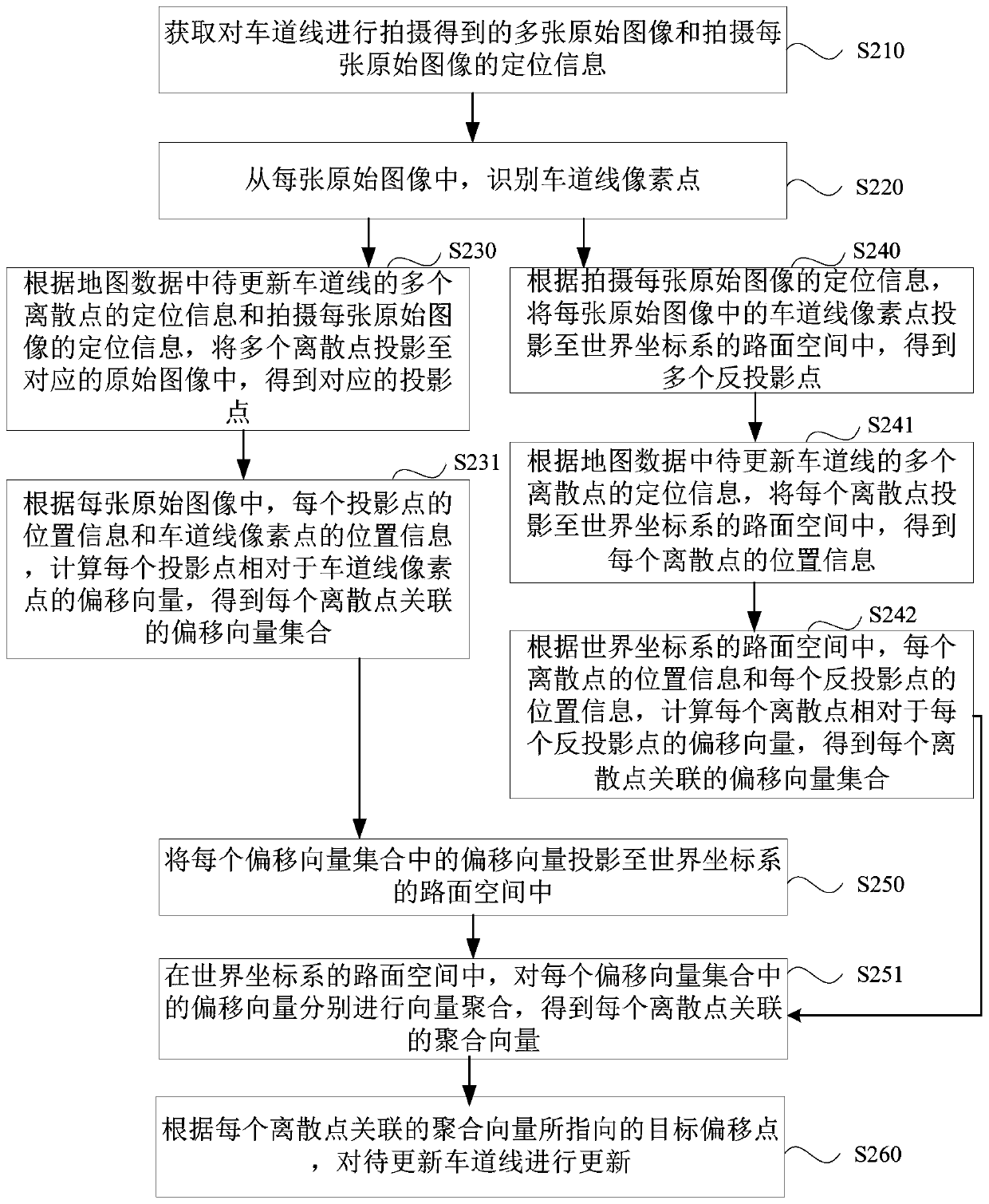
[0067] This embodiment is further optimized on the basis of the optional implementation manners of the foregoing embodiments. Optionally, "according to the positioning information of multiple discrete points of the lane line to be updated in the map data and the positioning information of each original image, calculate the deviation of each discrete point relative to the pixel point of the lane line in each original image According to the positioning information of multiple discrete points of the lane line to be updated in the map data and the positioning information of each original image taken, multiple discrete points are projected To the corresponding original image, the corresponding projection point is obtained; according to the position information of each projection point and the position information of the pixel point of the lane line in each original image, calculate the offset of each projection point relative to the pixel point of the lane line Vector to get the se...

Embodiment 3

[0122] The embodiments of the present invention perform operation optimization on the basis of the technical solutions of the foregoing embodiments. Optionally, the operation "perform vector aggregation on the offset vectors in each set of offset vectors to obtain the aggregation vector associated with each discrete point" is optimized as "aggregate the offset vectors in each set of offset vectors Add vectors to get the aggregation vector associated with each discrete point", or, optimize to "calculate the projection of the lane line pixel corresponding to each offset vector in each offset vector set in the road space of the world coordinate system point; according to the positioning information of each projection point and the positioning information of the original image where each projection point is located, calculate the distance between each projection point and the shooting point of the corresponding original image; according to each projection point and the correspondin...


PUM


Abstract

The embodiment of the invention provides a lane line updating method, device, equipment and system and a readable storage medium. The method comprises the following steps: obtaining a plurality of original images obtained by shooting lane lines and positioning information of each shot original image; identifying lane line pixel points from each original image; according to the positioning information of a plurality of discrete points of the lane line to be updated in the map data and the positioning information of each shot original image, calculating an offset vector of each discrete point relative to a lane line pixel point in each original image, and obtaining an offset vector set associated with each discrete point; performing vector aggregation on the offset vectors in each offset vector set to obtain an aggregation vector associated with each discrete point; and updating the lane line to be updated according to the target offset point pointed by the aggregation vector associatedwith each discrete point. According to the method provided by the embodiment of the invention, errors caused by single offset are eliminated, the cost is low, the stability is high, and the occurrenceis high.

Description

technical field [0001] Embodiments of the present invention relate to high-precision map technology, and in particular to a lane line updating method, device, equipment, system, and readable storage medium. Background technique [0002] High-definition map, also known as high-resolution map (High Definition Map, HD Map), is a map specially designed for driverless driving. Different from traditional navigation maps, HD maps can provide lane (Lane) level navigation information in addition to road (Road) level navigation information. In the real scene, due to road widening or re-planning, the lane lines also change accordingly, and it is necessary to update the lane lines in the high-precision map. [0003] At present, the update method of lane lines in high-precision maps is to collect lane line images through a collection vehicle equipped with high-precision Global Positioning System (Global Positioning System, GPS), inertial measurement unit (Inertial measurement unit, IMU)...

Claims


Application Information

Patent Timeline
Patent Type & Authority Applications(China)
IPC IPC(8): G06F16/23G06F16/29
CPCG06F16/23G06F16/29
Inventor 高超蔡育展郑超
Owner BEIJING BAIDU NETCOM SCI & TECH CO LTD
Why Eureka
Try Eureka