Coal mine water exploration drilling positioning method based on image recognition

A positioning method and image recognition technology, which can be applied in drilling equipment and methods, underwater drilling, earth-moving drilling, etc., and can solve problems such as time-consuming and labor-intensive

Active Publication Date: 2019-08-23
JINGYING SHUZHI TECH HLDG CO LTD
View PDF6 Cites 3 Cited by
  • Summary
  • Abstract
  • Description
  • Claims
  • Application Information

AI Technical Summary

Problems solved by technology

[0004] In order to overcome the time-consuming and labor-intensive defects of manual measurement and verification of drilling parameters after the existing drilling operations are completed, the present invention provides an imag

Method used


Image

  • Coal mine water exploration drilling positioning method based on image recognition
  • Coal mine water exploration drilling positioning method based on image recognition
  • Coal mine water exploration drilling positioning method based on image recognition

Examples


Embodiment 1

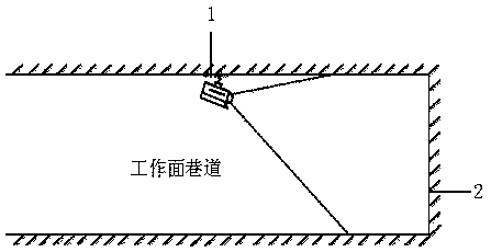
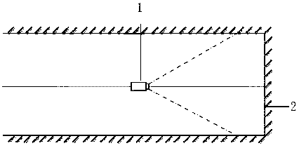
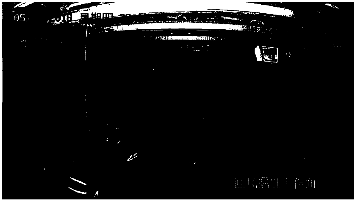
[0028] Such as Figures 1 to 6 As shown, a coal mine water detection drilling positioning method based on image recognition specifically includes the following steps: when drilling, the mine high-definition explosion-proof camera 1 is used to collect video images of the head-on area 2 and the bottom working area of ​​the entire working face, After the video picture collection is completed, the mining high-definition explosion-proof camera 1 uploads the video picture to the host computer through the network, and the host computer uses video picture analysis software to identify the video picture, and forms a coordinate system on the recognized video picture , and then judge the intersection point of the drill pipe and the head-on through the coordinate system on the video screen, and then calculate the specific position of the drill hole at the head-on, and calculate various drilling parameters.

[0029] Further, the video picture analysis software first opens the video picture...

Embodiment 2

[0035] Such as Figures 1 to 5 As shown, a coal mine water detection drilling positioning method based on image recognition specifically includes the following steps: when drilling, the mine high-definition explosion-proof camera 1 is used to collect video images of the head-on area 2 and the bottom working area of ​​the entire working face, After the video picture collection is completed, the mining high-definition explosion-proof camera 1 uploads the video picture to the host computer through the network, and the host computer uses video picture analysis software to identify the video picture, and forms a coordinate system on the recognized video picture , and then judge the intersection point of the drill pipe and the head-on through the coordinate system on the video screen, and then calculate the specific position of the drill hole at the head-on, and calculate various drilling parameters.

[0036] Further, the video picture analysis software first opens the video picture...

Embodiment 3

[0043] Such as Figures 1 to 5 As shown, a coal mine water detection drilling positioning method based on image recognition specifically includes the following steps: when drilling, the mine high-definition explosion-proof camera 1 is used to collect video images of the head-on area 2 and the bottom working area of ​​the entire working face, After the video picture collection is completed, the mining high-definition explosion-proof camera 1 uploads the video picture to the host computer through the network, and the host computer uses video picture analysis software to identify the video picture, and forms a coordinate system on the recognized video picture , and then judge the intersection point of the drill pipe and the head-on through the coordinate system on the video screen, and then calculate the specific position of the drill hole at the head-on, and calculate various drilling parameters.

[0044] Further, the video picture analysis software first opens the video picture i...


PUM

PropertyMeasurementUnit
Length and widthaaaaaaaaaa

Abstract

The invention provides a coal mine water exploration drilling positioning method based on image recognition. The method specifically comprises the following steps that when drilling operation is carried out, video pictures of a head-on area and a bottom working area of the whole working face are collected through a mining high-definition explosion-proof camera, after the video pictures are collected, the mining high-definition explosion-proof camera uploads the video pictures to an upper computer through a network, the upper computer identifies the video pictures through video picture analysissoftware, a coordinate system is formed on the identified video pictures, the intersection point of a drill rod and the head-on area is judged through the coordinate system on the video pictures, sothat the specific position of a drill hole at the head-on area can be calculated, and the parameters of each drill hole can be calculated. The method solves the problems that in the existing drillingoperation, manual measurement and verification of drilling parameters are needed after holes are formed, and time and labor are wasted. The method can ensure that the drilling parameters conform to the drilling design, automatic supervision is achieved, the operation of manual hole inspection is reduced, the safety of coal mine operation is ensured, and time and labor are saved.

Description

technical field [0001] The invention belongs to the field of borehole positioning for underground drilling in coal mines, and in particular relates to an image recognition-based coal mine water detection borehole positioning method. Background technique [0002] The main threats to coal mine safety are gas and water hazards. At present, the water hazards in Shanxi Province are controlled by drilling to survey the underground geology and water storage, and carry out corresponding disposal, and then excavate after confirming safety. Exploring and releasing water includes two aspects: exploring water and releasing water. Water exploration refers to the use of advanced exploration methods in the mining process to find out the specific spatial location and status of water bodies such as the roof, floor, side and front of the mining face, etc. The purpose is to make necessary preparations for effective prevention and control of mine water. Release of water refers to the release o...

Claims


Application Information

Patent Timeline
IPC IPC(8): E21B7/04E21B7/12E21B47/00E21B47/002G06Q50/02
CPCE21B7/043E21B7/12E21B47/00E21B47/002E21B47/022G06Q50/02
Inventor 吴喆峰卢慧峰赵存会王延辉
Owner JINGYING SHUZHI TECH HLDG CO LTD
Why Eureka
Try Eureka