Urban heat island master control factor analysis method and device and storage medium

An urban heat island and main control factor technology, applied in data processing applications, forecasting, instruments, etc., can solve the problems of low algorithm accuracy, failure to consider the impact factors on urban heat island, and inability to meet the needs of rapid and high-precision mining of urban heat island control factors.

Pending Publication Date: 2019-08-30
GUANGZHOU UNIVERSITY
View PDF4 Cites 5 Cited by
  • Summary
  • Abstract
  • Description
  • Claims
  • Application Information

AI Technical Summary

Problems solved by technology

However, during the research and practice of the prior art, the inventors of the present invention found that the prior art is generally based on the linear regression analysis of the global least squares method, so as to estimate the global parameters of the influen

Method used


Image

  • Urban heat island master control factor analysis method and device and storage medium
  • Urban heat island master control factor analysis method and device and storage medium
  • Urban heat island master control factor analysis method and device and storage medium

Examples


no. 1 example

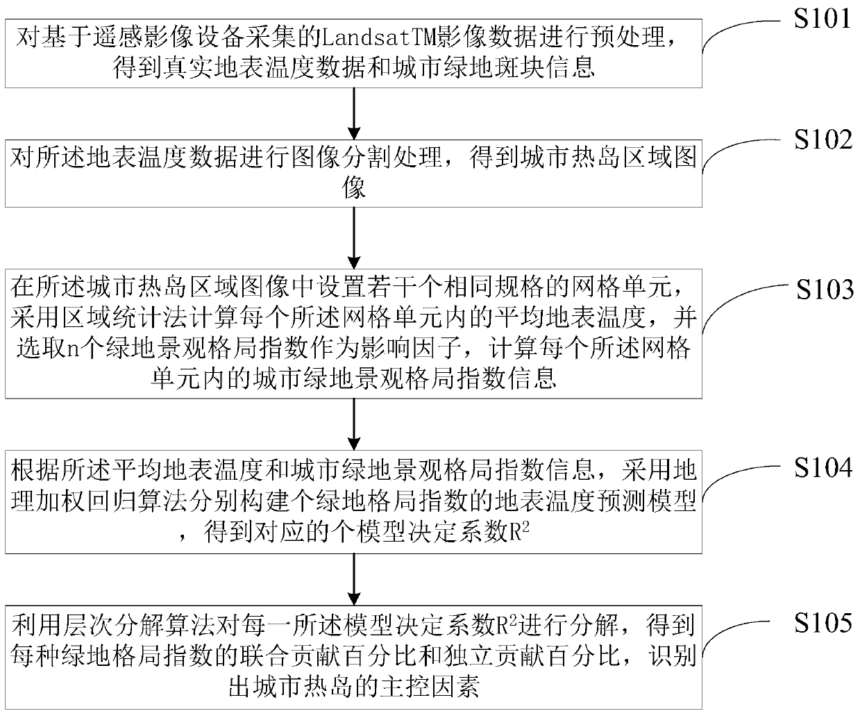
[0048] see Figure 1-4 .

[0049] like figure 1 As shown, the method for analyzing the main controlling factors of an urban heat island provided in this embodiment is suitable for execution in computer equipment, and includes the following steps:

[0050] S101. Preprocessing the Landsat TM image data collected based on remote sensing image equipment to obtain real surface temperature data and urban green patch information;

[0051] In a preferred embodiment, the pretreatment is specifically:

[0052] Using the first formula to convert Landsat TM image data collected based on remote sensing image equipment into real surface temperature data;

[0053] The Landsat TM image is classified into landscape types by using the object-oriented method, and the urban green patch information is extracted.

[0054] Specifically, image segmentation is performed on the surface temperature data, and an aggregation analysis algorithm is used to calculate the aggregation characteristics of th...

no. 2 example

[0077] see Figure 2-5 .

[0078] like Figure 5 As shown, this embodiment also provides an analysis device for the main controlling factors of urban heat island, including:

[0079] The data preprocessing module 100 is used to preprocess the Landsat TM image data collected based on the remote sensing image equipment to obtain real surface temperature data and urban green patch information;

[0080] An image segmentation module 200, configured to perform image segmentation processing on the surface temperature data to obtain an urban heat island image;

[0081] Specifically, for the image segmentation module 200, according to the feature of the surface temperature image, the segmentation scale is set to 5, and the complexity coefficient is set to 0.3 to obtain the surface temperature segmentation unit. Then the agglomeration analysis algorithm is used to calculate the agglomeration characteristics of the surface temperature segmentation units to obtain the urban heat island...


PUM


Abstract

The invention discloses an urban heat island master control factor analysis method and device and a storage medium. The method comprises the following steps of preprocessing the acquired Landsat TM image data, and carrying out image segmentation after obtaining the real surface temperature data and the urban green land plaque information; after the urban heat island area image is obtained, arranging the grid units, calculating the average surface temperature in each grid unit, selecting n greenbelt landscape pattern indexes as the influence factors, and calculating the urban greenbelt landscape pattern index information in each grid unit; and according to the average surface temperature and the urban greenbelt landscape pattern index information, constructing a surface temperature prediction model of the greenbelt pattern index, and decomposing the model decision coefficient R2 to obtain a joint contribution percentage and an independent contribution percentage of each greenbelt pattern index, thereby identifying the main control factors of an urban heat island. According to the method, the spatial heterogeneity of the urban heat island and the influence factors thereof can be considered, and the rapid and high-precision mining of the urban heat island control factors is achieved.

Description

technical field [0001] The invention relates to the technical field of environmental monitoring, in particular to an analysis method, device and storage medium for the main control factors of urban heat islands. Background technique [0002] In the context of rapid urbanization, the urban heat island effect, one of the main characteristics of urban climate, is becoming more and more serious. The wide application of remote sensing data has made it possible to analyze the causes of heat island effects at different scales. A large number of research results have shown that the composition and configuration patterns of urban impervious surfaces, vegetation, water bodies and other landscapes play an important role in the formation and development of heat islands. Therefore, finding an efficient and accurate mining method for the main controlling factors of urban heat island and quickly locating the urban planning parameters that affect urban heat island are of great significance ...

Claims


Application Information

Patent Timeline
IPC IPC(8): G06Q10/04G06Q50/26
CPCG06Q10/04G06Q50/26Y02A30/60
Inventor 郭冠华吴志峰陈颖彪
Owner GUANGZHOU UNIVERSITY
Why Eureka
Try Eureka