Adcp assisted sins navigation method for manned deep submersible

A technology of a manned submersible and a navigation method, applied in the field of high-precision underwater navigation and positioning

Active Publication Date: 2020-11-20
SOUTHEAST UNIV
View PDF6 Cites 0 Cited by
  • Summary
  • Abstract
  • Description
  • Claims
  • Application Information

AI Technical Summary

Problems solved by technology

[0005] Purpose of the invention: Aiming at the problems that both GPS and DVL are unavailable in middle waters and SINS positioning errors accumulate over time, the present invention proposes an ADCP-assisted SINS navigation method for deep-diving manned submersibles to realize the submersible / surfacing of deep-diving manned submersibles Fully autonomous high-precision navigation and positioning during the process

Method used


Image

  • Adcp assisted sins navigation method for manned deep submersible
  • Adcp assisted sins navigation method for manned deep submersible
  • Adcp assisted sins navigation method for manned deep submersible

Examples


Embodiment Construction

[0065] The technical solution of the present invention will be further described below in conjunction with the accompanying drawings.

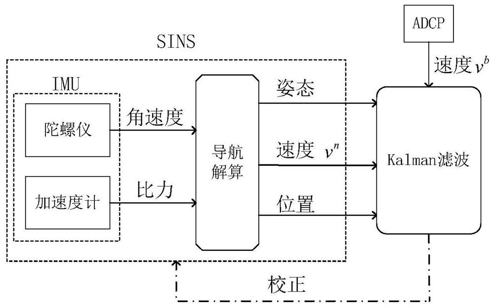
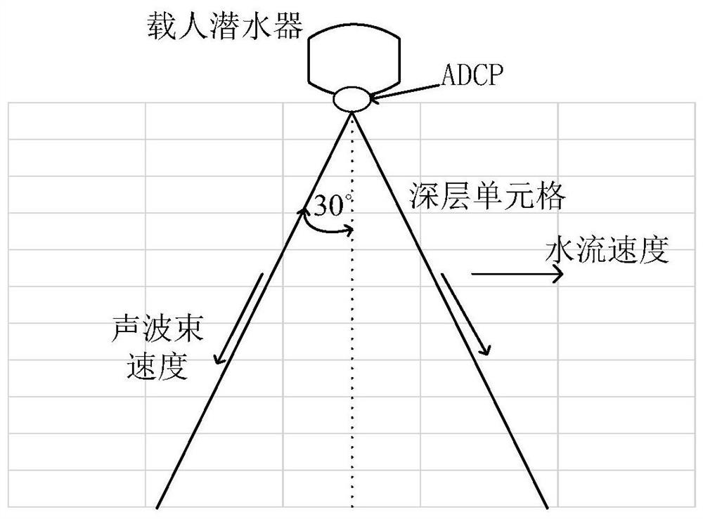
[0066] The present invention uses the ADCP installed at the bottom of the manned submersible to measure the velocity of the manned submersible relative to the water flow without considering the acoustic positioning system, and further uses the overlapping ADCP measurements to deduce the ground velocity and the water flow velocity profile at different depths ; Through the kalman filter technology, the obtained ground speed and the navigation parameters output by SINS are fused together to form a speed matching integrated navigation to suppress the divergence of SINS positioning errors, so as to realize the full autonomy of the deep-diving manned submersible in the process of diving / surfacing high-precision navigation and positioning. Such as figure 1 Shown, a kind of deep submersible manned submersible ADCP assisted SINS navigation method of t...


PUM


Abstract

The invention discloses an ADCP-assisted SINS navigation method for a deep-diving manned submersible, comprising the following steps of: 1) using angular motion and linear motion measurement provided by an inertial measurement unit mounted on a manned submersible as an input of a SINS, executing a navigation solution algorithm to output the navigation solutions of the SINS, namely the attitude, the speed and the position; 2) measuring, by the ADCP installed at the bottom of the manned submersible, the speed of the manned submersible relative to a water flow, and measuring and deriving, by means of the overlapped ADCP, the ground speed of the manned submersible and the speed of the water flow; and 3) by means of kalman filtering, fusing the SINS navigation solutions in the step 1 with the ground speed of the manned submersible obtained in the step 2 to form SINS / ADCP combined navigation to suppress SINS error divergence. The method solves the problem that GPS and DVL are not available in midwater and the SINS positioning errors accumulate with time, and can realize the completely independent high-precision navigation and positioning of the deep-diving manned submersible in the diving / coming up process.

Description

technical field [0001] The invention relates to the technical field of high-precision underwater navigation and positioning, in particular to an ADCP-assisted SINS navigation method for a deep-submersible manned submersible, which is particularly suitable for mid-water navigation of underwater vehicles. Background technique [0002] The manned submersible is an important vehicle for scientific research and survey operations in the deep sea. It has the advantages of allowing people to visit the scene and give full play to people's subjective initiative. It is called "an important cornerstone in the field of oceanographic research." High-precision navigation and positioning is an essential condition for manned submersibles to operate in complex deep-sea environments, but high-reliability, high-stability, and high-precision underwater navigation is also a major challenge. On the water surface, the Global Navigation Satellite System (Global Navigation Satellite System, GNSS) can...

Claims


Application Information

Patent Timeline
Patent Type & Authority Patents(China)
IPC IPC(8): G01C21/16G01C21/18
CPCG01C21/165G01C21/18
Inventor 刘锡祥刘贤俊王艺晓童金武沈航曾继超汤高宇黄永江马晓爽刘剑威
Owner SOUTHEAST UNIV
Why Eureka
Try Eureka