Unmanned aerial vehicle path planning method taking laser scanning as constraint

A technology of path planning and laser scanning, which is applied in the directions of measuring devices, instruments, surveying and navigation, etc., can solve the problems of areas lacking geographical environment information, complex algorithms, and planning paths that cannot reach the global optimum.

Active Publication Date: 2019-10-01
GUIZHOU POWER GRID CO LTD
View PDF19 Cites 4 Cited by
  • Summary
  • Abstract
  • Description
  • Claims
  • Application Information

AI Technical Summary

Problems solved by technology

[0003] The technical problem to be solved by the present invention is to provide a UAV path planning method constrained by laser scanning, so as to solve the problem that in the prior art for UAV path planning, the local path planning method is adopted, and the planned path cannot reach the global optimum. Excellent; the global planning method can avoid risks in advance and plan the optimal flight path, but it needs the support of detailed geographic environment information, so the algorithm is more complicated, and it is not suitable for problems such as areas lacking geographic environment information

Method used


Image

  • Unmanned aerial vehicle path planning method taking laser scanning as constraint
  • Unmanned aerial vehicle path planning method taking laser scanning as constraint
  • Unmanned aerial vehicle path planning method taking laser scanning as constraint

Examples


Embodiment Construction

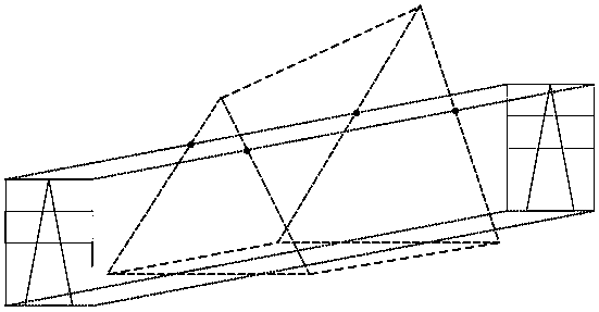
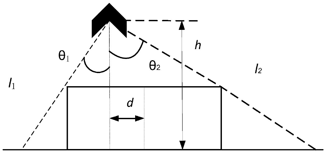
[0025] The invention solves the path planning problem of the unmanned aerial vehicle under the constraint condition of laser scanning. Taking the minimum voyage as the path cost function, define the detection space between the two towers as a cuboid, construct a restriction strategy for measuring the angle of the laser sensor, measuring the maximum distance of the ground target, and the lateral distance between the UAV and the tower, so as to ensure that the UAV laser The scan area coincides with the cuboid area.

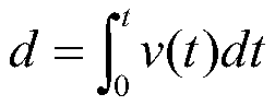
[0026] First, set the position of the UAV at time t as (x(t), y(t), z(t)), and the speed of the UAV as v(t), then the expression of the flight range d of the UAV is as follows:

[0027]

[0028] The UAV planning cost function J(t) is set as follows:

[0029]

[0030] Then, define the detection interval between the two towers as a cuboid. In order to ensure the integrity of the tower information, the height of the cuboid is set as the height of the tower, the...


PUM


Abstract

The invention discloses an unmanned aerial vehicle path planning method taking laser scanning as a constraint. The method comprises the following steps: 1, setting a position of an unmanned aerial vehicle at a moment t to be (x(t),y(t),z(t)) and a speed of the unmanned aerial vehicle to be v(t), and establishing an expression for a flight d of the unmanned aerial vehicle and an expression for an unmanned aerial vehicle planning cost function; 2, defining a detection interval between two pole towers as a rectangular solid; 3, inputting starting point coordinates and end point coordinates duringunmanned aerial vehicle path planning, and performing path planning by using a fast search tree algorithm; and 4, outputting a planned path result. The method disclosed by the invention solves the effectiveness problem of the laser scanning of the unmanned aerial vehicle, the problem that a planned path can not achieve global optimum as a local path planning method is adopted in the unmanned aerial vehicle path planning and the problems that an algorithm is relatively complex and a global planning method is not applicable to a region lack of geographical environmental information as the global planning method needs detailed geographical environmental information support.

Description

technical field [0001] The invention belongs to the UAV path planning technology, in particular to a UAV path planning method constrained by laser scanning. Background technique [0002] Different UAV application platforms correspond to different path planning methods. The terrain of the mountainous environment is complex, and path planning needs to consider avoiding obstacles. The global planning method or the local planning method can be used. The local path planning method is suitable for the situation where the spatial information of the flight planning is insufficient and the global environment cannot be accurately modeled. The basic idea is to use local information to plan the next execution action to avoid risks such as collisions, but the planning path cannot reach the global optimum. The global planning method can avoid risks in advance and plan the optimal flight path, but it needs the support of detailed geographic environment information, so the algorithm is mo...

Claims


Application Information

Patent Timeline
Patent Type & Authority Applications(China)
IPC IPC(8): G01C21/00
CPCG01C21/005Y02T10/40
Inventor 杨磊石书山陈科羽周小红张伟杜昊陈凤翔谢皓凌李文涛石蕾陈海华刘博迪
Owner GUIZHOU POWER GRID CO LTD
Why Eureka
Try Eureka