iBeacon and GPS-based outdoor positioning tourism navigation system

An external positioning and subsystem technology, applied in the field of outdoor positioning travel guide system, can solve problems such as difficulty in understanding the location information of the scenic spots and surrounding scenic spots, and unfamiliar scenic spots

Active Publication Date: 2019-10-25
BEIJING UNIV OF POSTS & TELECOMM
View PDF32 Cites 3 Cited by
  • Summary
  • Abstract
  • Description
  • Claims
  • Application Information

AI Technical Summary

Problems solved by technology

The guide system mainly solves the following two problems: 1. Tourists are not familiar with the scenic spots in the scenic spots with complex environment, and it is difficult to know the location information of the scenic spots where they are and surrounding scenic spots, so as to plan their own itinerary

Method used


Image

  • iBeacon and GPS-based outdoor positioning tourism navigation system

Examples


Embodiment Construction

[0069] The present invention will be described in further detail below in conjunction with the accompanying drawings and embodiments.

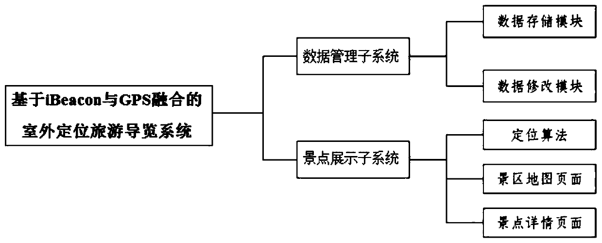
[0070] Such as figure 1 As shown, an outdoor positioning tour guide system based on iBeacon and GPS, including: a scenic spot management subsystem and a scenic spot display subsystem;

[0071] The scenic spot management subsystem is: a system running on a cloud server, and the scenic spot management subsystem is used to: provide data for the scenic spot display subsystem;

[0072] The data includes: text, pictures and audio, etc.;

[0073] The scenic spot management subsystem includes: a data storage module and a data modification module

[0074] Described data storage module is used for: storing the scenery photo of each scenic spot in the scenic spot, introduction content, commentary audio frequency, the polygon range of scenic spot, the center position of scenic spot, the latitude and longitude of scenic spot positioning point, and store ...


PUM


Abstract

The invention belongs to the technical field of scenic spot navigation, and relates to an iBeacon and GPS-based outdoor positioning tourism navigation system. The system comprises a scenic spot management subsystem and a scenic spot display subsystem. The scenic spot display subsystem comprises a GPS positioning algorithm and an iBeacon positioning algorithm. According to the invention, iBeacon and GPS fusion-based precise positioning is adopted, so that the accuracy of tourist positioning is improved. The automatic switching to a current scenic spot is realized. The all-dimensional and multi-angle display information such as characters, pictures and audios is provided for tourists, data are modified, added and deleted at any time, scenic spot changes are adapted in real time. Particularly, a character-to-voice technology is applied to upload explanation characters to automatically generate explanation audios. According to the iBeacon and GPS-based outdoor positioning tourism navigation system, the burden of a tour guide is reduced, and the labor cost is saved. The comprehensive and detailed scenic spot introduction is brought to tourists. The touring experience is improved, and benefits are created for scenic spots.

Description

technical field [0001] The invention belongs to the technical field of scenic spot guides, and relates to an outdoor positioning tour guide system based on iBeacon and GPS. Background technique [0002] In the patent with the publication number CN 109064951 A, it relates to the technical field of scenic spot navigation system, specifically a scenic spot explanation system based on a WeChat applet, including a scenic spot control system. The scenic spot control system includes five groups of systems, the five The group system is set as a scenic spot map system, a scenic spot road condition system, a scenic spot wireless control system, a voice control system and a scenic spot alarm system. The road condition system of the scenic spot is used for real-time monitoring and broadcasting functions of the road section leading to the scenic spot inside the scenic spot. The above-mentioned invention can enable tourists to more comprehensively understand the map scenic spot of the sce...

Claims


Application Information

Patent Timeline
Patent Type & Authority Applications(China)
IPC IPC(8): G09F27/00G06F16/29G06Q50/14
CPCG06Q50/14G09F27/00G06F16/29
Inventor 郭泽瑞尹旭然钟媛媛戴志涛徐萨王景辉
Owner BEIJING UNIV OF POSTS & TELECOMM
Why Eureka
Try Eureka