Navigation system and navigation map updating method and device

A navigation map and update method technology, applied in the field of navigation, can solve the problems of large data volume, long collection time, and non-real-time update of navigation maps, and achieve the effects of reducing burden and time, improving navigation data, and speeding up updates

Active Publication Date: 2019-10-29
BYD CO LTD
View PDF7 Cites 5 Cited by
  • Summary
  • Abstract
  • Description
  • Claims
  • Application Information

AI Technical Summary

Problems solved by technology

[0003] However, traditional navigation software is generally updated by connecting to devices such as USB, or by connecting to a server through a network to compare versions. If the version of the current car navigation system is better than the version on the map server, it will be upgraded.
Moreover, navigation data needs to be collected. The collection method is usually that map manufacturers build their own collection vehicles to collect road conditions in various districts. However, China has a vast land, so the collection time must be very long and the amount of data is large.
As a result, the update of the navigation map is not real-time, which may lead to deviations between the data of the vehicle navigation map and the actual road conditions

Method used


Image

  • Navigation system and navigation map updating method and device
  • Navigation system and navigation map updating method and device
  • Navigation system and navigation map updating method and device

Examples


Embodiment Construction

[0024] The present invention will be described in detail below, examples of which are shown in the accompanying drawings, wherein the same or similar reference numerals designate the same or similar elements or elements having the same or similar functions throughout. The following description by referring to the accompanying drawings is exemplary and is intended to explain the present invention and should not be construed as limiting the present invention.

[0025] The method for updating the navigation map and the navigation system according to the embodiments of the present invention will be described below with reference to the accompanying drawings.

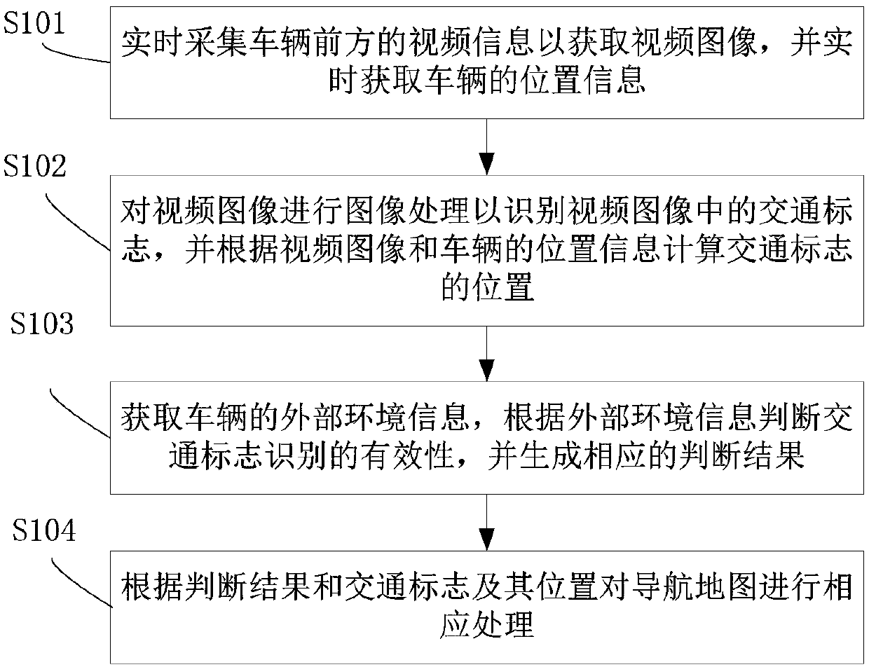
[0026] figure 1 is a flowchart of a method for updating a navigation map according to an embodiment of the present invention.

[0027] Such as figure 1 As shown, the method for updating the navigation map includes the following steps:

[0028] S101. Collect video information in front of the vehicle to obtain a video image...


PUM


Abstract

The invention discloses a navigation system and a navigation map updating method and device. The method comprises the following steps of: collecting the video information ahead of a vehicle to acquirea video image, and acquiring the location information of the vehicle; processing the video image to identify a traffic sign in the video image, and calculating the location of the identified trafficsign according to the video image and the location information of the vehicle; acquiring the external environmental information of the vehicle, determining the validity of the identified traffic signaccording to the external environmental information, and generating a corresponding determination result; and correspondingly processing the navigation map according to the determination result and the identified traffic sign and its location. The method helps to improve the navigation data, accelerates the updating of the navigation map, makes the navigation traffic sign data accurate and effective, and can reduce the burden and time of the map manufacturer data collection.

Description

technical field [0001] The invention relates to the technical field of navigation, in particular to a navigation map updating method, a navigation map updating device and a navigation system. Background technique [0002] With the continuous development of science and technology, intelligent vehicle driving has gradually become a reality. The detection, recognition and tracking algorithms based on traffic signs such as traffic lights provide great help for current vehicle driving (including manned and unmanned driving). Specifically, the image information outside the vehicle is collected through the camera, and the geometric information such as the position and shape of the space object can be calculated according to the image information, so as to achieve the purpose of describing and identifying the space object in the environment; the path can be planned through the vehicle navigation software, and Prompt the corresponding information according to the traffic signs on th...

Claims


Application Information

Patent Timeline
IPC IPC(8): G01C21/30G01C21/36
CPCG01C21/30G01C21/3667
Inventor 高上添
Owner BYD CO LTD
Why Eureka
Try Eureka