Monocular vision based measurement method for terrain clearance of unmanned aerial vehicle

A technology of ground clearance and measurement method, which is applied in height/horizontal measurement, measuring device, surveying and navigation, etc., can solve the problem that the definition evaluation function does not have a good effect, and meet the real-time requirements and reduce the amount of calculation , the effect of a large range of use

Active Publication Date: 2019-11-15
NO 20 RES INST OF CHINA ELECTRONICS TECH GRP
View PDF14 Cites 15 Cited by
  • Summary
  • Abstract
  • Description
  • Claims
  • Application Information

AI Technical Summary

Problems solved by technology

The sharpness evaluation function adopted by these methods does not have a good effect on the complex outdoor environment of UAVs.

Method used


Image

  • Monocular vision based measurement method for terrain clearance of unmanned aerial vehicle
  • Monocular vision based measurement method for terrain clearance of unmanned aerial vehicle
  • Monocular vision based measurement method for terrain clearance of unmanned aerial vehicle

Examples


Embodiment

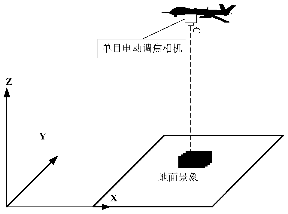
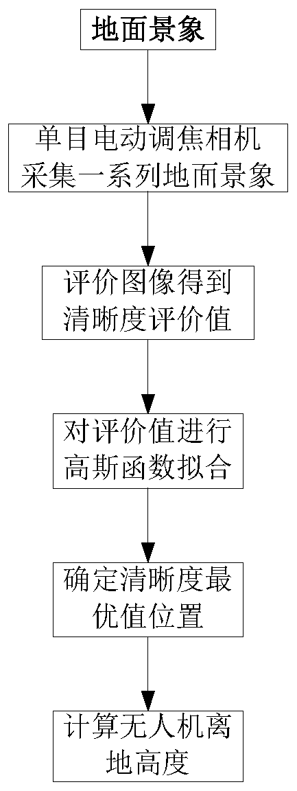
[0083] (1) Ground scene collection: When the UAV is flying in the air and measuring the height at a certain position, adjust the image distance of the monocular electric focusing camera, and use the depth of field of the electric focusing camera as the adjustment step. Acquire a ground scene image at a distance, and acquire a series of ground scene images within the adjustable range of the electric focusing camera. While acquiring the ground scene, record the image distance of each image corresponding to the focusing camera.

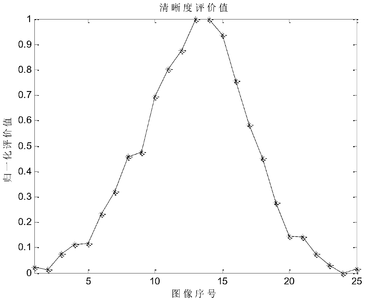
[0084] (2) Clarity evaluation: The motorized focusing camera obtains images of different resolutions by adjusting the image distance. The clear images are clear at the edges and details, with sharper edges and richer details, and more high-frequency energy , an image with more high-frequency energy will be relatively clearer than an image with less high-frequency energy, so the image clarity can be evaluated by the amount of energy in the high-frequency ...


PUM


Abstract

The invention provides a monocular vision based measurement method for terrain clearance of an unmanned aerial vehicle. A series of ground scene images are acquired by a monocular electric focusing camera vision sensor, a definition evaluation function is proposed by utilizing the characteristic of high proportion of high-frequency energy of clear images, the images are evaluated on the basis of the proposed definition evaluation function, terrain clearance of the unmanned aerial vehicle is completed according to evaluation results, and height information is provided for landing, ascending ordescending of various small flying platforms such as unmanned aerial vehicles and the like. High-frequency energy is obtained with a gradient calculation method, image definition evaluation is realized by evaluating the amount of the high-frequency energy of the images; compared with direct calculation of a frequency domain, the method has a small calculation amount and meets the requirement of real-time performance of the system; compared with a gradient function, the evaluation results are described by frequency domain information, and noise resistance is better.

Description

technical field [0001] The invention relates to the field of photoelectric distance measurement. The monocular visual sensor is used to measure the height of the unmanned aerial vehicle from the ground. It can be used for landing, ascent or descent of various small flying platforms such as unmanned aerial vehicles, and can also be used for distance measurement of other visual platforms. for reference. Background technique [0002] Small drones have the characteristics of lightness and portability, flexible use scenarios, and low application costs. They are increasingly used in aerial photography, logistics and other fields. [0003] In order to realize autonomous landing of UAV or low-altitude flight in complex terrain environment, it is necessary to obtain the height information of UAV. The height data of the UAV is important information for UAV landing, ascent or descent, and anti-collision. Since the UAV has strict restrictions on equipment weight, power consumption, and...

Claims


Application Information

Patent Timeline
Patent Type & Authority Applications(China)
IPC IPC(8): G01C5/00G01C11/06G06T7/00
CPCG01C5/005G01C11/06G06T7/0002
Inventor 王健刘震梁永君
Owner NO 20 RES INST OF CHINA ELECTRONICS TECH GRP
Why Eureka
Try Eureka