Check patentability & draft patents in minutes with Patsnap Eureka AI!

Satellite-ground space-time maximum coverage problem solving method based on improved genetic algorithm

A technology of improved genetic algorithm and maximum coverage, which is applied in the field of solving the problem of maximum coverage of space-time and space based on improved genetic algorithm, and achieves the effect of small error, high algorithm efficiency and reduced solution time.

Pending Publication Date: 2019-11-15
CHINA UNIV OF GEOSCIENCES (WUHAN)
View PDF2 Cites 3 Cited by
  • Summary
  • Abstract
  • Description
  • Claims
  • Application Information

AI Technical Summary

Problems solved by technology

[0010] Step S1: Aiming at the problem of maximum space-time coverage, encode the facility layout scheme with decimal number strings

Method used


Image

  • Satellite-ground space-time maximum coverage problem solving method based on improved genetic algorithm
  • Satellite-ground space-time maximum coverage problem solving method based on improved genetic algorithm
  • Satellite-ground space-time maximum coverage problem solving method based on improved genetic algorithm

Examples


Embodiment Construction

[0031] The following will clearly and completely describe the technical solutions in the embodiments of the present invention with reference to the accompanying drawings in the embodiments of the present invention. Obviously, the described embodiments are only some, not all, embodiments of the present invention. Based on the embodiments of the present invention, all other embodiments obtained by persons of ordinary skill in the art without making creative efforts belong to the protection scope of the present invention.

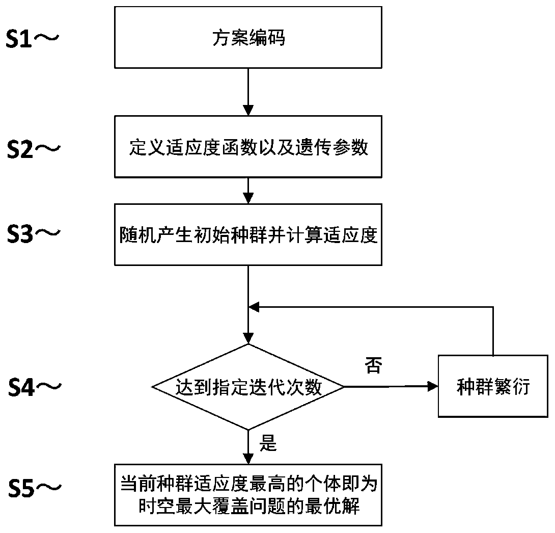
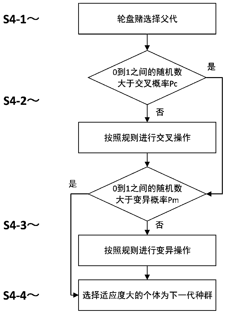
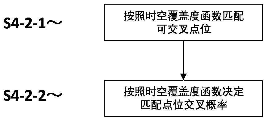
[0032] see Figure 1-3 , the present invention provides a technical solution: In this embodiment, aiming at the application scenario of site selection of rainfall gauge stations in the downstream area of ​​Jinsha River, the spatial discretization expression of the target monitoring area in the lower reaches of Jinsha River is carried out, and the grid size standard of 15kmx15km is passed through the network. Grid division converts the spatially continuous wate...


PUM


Abstract

The invention relates to the technical field of smart city geographic information service, in particular to a satellite-ground space-time maximum coverage problem solving method based on an improved genetic algorithm. According to the method, the problems of low efficiency and high time expenditure when a traditional optimization technology is used for solving the space-time maximum coverage problem of the satellite-ground sensor are solved, and a novel cross operator taking the space-time coverage degree as a core is designed based on a genetic algorithm and used for solving the space-time maximum coverage problem. Comparing traditional optimization techniques, ain the method, facilities with relatively small space-time coverage are preferentially selected for cross transformation in a genetic evolution process; excessive redundant coverage is effectively reduced, the algorithm can be prevented from falling into a premature convergence state, the solving efficiency of the algorithm isremarkably improved, the time overhead is reduced, and it is proved that the method is a practical and reliable method beneficial to improving the calculation efficiency in solving of the satellite-ground space-time maximum coverage problem.

Description

technical field [0001] The invention relates to the technical field of geographical information services for smart cities, in particular to a method for solving the maximum satellite-earth space-time coverage problem based on an improved genetic algorithm. Background technique [0002] Satellite remote sensing and ground observation are the two main means of obtaining earth observation data. However, due to the difference in observation mechanism, the coverage of the two has discontinuity in time and space. Space-borne sensors can provide Earth observation data in a wide range of areas, but due to constraints such as revisit cycles, time-continuous observations cannot be performed; on the contrary, ground-based sensors are a spatial sampling method based on discrete points, which can be continuous without interruption. Obtain observation data, but cannot directly obtain observation data of a large area. Therefore, using satellites or ground sensors alone cannot obtain conti...

Claims


Application Information

Patent Timeline
IPC IPC(8): G06K9/00G06N3/12
CPCG06N3/126G06V20/13
Inventor 王珂龚悦胡楚丽
Owner CHINA UNIV OF GEOSCIENCES (WUHAN)
Features
  • R&D
  • Intellectual Property
  • Life Sciences
  • Materials
  • Tech Scout
  • Unparalleled Data Quality
  • Higher Quality Content
  • 60% Fewer Hallucinations
Learn More