Method for identifying boundaries of urban active area and central urban area based on information data

A technology of boundary identification and information data, applied in the field of urban space identification research, can solve the problems of single index selection and lack of dynamic index, etc., and achieve the real effect

Active Publication Date: 2019-12-03
广州市交通规划研究院有限公司
View PDF7 Cites 19 Cited by
  • Summary
  • Abstract
  • Description
  • Claims
  • Application Information

AI Technical Summary

Problems solved by technology

[0005] Aiming at the deficiencies in the existing research on the identification of urban vitality areas and central city boundaries, such as single selection of indicators and lack of dynamic indicators, the purpose of the present invention is to provide a method for identifying the boundaries of urban vitality areas and central urban areas based on information data , this method is based on information data, adopts four dynamic and static indicators for comprehensive analysis, and based on the kernel density

Method used


Image

  • Method for identifying boundaries of urban active area and central urban area based on information data
  • Method for identifying boundaries of urban active area and central urban area based on information data
  • Method for identifying boundaries of urban active area and central urban area based on information data

Examples


Embodiment Construction

[0047] The present invention will be further described below in conjunction with specific examples, but the present invention is not limited to these specific implementations. Those skilled in the art will realize that the present invention covers all alternatives, modifications and equivalents as may be included within the scope of the claims.

[0048] The structural principle and working principle of the present invention will be specifically described below in conjunction with the accompanying drawings.

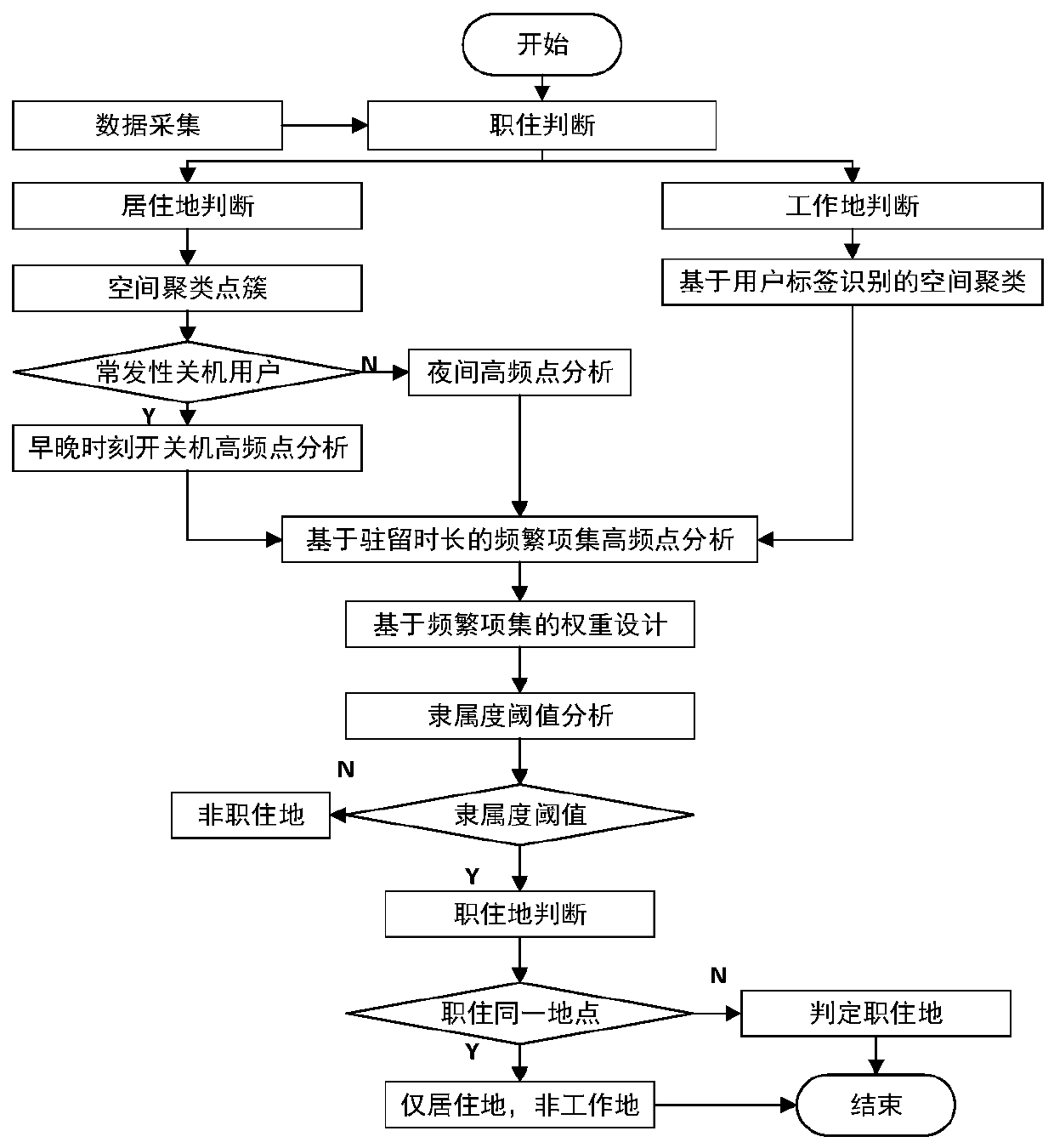
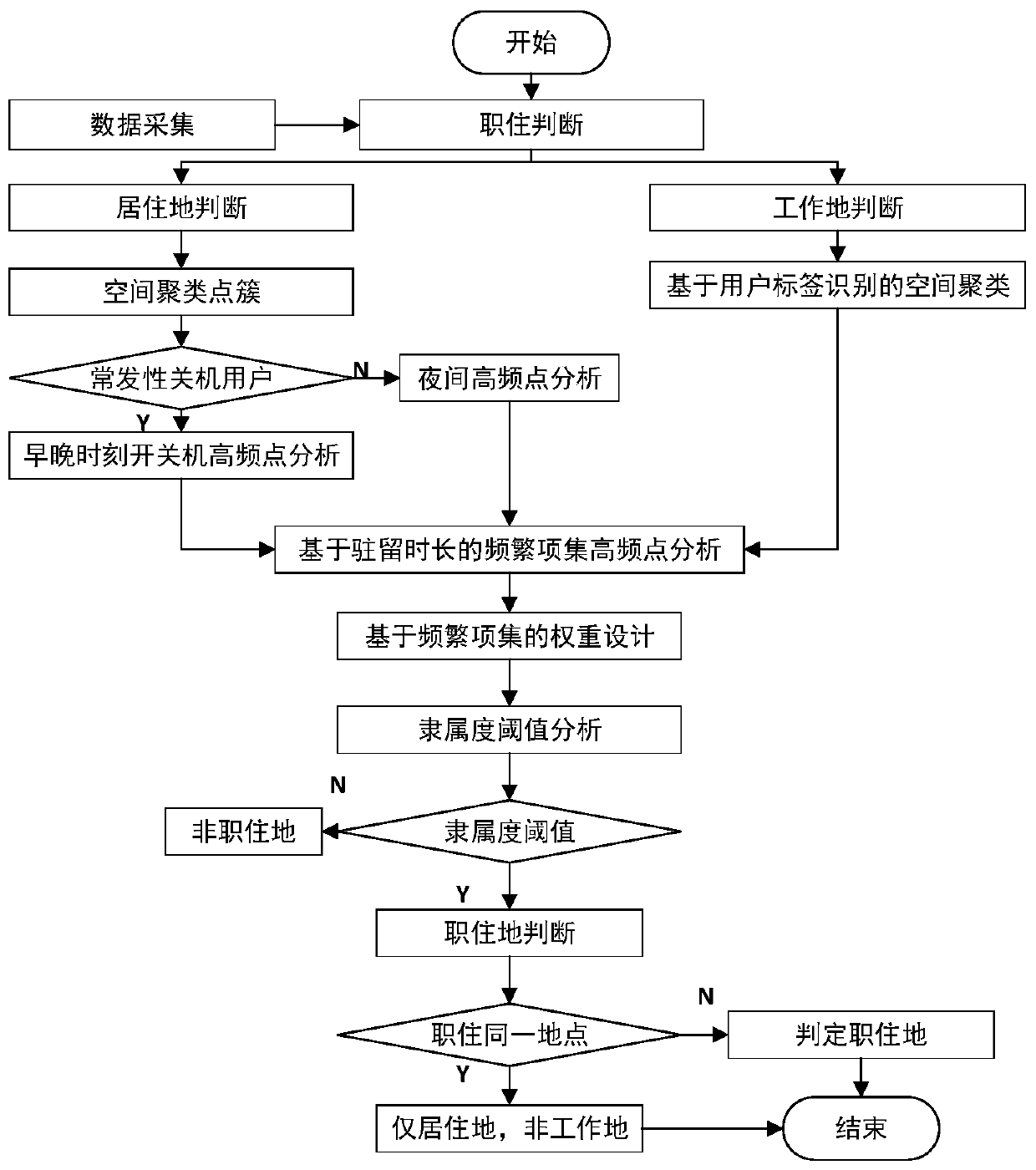
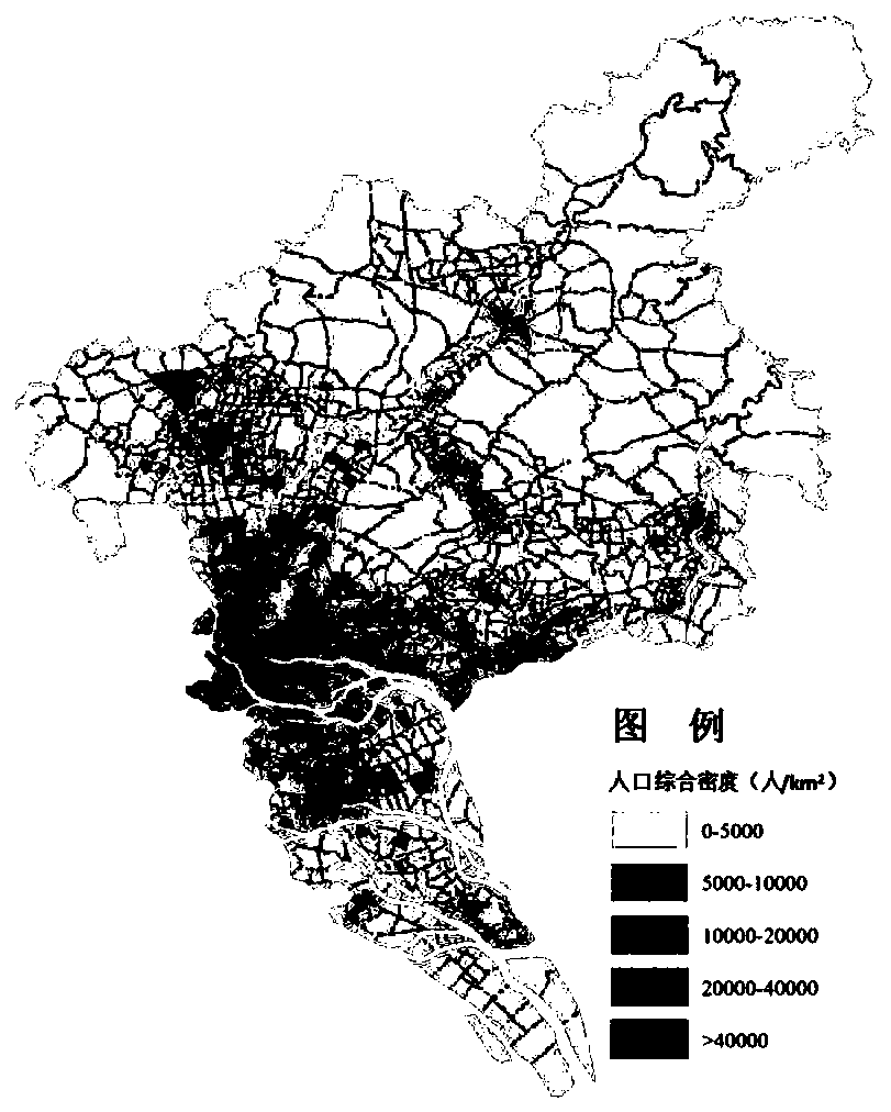
[0049] The urban vitality area is the most concentrated area of ​​political, economic, cultural and other public activities in a city. It is the main part of the urban public activity system. It is spatially different from other parts of the city. The central urban area is the most mature area in the current state of the city. It is mainly multi-functional and comprehensive. It gathers the main areas of urban production and services. It is a political and administrative c...


PUM


Abstract

The invention relates to a big data-based method for identifying boundaries of an urban active area and a central urban area. The method is based on information data, four indexes of dynamic and static combination are adopted for comprehensive analysis. The boundary of the urban active area and the central urban area identified based on a kernel density method; practicality of the method is provedby taking Guangzhou as an example, and mature boundaries of a central vitality area and a central urban area of Guangzhou are identified to be 93 square kilometers and 600 square kilometers respectively and are basically equivalent to those of an international first-class city, so that a more persuasive basis is provided for urban traffic development policy experience reference of different areas.

Description

technical field [0001] The invention belongs to the technical field of urban space identification research, and in particular relates to a method for identifying the boundaries of urban vitality areas and central urban areas based on information data. Background technique [0002] Urban spatial structure is the distribution and combination of urban elements within the spatial range, the spatial projection of urban economic structure and social structure, and the spatial form of urban social economic existence and development. Urban traffic development and management need to implement different policies in combination with regional differences. The identification of urban vitality areas and central urban boundaries can help differentiated policy regional control accuracy. For example, stricter parking management and traffic demand management policies are implemented in vitality areas. And implement more flexible transportation infrastructure construction outside the vitality ...

Claims


Application Information

Patent Timeline
IPC IPC(8): G06K9/32G06K9/62G06Q10/06G06Q50/26H04W4/021H04W8/18
CPCG06Q50/26G06Q10/06313H04W4/021H04W8/183G06V10/25G06F18/23
Inventor 马小毅宋程金安陈先龙陈嘉超丁晨滋李彩霞刘新杰艾冠韬霍佳萌徐良李磊
Owner 广州市交通规划研究院有限公司
Why Eureka
Try Eureka