Accurate positioning system and method for mining electric shovel

A precise positioning and precise positioning technology, which is applied in satellite radio beacon positioning system, radio wave measurement system, measuring device, etc., can solve the problem that the actual operation direction and running track cannot be effectively recorded, and cannot meet the actual precise positioning and running track of production Measurement and assessment requirements, the detection system cannot run on the electric shovel, etc., to achieve the effect of improving mining production effect, fast information acquisition, and fast performance mode

Pending Publication Date: 2019-12-10
ANSTEEL GRP MINING CO LTD
View PDF7 Cites 10 Cited by
  • Summary
  • Abstract
  • Description
  • Claims
  • Application Information

AI Technical Summary

Problems solved by technology

The position of the electric shovel carries the explosive material information. In the past, the electric shovel used GPS satellite positioning technology, and the general error was about 5-15 meters. However, the actual working distance of each shift in actual production and mining is generally about 20 meters. Usually, the electric shovel rotates left and right for loading. Car production requires forward and backward excavation of materials. The positioning points are like a mess. The working time of each shift is about 12 hours. Th

Method used


Image

  • Accurate positioning system and method for mining electric shovel
  • Accurate positioning system and method for mining electric shovel
  • Accurate positioning system and method for mining electric shovel

Examples


Example Embodiment

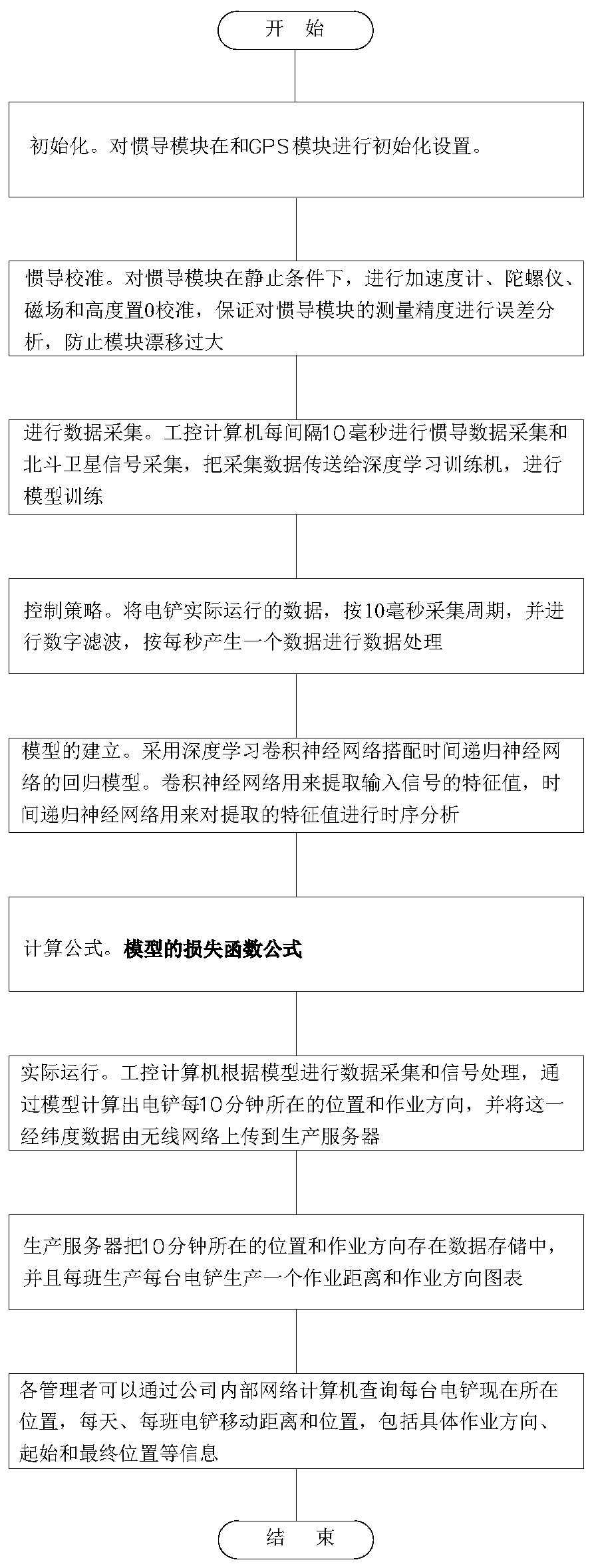
[0038] The technical content of the present invention will be further described in detail below in conjunction with the accompanying drawings.

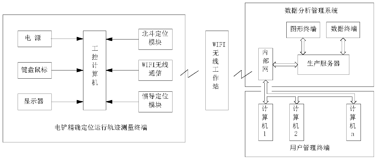
[0039] Such as figure 1 As shown, a precision positioning system for a mining electric shovel of the present invention is characterized in that it includes a precise positioning and running track measurement terminal of the electric shovel, a data analysis and management system, and a user management terminal.

[0040] The electric shovel precise positioning operation track measurement terminal includes an industrial control computer, a power supply module, a keyboard and mouse, a display module, a Beidou GPS positioning module, a WIFI communication module, and an inertial navigation positioning module. The power supply module, keyboard and mouse, display module, Both the Beidou GPS positioning module and the inertial navigation positioning module are electrically connected to the industrial control computer;

[0041] The data analysis manag...


PUM


Abstract

The invention provides an accurate positioning system and method for a mining electric shovel. The system and method are characterized in that: the system comprises an electric shovel accurate positioning moving track measuring terminal, a data analysis and management system and a user management terminal; the electric shovel accurate positioning moving track measuring terminal gets access to enterprise intranet through a WIFI wireless workstation, and is connected to the data analysis and management system and the user management terminal; through data acquisition of an inertial navigation positioning module and a Beidou GPS positioning module which are arranged on a forklift and combined computing, and through a deep learning computing method, swing of electric shovel loading is eliminated, an actual moving track is researched, a large amount of collected real-time data is continuously trained, the moving track is calculated and described, real-time accurate positioning of the electric shovel is achieved, and the operation direction and the moving distance are measured according to the shift; and the obtained real-time accurate data is transmitted to a background production management center for storage in real time, so that a reliable basis is provided for electric shovel operation assessment.

Description

Technical field [0001] The invention relates to a combined technology of positioning using inertial navigation and Beidou satellites, particularly a method for precise positioning and running track measurement of an open-pit mining electric shovel. Background technique [0002] The inertial navigation system is a navigation attitude calculation system composed of inertial sensors, accelerometers, gyroscopes, and magnetic sensors as basic measurement components. It integrates computer, control, mechanics, mathematics, optics, and electromechanical disciplines to integrate various disciplines. Linked together, constitute a modern technology with high-tech content. The inertial navigation system is based on the theoretical basis of the principle of inertia, not only does not rely on any information from the outside world, but also does not radiate energy to the outside world, no matter what kind of propagation medium space, and regardless of the change of climatic conditions, it onl...

Claims


Application Information

Patent Timeline
IPC IPC(8): G01C21/16G01C21/20G01S19/47
CPCG01C21/165G01C21/20G01S19/47
Inventor 孙亚鑫周仁杰王勐段喜涛韩得久孙健张威隋秋菊
Owner ANSTEEL GRP MINING CO LTD
Why Eureka
Try Eureka