Arterial highway viewing platform land scale planning method

A viewing platform and arterial technology, which is applied in the field of traffic engineering, can solve the problem of the scale and size of the viewing platform without the arterial highway, and achieve the effect of comfortable viewing effect.

Inactive Publication Date: 2019-12-20
HARBIN INST OF TECH
View PDF2 Cites 0 Cited by
  • Summary
  • Abstract
  • Description
  • Claims
  • Application Information

AI Technical Summary

Problems solved by technology

Most of the existing studies involve the design and construction form of the specific location of the viewing platform. 107419697A studies a new ty...

Method used


Image

  • Arterial highway viewing platform land scale planning method
  • Arterial highway viewing platform land scale planning method
  • Arterial highway viewing platform land scale planning method

Examples


specific Embodiment approach 1

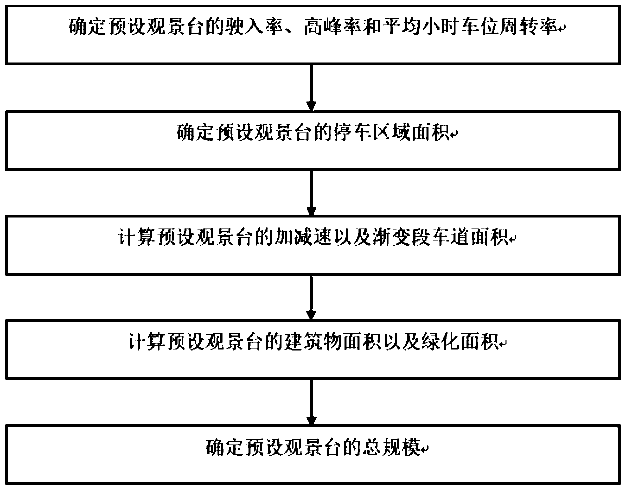
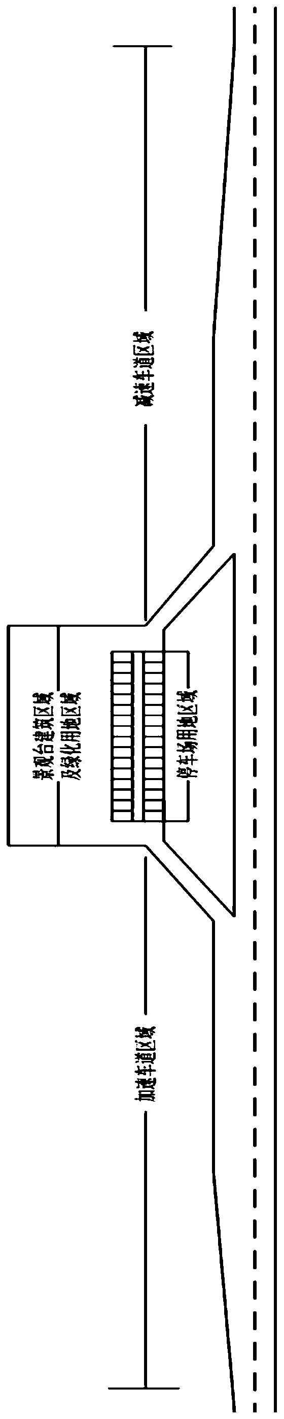
[0014] Specific implementation manner one: such as figure 1 As shown, the method for planning the land use of a trunk highway viewing platform in this embodiment includes the following steps:

[0015] Step 1. Investigate the traffic volume of the preset viewing platform area, and determine the entry rate, peak rate and average hourly parking turnover rate of the preset viewing platform based on the survey results;

[0016] In the first case, there is no corresponding viewing platform in the preset viewing platform area. At this time, the traffic volume survey is mainly based on the traffic volume on both sides of the same type of viewing platform located on the same level of trunk highway. The time survey is based on It is advisable to conduct a 1h traffic data survey at an interval of 15 minutes between 9 a.m. and 15 p.m. The corresponding entry rate, peak rate, and turnover rate are determined by analogy with the same type of observation deck survey data; in the second case, The ...

specific Embodiment approach 2

[0021] Specific embodiment two: This embodiment is different from specific embodiment one in that: in the first step, the traffic volume of the preset viewing platform area is investigated, and the entrance rate of the preset viewing platform is determined according to the survey results. The specific process is:

[0022] The scenic area along the arterial highway shall be the object of observation deck layout;

[0023] If there is no viewing platform in the area of ​​a preset viewing platform, the entrance rate of the preset viewing platform is:

[0024] P1 (National Trunk Line) = 0.0038×DSL (1)

[0025] P2 (provincial highway, tourism and leisure area) = 0.0026×DSL (2)

[0026] P3 (County Road) = 0.0018×DSL (3)

[0027] Among them: if the preset viewing platform is located on the national highway, the entry rate of the preset viewing platform is P1 (%); if the preset viewing platform is located on the provincial highway (or tourist and leisure area), then The entry rate of the defaul...

specific Embodiment approach 3

[0028] Specific embodiment three: This embodiment is different from specific embodiment one in that: in the first step, the traffic volume of the preset viewing platform area is investigated, and the entry rate of the preset viewing platform is determined according to the survey results. The specific process is:

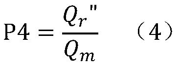
[0029] If an observation deck has been installed in the area of ​​a preset observation deck, but the existing observation deck is running poorly and the facilities are not reasonable enough, so the observation deck needs to be reset, then the entrance rate of the observation deck is preset for:

[0030]

[0031] Where: P4 represents the vehicle entry rate of the preset viewing platform; Q r "Represents the daily traffic volume entering into the observation deck, the unit is standard vehicle / day, Q m Represents the daily traffic volume of the arterial road in the section where the viewing platform is installed, and the unit is a standard vehicle / day.


PUM


Abstract

The invention discloses an arterial highway viewing platform land scale planning method, and belongs to the field of traffic engineering. The method solves the problem of lack of research on the scaleof the viewing platform of the arterial highway at present. The method comprises: using the beautiful scenery area along the arterial highway as a viewing platform layout object; investigating the entry rate, the peak rate and the turnover rate of the preset viewing platform to determine the scale of the parking area; calculating the corresponding acceleration and deceleration lane scale according to the highway design grade; and finally, determining a preset viewing platform building area and a greening area according to the occupied area of the common trunk road service facility, so as to determine the preset landscape platform scale according to the size of the landscape platform, so that land resources can be effectively utilized, self-driving tourists can experience a more comfortable viewing effect. A research method for the scale of the landscape platform of the arterial road is provided, and the defects in the prior art are overcome. The method can be applied to scale planningof the arterial highway viewing platform.

Description

Technical field [0001] The invention belongs to the field of traffic engineering, and in particular relates to a method for planning the land use of a trunk highway viewing platform. Background technique [0002] With the improvement of our people's living standards and the increase in the number of motor vehicles, self-driving tours have developed rapidly. People are not only satisfied with tourist attractions in tourist attractions, but also hope to feel the nature and enjoy the fun of nature during the driving journey. The society's requirements for tourist roads are not just pure traffic functions, but new requirements have been added, that is, driving pleasure and enjoyment to tourists during highway driving. Therefore, the construction of tourist roads in the new era has higher goals and requirements, that is, from the traditional "tourist road" that emphasizes transportation functions to "road tourism" that emphasizes journey enjoyment. [0003] The existing domestic arter...

Claims


Application Information

Patent Timeline
IPC IPC(8): G06Q10/06G06Q50/08G06Q50/26
CPCG06Q10/06313G06Q10/06315G06Q50/08G06Q50/26
Inventor 陈剑王刚洛玉乐刘锡泽杜泽华毛伟曹舰镨鲍兴浩马涛
Owner HARBIN INST OF TECH
Why Eureka
Try Eureka