Eureka AIR delivers breakthrough ideas for toughest innovation challenges, trusted by R&D personnel around the world.

Offshore basin sea lake environment identification method and system

A technology for environmental recognition, basin applications in character and pattern recognition, special data processing applications, instruments, etc.

Active Publication Date: 2020-01-03
BEIJING NORMAL UNIVERSITY
View PDF4 Cites 6 Cited by
  • Summary
  • Abstract
  • Description
  • Claims
  • Application Information

AI Technical Summary

Problems solved by technology

[0004] Based on this, it is necessary to provide a sea-lake environment identification method and system in offshore basins to solve the uncertainties and misunderstandings in the existing single analysis method, improve the accuracy of identification, and provide a unified system for the effective identification of the sedimentary environment in offshore basins. standard

Method used


Image

  • Offshore basin sea lake environment identification method and system
  • Offshore basin sea lake environment identification method and system
  • Offshore basin sea lake environment identification method and system

Examples


Embodiment 1

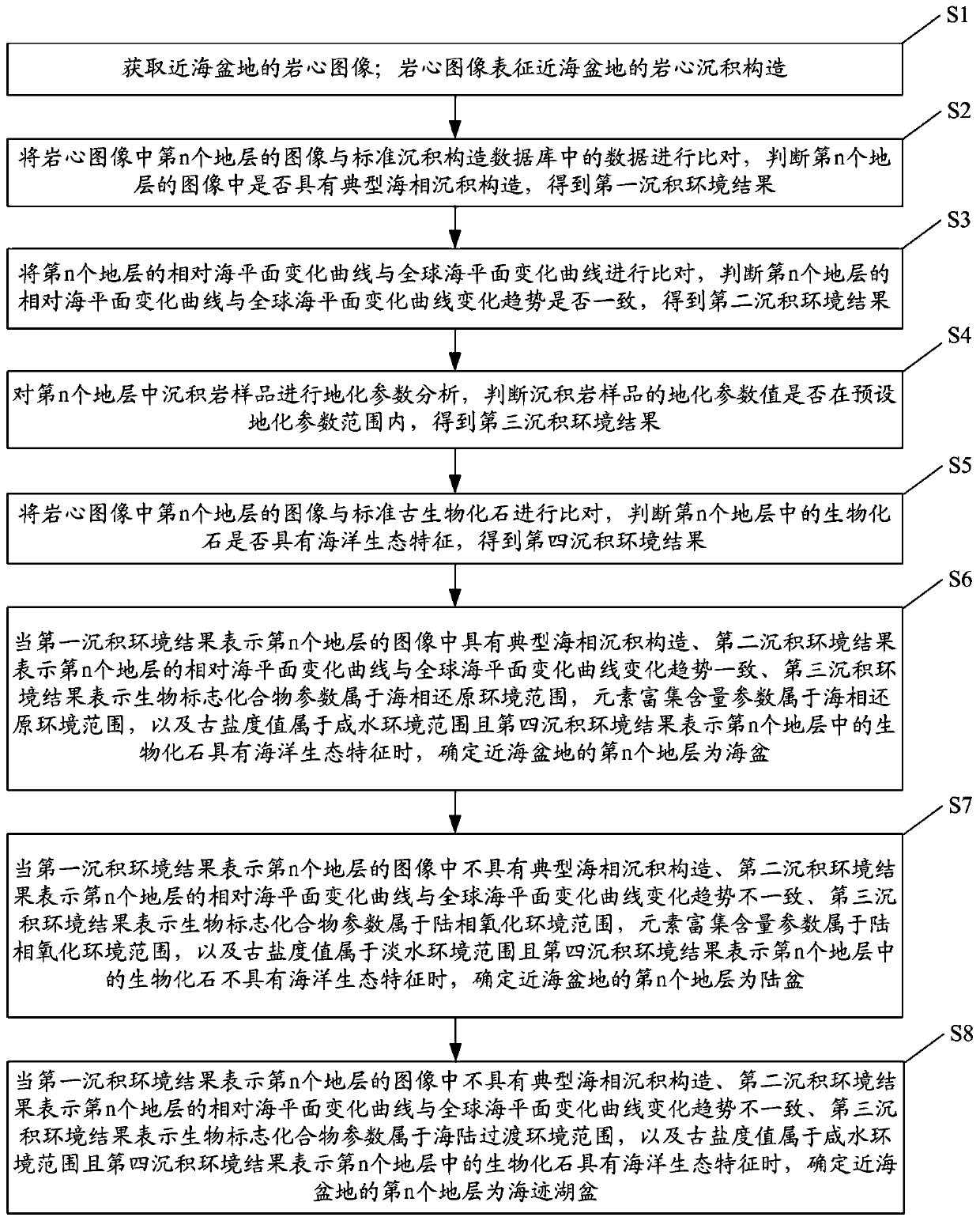
[0072] figure 1 It is a flow chart of a method for identifying sea and lake environments in offshore basins according to Embodiment 1 of the present invention.

[0073] see figure 1 , the offshore basin sea-lake environment identification method of the embodiment, comprising:

[0074] Step S1: Obtain the core image of the offshore basin; the core image represents the core sedimentary structure of the offshore basin.

[0075] Step S2: Compare the image of the nth stratum in the core image with the data in the standard sedimentary structure database, judge whether the image of the nth stratum has a typical marine sedimentary structure, and obtain the first sedimentary environment result.

[0076] Typical marine sedimentary structures are herringbone cross-bed structure, tidal clay layer structure, beach cross-bed structure, storm cross-bed structure or foamy sand structure.

[0077] Step S3: Compare the relative sea level change curve of the nth layer with the global sea leve...

Embodiment 2

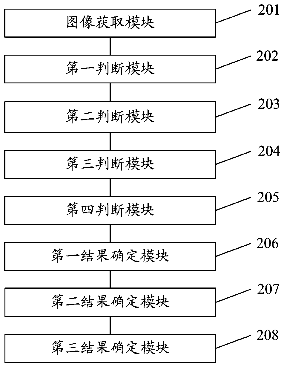
[0105] The present invention also provides a sea and lake environment recognition system for offshore basins, figure 2 It is a structural schematic diagram of an offshore basin sea-lake environment recognition system according to Embodiment 2 of the present invention. see figure 2 , the offshore basin sea-lake environment recognition system of this embodiment includes:

[0106] The image acquisition module 201 is configured to acquire a core image of an offshore basin; the core image represents the core sedimentary structure of the offshore basin.

[0107] The first judging module 202 is used to compare the image of the nth stratum in the core image with the data in the standard sedimentary structure database, judge whether there is a typical marine sedimentary structure in the image of the nth stratum, and obtain the first sedimentary structure Environmental results; typical marine sedimentary structures are herringbone cross-bed structure, tidal clay layer structure, bea...

Embodiment 3

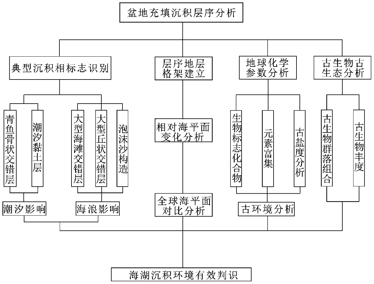
[0133] This embodiment provides a more specific implementation of the method for identifying sea and lake environments in offshore basins. The main ideas are as follows: firstly, comprehensively use core and drilling data to study the sedimentary sequence of basin filling, compare and identify typical sedimentary structures of different sedimentary systems; Finally, use geochemical parameters, element enrichment law, paleo-salinity, paleo-ecology, etc. to make auxiliary judgments. The formation is based on the identification of the facies markers of the sedimentary system of the sea-lake basin, assisted by sea level changes and analytical parameters, to effectively identify the sea-lake sedimentary environment, clarify key indicators for sea-lake sedimentary environment identification, and establish a comprehensive evaluation system.

[0134] Step 1: Carry out basin sequence stratigraphy research, compare the basin filling sedimentary sequence with the classic sequence stratig...


PUM


Abstract

The invention discloses an offshore basin sea lake environment identification method and system. The method comprises the following steps: judging whether an image of an nth stratum in a rock core image has a typical marine facies deposition structure or not to obtain a first deposition environment result; judging whether the change trend of the relative sea level change curve of the nth stratum is consistent with that of the global sea level change curve or not to obtain a second sedimentary environment result; judging whether the geochemical parameter value of the sedimentary rock sample iswithin a preset geochemical parameter range or not to obtain a third sedimentary environment result; judging whether the biological fossil in the nth stratum has marine ecological characteristics or not to obtain a fourth sedimentary environment result; and integrating the first sedimentary environment result, the second sedimentary environment result, the third sedimentary environment result andthe fourth sedimentary environment result to determine an offshore basin sea lake environment recognition result which is a sea basin, a land basin or a sea trace lake basin. The offshore basin sea lake environment is comprehensively recognized, and the recognition accuracy can be improved.

Description

technical field [0001] The invention relates to the technical field of sea and lake environment recognition, in particular to a method and system for sea and lake environment recognition in offshore basins. Background technique [0002] Offshore basins are rich in oil and gas resources, but due to the lack of obvious marine sedimentary features in offshore basins, these basins have always been regarded as continental oil and gas basins. This point of view, in the early stages of petroleum geological research and petroleum exploration, undoubtedly played a great role in promoting oil and gas exploration. With the deepening of exploration and development and the development of science and technology, a large number of evidences of marine ecology and transgression have been found in these basins, especially in the layers where the source rocks are developed. The abundant dinoflagellates and planktonic foraminifera often correspond to the rising period of the global sea level. ...

Claims


Application Information

Patent Timeline
Patent Type & Authority Applications(China)
IPC IPC(8): G06F16/583G06K9/62
CPCG06F16/583G06V10/751
Inventor 张金亮孙中强李阳李娜
Owner BEIJING NORMAL UNIVERSITY
Why Eureka
Eureka Blog
Learn More