Spatial data synchronization method, terminal and computer readable storage medium

A spatial data and computer technology, applied in structured data retrieval, geographic information database, special data processing applications, etc., can solve the problems of uncontrolled synchronization process, high resource consumption, low analytical performance, etc. Satisfy the effect of cache and large cache space

Active Publication Date: 2020-01-10
INSPUR SOFTWARE CO LTD
View PDF5 Cites 3 Cited by
  • Summary
  • Abstract
  • Description
  • Claims
  • Application Information

AI Technical Summary

Problems solved by technology

Geodatabase Replication technology (Geodatabase Replication) is based on versioned data, supports complete data models such as topology and network, and can realize data replication and synchronization between different types of databases; but Geodatabase Replication technology also exists such as resources Defects such as excessive consumption, the need to connect to the network environment, and the granularity of synchronized database objects cannot be freely controlled
[0004] The Chinese patent with the application number 201110318256.3 published on June 20, 2012 discloses an XML-based incremental synchronization update method for spatial data, which is used to establish a two-way synchronization mechanism for spatial data and realize the approximate consistency maintenance of multiple copies of data , to solve the problems that the common data synchronization method does not support the offline environment, does not support heterogeneous databases, the granularity of the synchronization object, and the synchronization process cannot be freely controlled.
[0005] The above technical solution is based on XML. Due to the low parsing performance of XML itself, there will be performance problems when the amount of data is large, especially in the background of big data and the real-time requirements of many current businesses.

Method used


Image

  • Spatial data synchronization method, terminal and computer readable storage medium

Examples


Embodiment 1

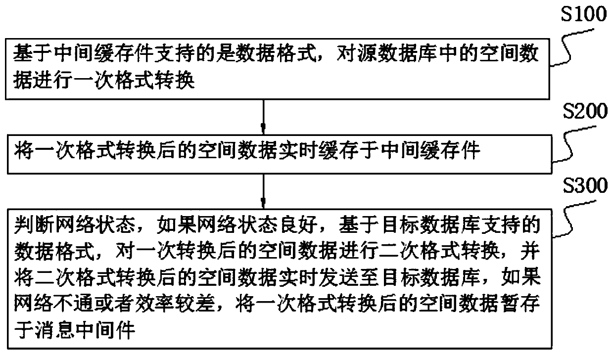
[0033] A spatial data synchronization method of the present invention is used to synchronize the spatial data in the source database to the target database, as shown in the attached figure 1 As shown, the synchronization method is:

[0034] S100. Based on the data format supported by the intermediate cache, perform a format conversion on the spatial data in the source database;

[0035] S200. Caching the spatial data after a format conversion in an intermediate cache in real time;

[0036] S300. Determine the network status. If the network status is good, perform secondary format conversion on the spatial data after primary conversion based on the data format supported by the target database, and send the spatial data after secondary format conversion to the target database in real time. If the network If it is unreasonable or inefficient, the spatial data after a format conversion is temporarily stored in the message middleware.

[0037] In this embodiment, the intermediate...

Embodiment 2

[0046] A terminal of the present invention includes a processor, an input device, an output device, and a memory, the processor, the input device, the output device, and the memory are connected to each other, and the memory is used to store a computer program, the above-mentioned computer program includes program instructions, and the above-mentioned processor is It is configured to invoke the above program instructions to execute a spatial data synchronization method disclosed in Embodiment 1.

Embodiment 3

[0048] A computer-readable storage medium of the present invention, the above-mentioned computer-readable storage medium stores a computer program, the above-mentioned computer program includes program instructions, and when the program instructions are executed by a processor, the above-mentioned processor executes a kind of spatial data disclosed in Embodiment 1 synchronous method.


PUM


Abstract

The invention discloses a spatial data synchronization method, a terminal and a computer readable storage medium, belongs to spatial data synchronous transmission, and aims to solve the technical problem of how to provide a spatial data synchronization method which is high in performance and capable of realizing synchronization in case of network disconnection. The synchronization method comprisesthe following steps: performing primary format conversion on spatial data in a source database based on a data format supported by an intermediate cache; caching the spatial data subjected to the primary format conversion in an intermediate cache in real time; and if the network state is good, sending the spatial data subjected to secondary format conversion to the target database in real time based on the data format supported by the target database, and if the network is blocked or the efficiency is poor, temporarily storing the spatial data subjected to primary format conversion in messagemiddleware. The terminal comprises a processor and a memory. The processor is configured to call a program instruction to execute the synchronization method. A computer program is stored in the storage medium, and the processor executes the method when program instructions are executed by the processor.

Description

technical field [0001] The invention relates to the field of synchronous transmission of spatial data, in particular to a method for synchronizing spatial data, a terminal and a computer-readable storage medium. Background technique [0002] Now GIS has been widely used in many industries. GIS information is mostly stored in the form of spatial data structure, and standard SQL cannot read and write spatial data in the database. If the spatial data in one database is synchronized to another homogeneous or heterogeneous database, traditional ETL tools cannot be used. [0003] ESRI, a well-known American GIS software manufacturer, provides a commercial solution based on Geodatabase replication technology, which can realize data replication and synchronization between two or more Geodatabases. Geodatabase Replication technology (Geodatabase Replication) is based on versioned data, supports complete data models such as topology and network, and can realize data replication and s...

Claims


Application Information

Patent Timeline
Patent Type & Authority Applications(China)
IPC IPC(8): G06F16/27G06F16/29
CPCG06F16/275G06F16/29Y02D10/00
Inventor 李朝铭曹景亮
Owner INSPUR SOFTWARE CO LTD
Why Eureka
Try Eureka