A kind of water conservancy and hydropower engineering surveying and mapping device and its surveying and mapping method

A technology for water conservancy and hydropower, surveying and mapping devices, which is applied to surveying devices, surveying and mapping and navigation, surveying instruments, etc., can solve the problems of inconvenient installation of the total station, unfavorable adaptation of the surveying and mapping device, and inability to adjust the total station, and achieves increased convenience. It is easy to adjust the height position, and it is easy to install and remove.

Active Publication Date: 2020-12-29
温州江航建设有限公司
View PDF16 Cites 1 Cited by
  • Summary
  • Abstract
  • Description
  • Claims
  • Application Information

AI Technical Summary

Problems solved by technology

[0006] The purpose of the present invention is to provide a water conservancy and hydropower engineering surveying and mapping device and its surveying and mapping method, to solve the current water conservancy and hydropower engineering surveying and mapping device on the market proposed by the above-mentioned background technology, the installation work of the total station is not convenient enough in the process of using At the same time, it is impossible to effectively adjust the height of the total station in the follow-up, which is not conducive to the problem that the water conservancy and hydropower engineering surveying and mapping device can adapt to people of different heights

Method used


Image

  • A kind of water conservancy and hydropower engineering surveying and mapping device and its surveying and mapping method
  • A kind of water conservancy and hydropower engineering surveying and mapping device and its surveying and mapping method
  • A kind of water conservancy and hydropower engineering surveying and mapping device and its surveying and mapping method

Examples


Embodiment Construction

[0037] The following will clearly and completely describe the technical solutions in the embodiments of the present invention with reference to the accompanying drawings in the embodiments of the present invention. Obviously, the described embodiments are only some, not all, embodiments of the present invention. Based on the embodiments of the present invention, all other embodiments obtained by persons of ordinary skill in the art without making creative efforts belong to the protection scope of the present invention.

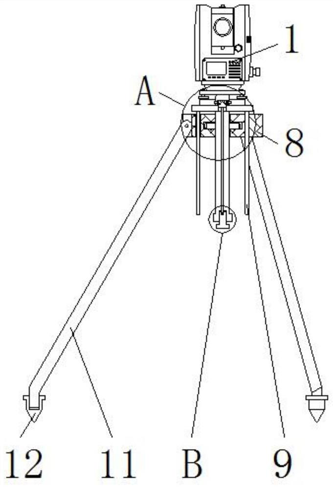
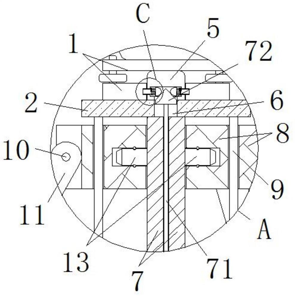
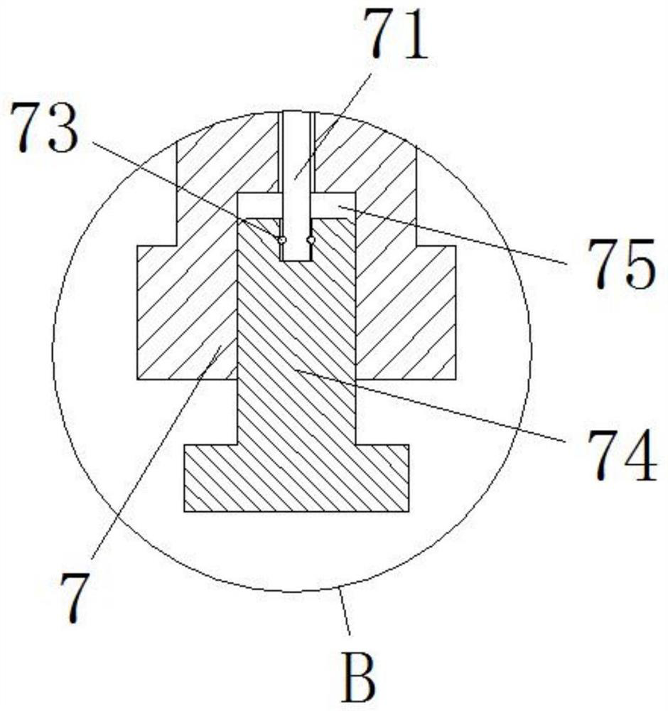
[0038] see Figure 1-7 , the present invention provides a technical solution: a water conservancy and hydropower engineering surveying and mapping device, comprising a total station main body 1, a first rotating shaft 10, a support frame 11, a driving gear 14 and a second rotating shaft 15, and the total station main body 1 is installed on a flat panel 2, and the center of the bottom surface of the total station main body 1 is provided with a connecting groove...


PUM


Abstract

The invention discloses a water resource and hydropower surveying and mapping device. The water resource and hydropower surveying and mapping device comprises a total station main body, a first rotating shaft, a supporting frame, a driving gear and a second rotating shaft. The total station main body is installed on the bottom face of a flat plate, and a connecting groove is formed in the center of the bottom face of the total station main body. A limiting hole is formed in the inner wall of the bottom end of the total station main body and further connected with the connecting groove. The connecting groove is connected with a fixed plate, and the fixed plate is fixedly installed on the top face of the flat plate. A limiting groove is formed in the flat plate, and a supporting shaft is fixedly installed on the bottom face of the flat plate. According to the water resource and hydropower surveying and mapping device and a surveying and mapping method thereof, the total station main bodyand the fixed plate are assembled in a clamped mode through the connecting groove, and the total station main body can be initially positioned conveniently; and meanwhile the overlook map of the fixed plate is a square, tilting of the total station main body can be effectively prevented, a limiting shaft and the limiting hole are connected in a clamped mode for fixation subsequently, and installation work can be facilitated.

Description

technical field [0001] The invention relates to the technical field of water conservancy and hydropower engineering, in particular to a water conservancy and hydropower engineering surveying and mapping device and a surveying and mapping method thereof. Background technique [0002] Water conservancy and hydropower projects are mainly for the construction of water conservancy and hydropower projects. Relevant equipment and tools are used to survey, plan, design, and construct water conservancy and hydropower projects and related projects. When surveying and mapping water conservancy and hydropower projects, water conservancy Hydropower engineering surveying and mapping device, but the existing water conservancy and hydropower engineering surveying and mapping device still has the following problems: [0003] 1. In the process of using, the assembly between the total station and the tripod is not convenient enough. At the same time, after the total station is assembled, the t...

Claims


Application Information

Patent Timeline
Patent Type & Authority Patents(China)
IPC IPC(8): G01C15/00
CPCF16M11/041F16M11/046F16M11/18F16M11/38G01C15/00
Inventor 曾青松
Owner 温州江航建设有限公司
Why Eureka
Try Eureka