Low-altitude remote sensing and ground sensing dual-sampling simulation system

A simulation system and double-sampling technology, applied in design optimization/simulation, advanced technology, electrical components, etc., can solve problems such as missing ground nodes, wasting precious time of UAVs, and unable to simultaneously collect double-acquisition in an orderly and efficient manner. Achieve the effect of saving research time and improving research efficiency

Active Publication Date: 2020-01-17
广东友元国土信息工程有限公司 +1
View PDF3 Cites 2 Cited by
  • Summary
  • Abstract
  • Description
  • Claims
  • Application Information

AI Technical Summary

Problems solved by technology

Now the UAV-WSN system can only use the DJI Simulator to replace the flight simulation for the simulation before the sampling flight. It can only simulate the flight situation of the UAV according to the route, and it cannot simulate the simultaneous acquisition process of the two systems.
[0004]If the dual information collection of UAV-WSN in the air is directly carried out without simulation planning before the flight, it will not be able to collect the two low-altitude remote sensing + wireless sensor networks simultaneously in an orderly and efficient manner. Systematic dual collection of information
Going directly to the actual air flight without simulation planning will not only waste the precious time of UAV aerial work (the battery of a general UAV can only work in the air for 30-60 minutes at a time), what is more, the UAV in the air Mobile aggregation nodes, in the face of tens of thousands of wireless sensor nodes that are disorderly on the ground, are likely to miss some or even piles and patches of ground nodes

Method used


Image

  • Low-altitude remote sensing and ground sensing dual-sampling simulation system
  • Low-altitude remote sensing and ground sensing dual-sampling simulation system
  • Low-altitude remote sensing and ground sensing dual-sampling simulation system

Examples


Embodiment

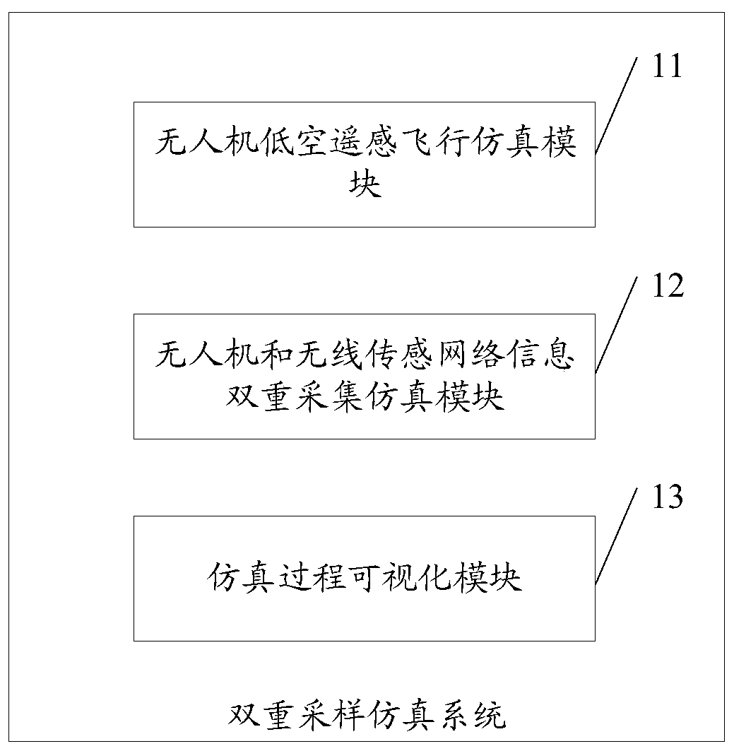
[0044] see figure 1 , figure 1 It is a schematic diagram of the structure and composition of the double-sampling simulation system for low-altitude remote sensing and ground sensing in the embodiment of the present invention.

[0045] Such as figure 1 Shown, a double sampling simulation system of low-altitude remote sensing and ground sensing, said system includes:

[0046]UAV low-altitude remote sensing flight simulation module 11: used to simulate the flight data of the UAV during flight, the flight data includes: flight route data, accumulated flight time data, remaining flight time data and remaining power data;

[0047] In the specific implementation process of the present invention, the low-altitude remote sensing flight simulation module 11 of the UAV includes: a flight route planning unit: used to use the DJI Ground Station Pro system to carry out route simulation automatic planning processing based on the principle of aerial photogrammetry, and obtain flight Route ...


PUM


Abstract

The invention discloses a low-altitude remote sensing and ground sensing dual-sampling simulation system, and the system comprises: an unmanned plane low-altitude remote sensing flight simulation module which is used for simulating the flight data of an unmanned plane in a flight process; a unmanned aerial vehicle and wireless sensor network information dual-acquisition simulation module which isused for low-altitude remote sensing data acquisition simulation of the unmanned aerial vehicle and data ground convergence and air transmission simulation of wireless sensor network data acquisition;and a simulation process visualization module which is used for carrying out visualization processing on the flight route data of the simulation unmanned aerial vehicle and the data transmission of the wireless sensor network, and carrying out visualization processing on the flight sampling process of the simulation unmanned aerial vehicle on the flight route data. In the embodiment of the invention, low-altitude remote sensing sampling and ground sensing sampling three-dimensional transmission can be simulated at the same time, the energy consumed by each ground node in data transmission andthe data volume acquired by the unmanned aerial vehicle are calculated in a simulation mode, and the research time for energy consumption optimization and data optimization is greatly saved.

Description

technical field [0001] The invention relates to the technical field of unmanned aerial vehicle flight simulation, in particular to a double-sampling simulation system for low-altitude remote sensing and ground sensing. Background technique [0002] The emulator imitates the operation of hardware devices such as single-chip microcomputers in the computer through software, solves the problem that hardware devices can only be repeatedly run and observes the results with the naked eye, and realizes various functions such as single-step operation, breakpoints, and data tracking. The key parameters in the process greatly shorten the cycle and difficulty of software and hardware development, and save a lot of manpower, material resources and practice. [0003] As a widely used monitoring technology, both WSN and UAV have simulators. The WSN emulator can simulate various routing protocols, analyze the transmission process of each data packet, and evaluate the quality of the entire ...

Claims


Application Information

Patent Timeline
Patent Type & Authority Applications(China)
IPC IPC(8): G06F30/20H04W24/06
CPCH04W24/06Y02D30/70
Inventor 胡月明张飞扬陈联诚
Owner 广东友元国土信息工程有限公司
Why Eureka
Try Eureka