

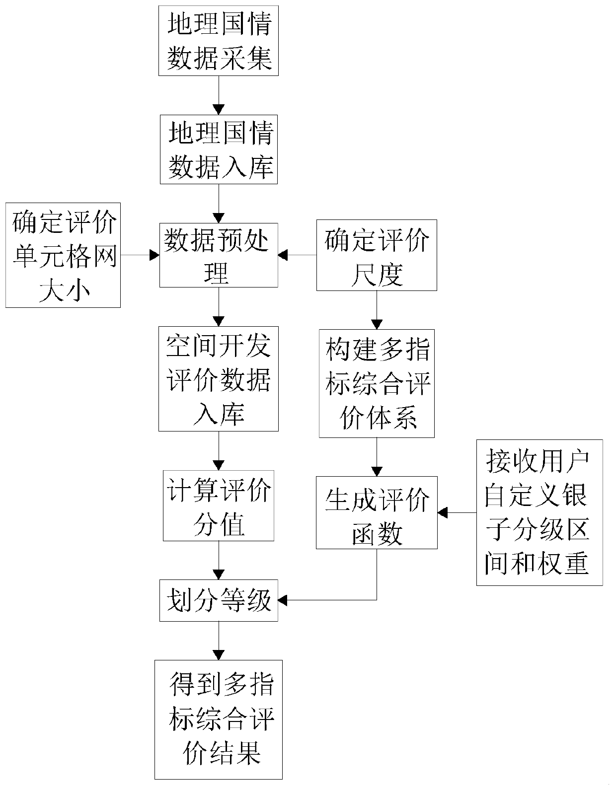
Multi-scale spatial analysis and evaluation method and system based on geographical national conditions
A technology of spatial analysis and evaluation methods, applied in geographic information databases, data processing applications, special data processing applications, etc., can solve the problems of single evaluation scale, integrity, poor semantic consistency and timing, and different data sources. The effect of reducing the loss of evaluation accuracy, fine-grained content division, and rapid warehousing and updating
- Summary
- Abstract
- Description
- Claims
- Application Information
AI Technical Summary
Problems solved by technology
Method used
Image

Examples
Embodiment 1
[0042] The evaluation method of ecological environment indicators is described below:
[0043] This dimension evaluation utilizes geographical national conditions and land cover data. The sub-indicators and weights of the ecological environment index are shown in the table below:
[0044]
[0045] Ecological environment index = habitat quality index × 0.25 + ecological protection index × 0.20 + ecological structure index × 0.30 + (100-land stress index) × 0.25. The value range of the ecological environment index is 0-100.
[0046] Regional Habitat Quality Index, used to describe the suitability of regional habitat quality. Regional habitat quality index = 100 × (0.35 × forest land + 0.21 × grassland + 0.28 × water wetland + 0.11 × cultivated land + 0.04 × construction land + 0.01 × unused land) / regional area. The weights of each ecological land type in the Habitat Quality Index are shown in the table below:
[0047]
[0048] See the table below for the indicators and...
Embodiment 2
[0056] The evaluation method of urban construction indicators is described below:
[0057] (1) The formula for calculating traffic network density is as follows:
[0058]
[0059] ρ i =L i / S
[0060] T represents the traffic network density, M represents the technical level of the highway (divided into: high-speed, first-level, second-level, third-level, fourth-level, etc.), δ i Indicates the weight of roads of each grade in the region, as shown in the table below, ρ i Indicates the density of a certain grade of road in the area, L i Indicates the length of a road of a certain level in the area, and S indicates the area of the area.
[0061] Highway Technical Grade Weights high speed 0.125*number of lanes level one 0.092*number of lanes Secondary 0.15 Level three 0.06 Level 4 0.01 substandard 0.01
[0062] After the traffic network density is obtained, normalization processing is carried out, and the geometric i...
PUM
 Abstract
Description
Claims
Application Information