Method of Fusion of Binary Classification Semantic Segmentation Map into Multi-Classification Semantic Map Based on High-resolution Remote Sensing Image

A remote sensing image and semantic segmentation technology, which is applied in the directions of instruments, calculations, character and pattern recognition, etc., to achieve the effect of improving the overall classification accuracy

Active Publication Date: 2022-05-03
UNIV OF ELECTRONICS SCI & TECH OF CHINA
View PDF8 Cites 0 Cited by
  • Summary
  • Abstract
  • Description
  • Claims
  • Application Information

AI Technical Summary

Problems solved by technology

In the early days, it mainly relied on interpretation professionals for manual interpretation, which required a lot of manpower and material resources. At present, the traditional method is mainly used to directly extract ground object information directly according to the texture characteristics and multi-dimensional information of the image.

Method used


Image

  • Method of Fusion of Binary Classification Semantic Segmentation Map into Multi-Classification Semantic Map Based on High-resolution Remote Sensing Image
  • Method of Fusion of Binary Classification Semantic Segmentation Map into Multi-Classification Semantic Map Based on High-resolution Remote Sensing Image
  • Method of Fusion of Binary Classification Semantic Segmentation Map into Multi-Classification Semantic Map Based on High-resolution Remote Sensing Image

Examples


Embodiment Construction

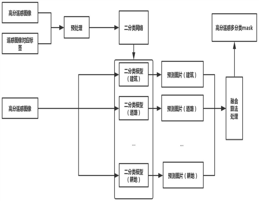
[0027] The invention includes several steps of image preprocessing, training multiple binary classification models, multiple binary classification predictions for a picture, calculating final classification discrimination matrix and classifying individual pixel points one by one.

[0028] Step 1. Image data preprocessing (assuming that the multi-category category is N categories)

[0029] 1-1 Firstly, the high-score remote sensing images and their corresponding labels are randomly cropped into pairs of small images with a size of 256*256.

[0030] 1-2 Then process the small label map into N two-category label maps, 0 in each label map represents the non-kth class, and 1 represents the k-th class (where k ranges from 0 to N).

[0031] 1-3 For the new original image and the corresponding N groups of label images, perform operations such as mirror flip, rotation, and Gaussian white noise in pairs to achieve data expansion.

[0032] Step 2. Train multiple binary classification ne...


PUM


Abstract

The invention provides a method for fusing binary classification semantic segmentation maps into multi-classification semantic maps based on high-resolution remote sensing images. The image data set is sent to the binary classification semantic segmentation network to train binary classification model groups, and the confidence degree of each binary classification model is calculated. ; Input the high-resolution remote sensing image to be predicted into the binary classification model group, and obtain the binary classification results output by each binary classification model and the initial prediction probability matrix; multiply the confidence of the binary classification model and the corresponding initial prediction probability matrix to The final discriminant probability matrix of the high-resolution remote sensing image to be predicted in the binary classification model; when classifying the pixels according to the binary classification results, for the pixel points with classification conflicts, the final discriminant probability of the pixel points in the binary classification model group The category with the largest probability value corresponding to the position of the matrix is ​​used as the classification category of the current pixel point. The invention can effectively improve the overall classification accuracy and IoU and kappa coefficient indexes of the final composite classification map.

Description

technical field [0001] The invention relates to computer image processing and high-resolution No. 2 satellite remote sensing image classification technology, in particular to a technology for fusing binary classification semantic segmentation prediction maps generated by deep learning semantic segmentation into high-resolution remote sensing images into multi-class semantic maps. Background technique [0002] High-resolution remote sensing image interpretation is widely used in land classification, land survey, regional investigation, ground feature change detection and other fields. In the early days, it mainly relied on interpretation professionals for manual interpretation, which required a lot of manpower and material resources. At present, the traditional method is mainly used to directly extract ground feature information directly according to the texture features and multi-dimensional information of the image. [0003] For example, the normalized difference vegetation...

Claims


Application Information

Patent Timeline
Patent Type & Authority Patents(China)
IPC IPC(8): G06V10/764G06V10/774G06K9/62
CPCG06F18/214G06F18/2415
Inventor 解梅彭清付威福王裕贺凯
Owner UNIV OF ELECTRONICS SCI & TECH OF CHINA
Why Eureka
Try Eureka