Map model construction method and map model construction system based on coordinate transformation
What is Al technical title?
Al technical title is built by PatSnap Al team. It summarizes the technical point description of the patent document.
A map model and coordinate transformation technology, applied in theodolites, road network navigators, etc., to solve problems such as inaccurate positioning
Active Publication Date: 2020-02-21
GUANGDONG POWER GRID CO LTD +1
View PDF9 Cites 5 Cited by
Summary
Abstract
Description
Claims
Application Information
AI Technical Summary
This helps you quickly interpret patents by identifying the three key elements:
Problems solved by technology
Method used
Benefits of technology
Problems solved by technology
[0003] In order to overcome the defect of inaccurate positioning of the real scene map used in the map system described in the prior art, the present invention
Method used
Image
Click on the blue label to locate the original text in one second.
Reading with bidirectional positioning of images and text.
Examples
Embodiment 1
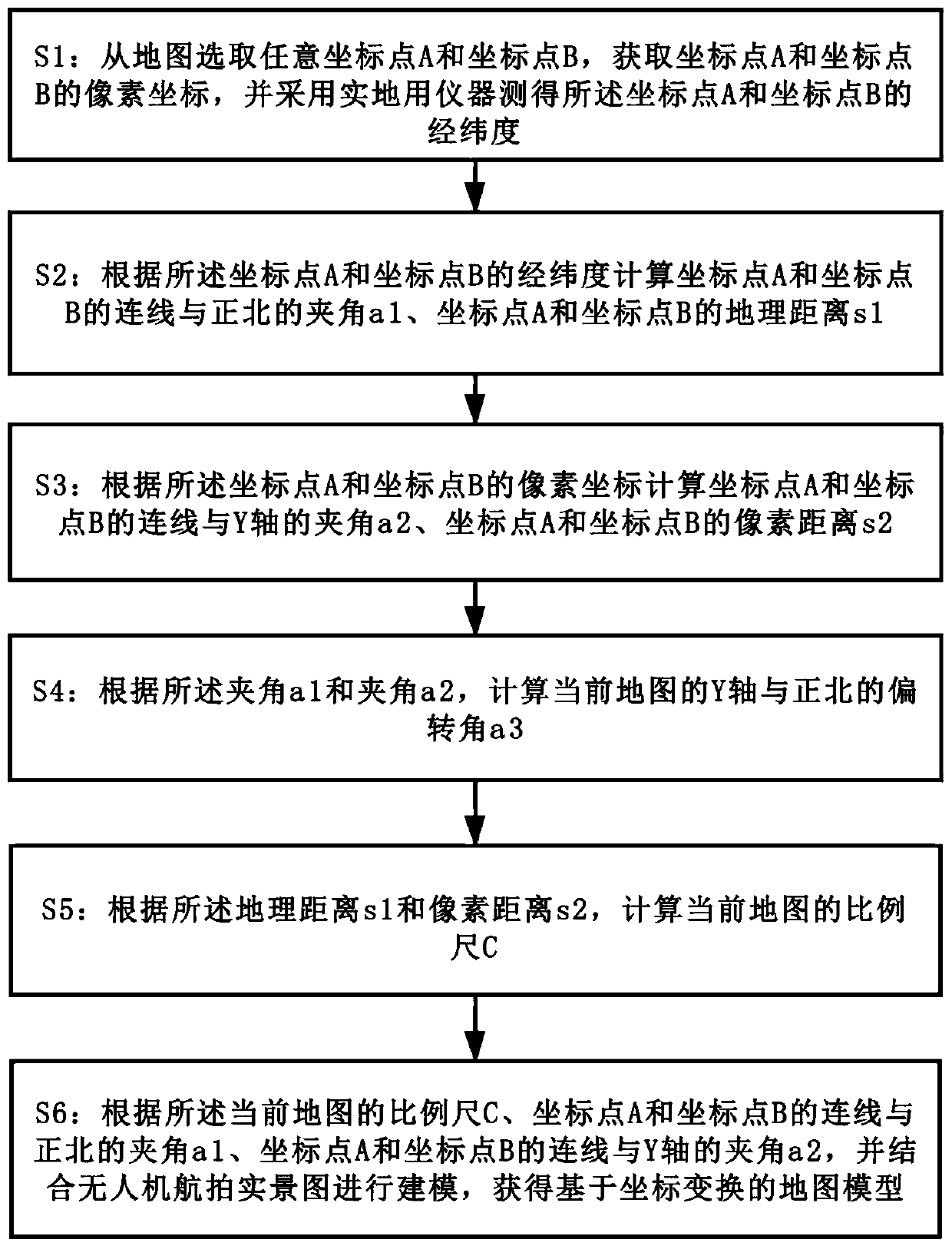
[0081] In this embodiment, a method for constructing a map model based on coordinate transformation is proposed, such as figure 1 As shown in FIG. 1 , they are respectively a flow chart of a method for constructing a map model based on coordinate transformation in this embodiment.
[0082] A method for constructing a map model based on coordinate transformation proposed in this embodiment includes the following steps:
[0083] S1: Select any coordinate point A and coordinate point B from the map, obtain the pixel coordinates of coordinate point A and coordinate point B, and measure the longitude and latitude of coordinate point A and coordinate point B with field instruments, where the longitude and latitude of coordinate point A is (lonA,latA), the latitude and longitude of coordinate point B is (lonB,latB).
[0084] S2: According to the longitude and latitude of coordinate point A and coordinate point B, calculate the angle a1 between the line connecting coordinate point A ...
Embodiment 2
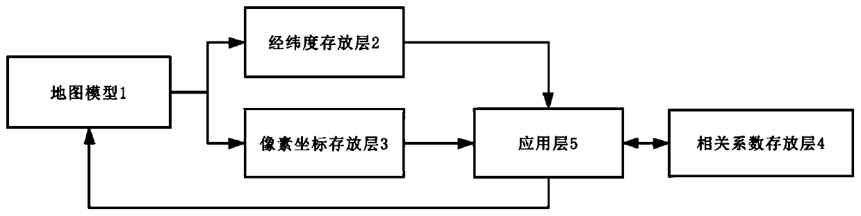
[0129] This embodiment proposes a coordinate transformation-based map model construction system, which is applied to a coordinate transformation-based map model construction method proposed in Embodiment 1. Such as image 3 Shown is a schematic structural diagram of the coordinate transformation-based map model construction system of this embodiment.
[0130] In the map model construction system based on coordinate transformation proposed in this embodiment, it includes a map model 1 constructed from a real scene picture taken by an unmanned aerial vehicle, a latitude and longitude storage layer 2, a pixel coordinate storage layer 3, a correlation coefficient storage layer 4, and an application layer 5. in:
[0131] The latitude and longitude storage layer 2 is connected with the map model 1, and is used to store the latitude and longitude of each coordinate point in the map model 1;
[0132] The pixel coordinate storage layer 3 is connected to the map model 1 for storing th...
PUM
Abstract
The invention provides a map model construction method based on coordinate transformation. The map model construction method comprises the steps of selecting an arbitrary coordinate point A and an arbitrary coordinate point B from a map, obtaining pixel coordinates of the arbitrary coordinate point A and the coordinate point B, and measuring the longitudes and latitudes of the coordinate point A and the coordinate point B by adopting a field instrument; calculating an included angle a1 between a connecting line of the coordinate point A and the coordinate point B and the north, and a geographic distance s1 between the coordinate point A and the coordinate point B; calculating an included angle a2 between a connecting line of the coordinate point A and the coordinate point B and a Y axis, and a pixel distance s2 between the coordinate point A and the coordinate point B; calculating a deflection angle a3 of the Y axis and the north of the current map; calculating a measuring scale C of the current map; according to the measuring scale C of the current map, the included angle a1 between the connecting line of the coordinate point A and the coordinate point B and the north, the included angle a2 between the connecting line of the coordinate point A and the coordinate point B and the Y axis, carrying out modeling by combining the aerial photography real scene of an unmanned aerial vehicle, and thus obtaining a map model based on coordinate transformation. The invention also provides a map model construction system based on coordinate transformation.
Description
technical field [0001] The present invention relates to the technical field of geographic information processing, and more specifically, to a method and system for constructing a map model based on coordinate transformation. Background technique [0002] With the continuous progress of society and the continuous development of computer information technology, various geographic information systems are applied in various fields. The current map system used in navigation and daily viewing of maps does not meet the needs of users for high-definition real-world maps. In particular, under specific requirements, such as distribution network modeling, small area modeling, etc., it is necessary to customize geographic information and In the case of insufficient geographical information in remote areas, the line network map is mainly used, while the real scene map has the problem of inaccurate positioning. Contents of the invention [0003] The present invention provides a method ...
Claims
Application Information
Patent Timeline
Application Date:The date an application was filed.
Publication Date:The date a patent or application was officially published.
First Publication Date:The earliest publication date of a patent with the same application number.
Issue Date:Publication date of the patent grant document.
PCT Entry Date:The Entry date of PCT National Phase.
Estimated Expiry Date:The statutory expiry date of a patent right according to the Patent Law, and it is the longest term of protection that the patent right can achieve without the termination of the patent right due to other reasons(Term extension factor has been taken into account ).
Invalid Date:Actual expiry date is based on effective date or publication date of legal transaction data of invalid patent.